Property Record
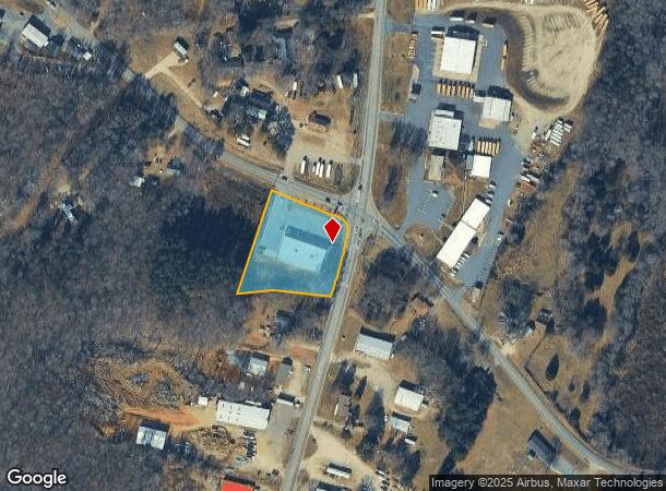
2639 N Aspen St, Lincolnton, NC 28092
NEARBY LISTINGS FOR SALE OR LEASE
Property Detail
2639 N Aspen St
Charlotte-Concord-Gastonia, NC-SC
Recombination Survey Of 1 500 Acres Deed
52506
TERAMORE DEVELOPMENT LLC
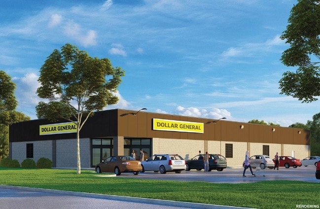
Storebuilding
Lincoln
2025
North Carolina
2025
1.55 AC
070201
Lincoln County
9,145 SF
Charlotte
DEMOGRAPHICS near 2639 N Aspen St
1 Mile
3 Mile
5 Mile
2024 Total Population
1,823
17,599
33,924
2029 Population
2,104
20,442
39,212
Pop Growth 2024-2029
+ 15.41%
+ 16.15%
+ 15.59%
Average Age
38
41
42
2024 Total Households
758
7,190
13,711
HH Growth 2024-2029
+ 15.83%
+ 16.52%
+ 15.92%
Median Household Inc
$51,579
$56,786
$60,337
Avg Household Size
2.30
2.40
2.40
2024 Avg HH Vehicles
2.00
2.00
2.00
Median Home Value
$170,748
$181,933
$181,619
Median Year Built
1996
1982
1984
Nearby Places
Map Layers
Map Styles
 Street
 Aerial
- Restaurants
- Banks
- Shops
- Fitness
- Groceries
PUBLIC TRANSPORTATION
AIRPORT
Charlotte/Douglas International
DRIVE
WALK
Distance
Charlotte/Douglas International
52 min
34.2 mi
Freight Ports
North Charleston Terminal
DRIVE
WALK
Distance
North Charleston Terminal
266 min
230.3 mi
SALE & LEASE HISTORY
LISTING DATE
SALE/LEASE

Aug 26, 2019
For Sale
Nearby Properties
Address
Land Use
TOTAL SIZE
Lot Size
Zoning
Address
Land Use
TOTAL SIZE
Lot Size
Zoning
172,724 SF
55.65 AC
O-I CU
Address
Land Use
TOTAL SIZE
Lot Size
Zoning
88,878 SF
7.21 AC
O-I
Address
Land Use
TOTAL SIZE
Lot Size
Zoning
29,244 SF
15.15 AC
R-O CU
Address
Land Use
TOTAL SIZE
Lot Size
Zoning
404,200 SF
44.83 AC
I-G
Address
Land Use
TOTAL SIZE
Lot Size
Zoning
362,664 SF
48.66 AC
I-G
Address
Land Use
TOTAL SIZE
Lot Size
Zoning
385,000 SF
33.43 AC
I-G
Address
Land Use
TOTAL SIZE
Lot Size
Zoning
415,540 SF
29.21 AC
I-G
Address
Land Use
TOTAL SIZE
Lot Size
Zoning
6,144 SF
13.26 AC
P-B & RMF
Address
Land Use
TOTAL SIZE
Lot Size
Zoning
279,874 SF
30.15 AC
I-G
Address
Land Use
TOTAL SIZE
Lot Size
Zoning
118,694 SF
25.90 AC
R-10
Address
Land Use
TOTAL SIZE
Lot Size
Zoning
307,200 SF
35.25 AC
I-G
Address
Land Use
TOTAL SIZE
Lot Size
Zoning
45,354 SF
50.76 AC
R-10
Address
Land Use
TOTAL SIZE
Lot Size
Zoning
130,730 SF
54.59 AC
R-15
Address
Land Use
TOTAL SIZE
Lot Size
Zoning
53,152 SF
3.97 AC
G-B CD
Address
Land Use
TOTAL SIZE
Lot Size
Zoning
272,580 SF
22.64 AC
I-G
Address
Land Use
TOTAL SIZE
Lot Size
Zoning
189,220 SF
23.64 AC
P-B CU
Address
Land Use
TOTAL SIZE
Lot Size
Zoning
80,509 SF
16.23 AC
P-B CU
Address
Land Use
TOTAL SIZE
Lot Size
Zoning
174,720 SF
24.81 AC
I-G
Address
Land Use
TOTAL SIZE
Lot Size
Zoning
36,448 SF
7.73 AC
RMF
Address
Land Use
TOTAL SIZE
Lot Size
Zoning
10,120 SF
23.38 AC
G-B & P-B
Address
Land Use
TOTAL SIZE
Lot Size
Zoning
42,405 SF
34.47 AC
GMC
Address
Land Use
TOTAL SIZE
Lot Size
Zoning
148,421 SF
14.44 AC
I-G
Address
Land Use
TOTAL SIZE
Lot Size
Zoning
2,047 SF
46.35 AC
RMF
Address
Land Use
TOTAL SIZE
Lot Size
Zoning
39,860 SF
3.71 AC
O-I
Address
Land Use
TOTAL SIZE
Lot Size
Zoning
105,148 SF
12.53 AC
I-G
Address
Land Use
TOTAL SIZE
Lot Size
Zoning
8,770 SF
11.21 AC
P-B
Address
Land Use
TOTAL SIZE
Lot Size
Zoning
119,354 SF
20.15 AC
I-G
Address
Land Use
TOTAL SIZE
Lot Size
Zoning
120,810 SF
16.90 AC
G-B CU
Address
Land Use
TOTAL SIZE
Lot Size
Zoning
66,527 SF
2.10 AC
R-15
Address
Land Use
TOTAL SIZE
Lot Size
Zoning
40,203 SF
3.37 AC
P-B
The World's #1 Commercial Real Estate Marketplace
Connect with us
© 2025 CoStar Group
The information above has been obtained from sources believed reliable. While we do not doubt its accuracy we have not verified it and make no guarantee, warranty or representation about it. It is your responsibility to independently confirm its accuracy and completeness. Any projections, opinions, assumptions, or estimates used are for example only and do not represent the current or future performance of the property. The value of this transaction to you depends on tax and other factors which should be evaluated by your tax, financial, and legal advisors. You and your advisors should conduct a careful, independent investigation of the property to determine to your satisfaction the suitability of the property for your needs.