Property Record
2639 Prairie Ave, Beloit, WI 53511

Save to a Folder
{{folder.Name}}
{{folder.ListingIds.length}} Properties
{{folder.ListingIds.length}} Property
Create a New Folder
Property Detail
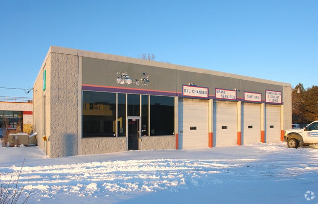
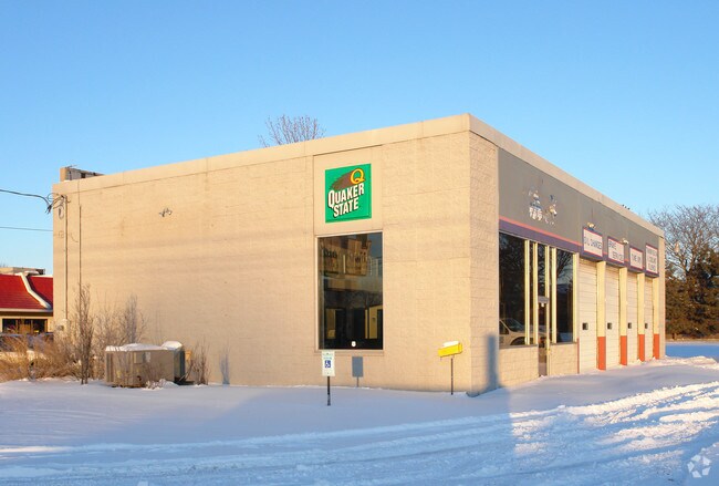
2639 Prairie Ave
Janesville-Beloit, WI
L 1 C S M VOL 11 PAGES 237 - 238 EXCEPTING THEREFROM THE EAST 24 FT THEREOF
218-50465
ROCK
Commercialnec
Wisconsin
B and X Area of moderate flood hazard, usually the area between the limits of the 100-year and 500-year floods.
1
2025
0.43 AC
2025
Rock County
002601
Milwaukee/Madison
3,182 SF
NEARBY LISTINGS FOR SALE OR LEASE
DEMOGRAPHICS near 2639 Prairie Ave
1 mile
3 mile
5 mile
2025 Total Population
6,232
32,077
57,252
2030 Population
6,247
32,329
57,859
Pop Growth 2025-2030
+ 0.24%
+ 0.79%
+ 1.06%
Average Age
43
40
40
2025 Total Households
2,649
12,713
22,440
HH Growth 2025-2030
+ 0.23%
+ 0.81%
+ 1.07%
Median Household Inc
$76,087
$65,871
$65,634
Avg Household Size
2.30
2.40
2.40
2025 Avg HH Vehicles
2.00
2.00
2.00
Median Home Value
$209,756
$201,331
$183,181
Median Year Built
1975
1963
1963
Nearby Places
Map Layers
Map Styles
 Street
 Aerial
Layers
 Traffic
 Biking
Places
Listings with unknown addresses are not visible on the map
- Restaurants
- Banks
- Shops
- Fitness
- Groceries
PUBLIC TRANSPORTATION
AIRPORT
Chicago/Rockford International
Drive
Walk
Distance
Chicago/Rockford International
48 min
34.8 mi
Freight Ports
Port Milwaukee
Drive
Walk
Distance
Port Milwaukee
87 min
73.6 mi
Nearby Properties
Address
Land Use
TOTAL SIZE
Lot Size
Zoning
Address
Land Use
TOTAL SIZE
Lot Size
Zoning
264,000 SF
34 AC
Address
Land Use
TOTAL SIZE
Lot Size
Zoning
37.49 AC
CHI
Address
Land Use
TOTAL SIZE
Lot Size
Zoning
8.01 AC
Address
Land Use
TOTAL SIZE
Lot Size
Zoning
39.83 AC
Address
Land Use
TOTAL SIZE
Lot Size
Zoning
24.76 AC
Address
Land Use
TOTAL SIZE
Lot Size
Zoning
36,860 SF
11.26 AC
Address
Land Use
TOTAL SIZE
Lot Size
Zoning
202,676 SF
19.31 AC
Address
Land Use
TOTAL SIZE
Lot Size
Zoning
61,820 SF
5.63 AC
Address
Land Use
TOTAL SIZE
Lot Size
Zoning
103,761 SF
21.59 AC
Address
Land Use
TOTAL SIZE
Lot Size
Zoning
55.03 AC
Address
Land Use
TOTAL SIZE
Lot Size
Zoning
7.71 AC
Address
Land Use
TOTAL SIZE
Lot Size
Zoning
400,014 SF
43.71 AC
Address
Land Use
TOTAL SIZE
Lot Size
Zoning
32.08 AC
Address
Land Use
TOTAL SIZE
Lot Size
Zoning
3.47 AC
Address
Land Use
TOTAL SIZE
Lot Size
Zoning
233,850 SF
30.40 AC
Address
Land Use
TOTAL SIZE
Lot Size
Zoning
3.65 AC
Address
Land Use
TOTAL SIZE
Lot Size
Zoning
90.81 AC
Address
Land Use
TOTAL SIZE
Lot Size
Zoning
13.21 AC
Address
Land Use
TOTAL SIZE
Lot Size
Zoning
2,728 SF
10 AC
Address
Land Use
TOTAL SIZE
Lot Size
Zoning
231,166 SF
19.25 AC
Address
Land Use
TOTAL SIZE
Lot Size
Zoning
361,947 SF
23.26 AC
Address
Land Use
TOTAL SIZE
Lot Size
Zoning
24.15 AC
Address
Land Use
TOTAL SIZE
Lot Size
Zoning
193,013 SF
22.93 AC
Address
Land Use
TOTAL SIZE
Lot Size
Zoning
38,012 SF
2.74 AC
Address
Land Use
TOTAL SIZE
Lot Size
Zoning
40,800 SF
81.29 AC
Address
Land Use
TOTAL SIZE
Lot Size
Zoning
22.90 AC
Address
Land Use
TOTAL SIZE
Lot Size
Zoning
27.69 AC
Address
Land Use
TOTAL SIZE
Lot Size
Zoning
9,208 SF
10.33 AC
Address
Land Use
TOTAL SIZE
Lot Size
Zoning
30,000 SF
3.31 AC
Address
Land Use
TOTAL SIZE
Lot Size
Zoning
101,660 SF
10.14 AC
The World's #1 Commercial Real Estate Marketplace
Connect with us
© 2026 CoStar Group
The information above has been obtained from sources believed reliable. While we do not doubt its accuracy we have not verified it and make no guarantee, warranty or representation about it. It is your responsibility to independently confirm its accuracy and completeness. Any projections, opinions, assumptions, or estimates used are for example only and do not represent the current or future performance of the property. The value of this transaction to you depends on tax and other factors which should be evaluated by your tax, financial, and legal advisors. You and your advisors should conduct a careful, independent investigation of the property to determine to your satisfaction the suitability of the property for your needs.