Property Record
3906 Produce Rd, Louisville, KY 40218


Save to a Folder
{{folder.Name}}
{{folder.ListingIds.length}} Properties
{{folder.ListingIds.length}} Property
Create a New Folder
Property Detail
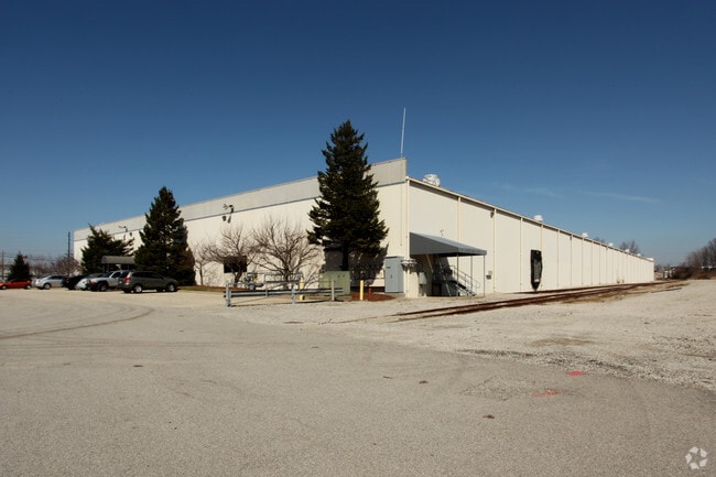
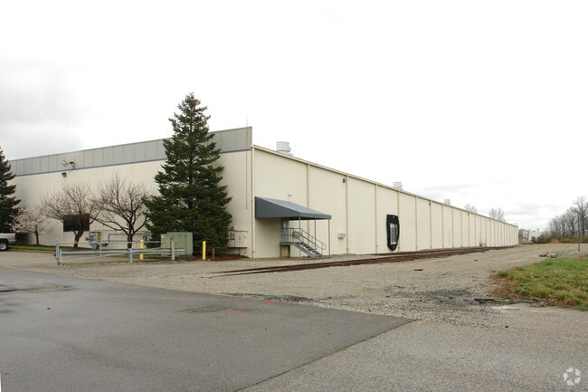
3906 Produce Rd
061601600000
TRACT 2 MINOR PLAT MB 2679 X 330, 6.31 AC +/-
Commercialbuilding
Jefferson
M2-INDUSTR
Kentucky
B and X Area of moderate flood hazard, usually the area between the limits of the 100-year and 500-year floods.
6.31 AC
2025
South Central
2025
Louisville
011301
Louisville/Jefferson County, KY-IN
120,400 SF
NEARBY LISTINGS FOR SALE OR LEASE
DEMOGRAPHICS near 3906 Produce Rd
1 mile
3 mile
5 mile
2025 Total Population
5,990
82,742
236,788
2030 Population
6,116
84,171
240,562
Pop Growth 2025-2030
+ 2.10%
+ 1.73%
+ 1.59%
Average Age
38
39
40
2025 Total Households
2,353
34,597
102,311
HH Growth 2025-2030
+ 2.12%
+ 1.79%
+ 1.66%
Median Household Inc
$45,830
$58,532
$63,156
Avg Household Size
2.40
2.30
2.20
2025 Avg HH Vehicles
2.00
2.00
2.00
Median Home Value
$130,326
$217,619
$246,434
Median Year Built
1964
1963
1962
Nearby Places
Map Layers
Map Styles
 Street
 Aerial
Layers
 Traffic
 Biking
Places
Listings with unknown addresses are not visible on the map
- Restaurants
- Banks
- Shops
- Fitness
- Groceries
PUBLIC TRANSPORTATION
AIRPORT
Louisville Muhammad Ali International
Drive
Walk
Distance
Louisville Muhammad Ali International
16 min
7.6 mi
SALE & LEASE HISTORY
LISTING DATE
SALE/LEASE

Sep 25, 2019
For Lease
Nearby Properties
Address
Land Use
TOTAL SIZE
Lot Size
Zoning
Address
Land Use
TOTAL SIZE
Lot Size
Zoning
377,041 SF
469.53 AC
Address
Land Use
TOTAL SIZE
Lot Size
Zoning
85,882 SF
80.13 AC
R1-RESIDEN
Address
Land Use
TOTAL SIZE
Lot Size
Zoning
127,824 SF
53.76 AC
M2-INDUSTR
Address
Land Use
TOTAL SIZE
Lot Size
Zoning
19.16 AC
Address
Land Use
TOTAL SIZE
Lot Size
Zoning
102,600 SF
173.89 AC
EZ1-ENTERP
Address
Land Use
TOTAL SIZE
Lot Size
Zoning
14,166 SF
16.32 AC
C1-COMMERC
Address
Land Use
TOTAL SIZE
Lot Size
Zoning
407,840 SF
25.51 AC
C2-COMMERC
Address
Land Use
TOTAL SIZE
Lot Size
Zoning
4,745 SF
17.95 AC
Address
Land Use
TOTAL SIZE
Lot Size
Zoning
12,852 SF
10.85 AC
R7-RESIDEN
Address
Land Use
TOTAL SIZE
Lot Size
Zoning
273,585 SF
42.27 AC
Address
Land Use
TOTAL SIZE
Lot Size
Zoning
5,200 SF
7.55 AC
R7-RESIDEN
Address
Land Use
TOTAL SIZE
Lot Size
Zoning
142,874 SF
21.93 AC
R5-RESIDEN
Address
Land Use
TOTAL SIZE
Lot Size
Zoning
1,450 SF
87.64 AC
M2-INDUSTR
Address
Land Use
TOTAL SIZE
Lot Size
Zoning
217,082 SF
26.08 AC
C1-COMMERC
Address
Land Use
TOTAL SIZE
Lot Size
Zoning
401,443 SF
28.92 AC
M2-INDUSTR
Address
Land Use
TOTAL SIZE
Lot Size
Zoning
2,575 SF
4.39 AC
CM-COMMERC
Address
Land Use
TOTAL SIZE
Lot Size
Zoning
27.92 AC
EZ1-ENTERP
Address
Land Use
TOTAL SIZE
Lot Size
Zoning
16,836 SF
13.72 AC
R6-RESIDEN
Address
Land Use
TOTAL SIZE
Lot Size
Zoning
25,326 SF
11.36 AC
R7-RESIDEN
Address
Land Use
TOTAL SIZE
Lot Size
Zoning
370,297 SF
28.31 AC
M2-INDUSTR
Address
Land Use
TOTAL SIZE
Lot Size
Zoning
17.17 AC
EZ1-ENTERP
Address
Land Use
TOTAL SIZE
Lot Size
Zoning
6,570 SF
7.06 AC
R7-RESIDEN
Address
Land Use
TOTAL SIZE
Lot Size
Zoning
24,290 SF
14.88 AC
C2-COMMERC
Address
Land Use
TOTAL SIZE
Lot Size
Zoning
18.67 AC
Address
Land Use
TOTAL SIZE
Lot Size
Zoning
18,770 SF
EZ1-ENTERP
Address
Land Use
TOTAL SIZE
Lot Size
Zoning
6,092 SF
7.65 AC
R5-RESIDEN
Address
Land Use
TOTAL SIZE
Lot Size
Zoning
4,000 SF
15.46 AC
C2-COMMERC
Address
Land Use
TOTAL SIZE
Lot Size
Zoning
14.13 AC
R4-RESIDEN
Address
Land Use
TOTAL SIZE
Lot Size
Zoning
15.08 AC
C1-COMMERC
Address
Land Use
TOTAL SIZE
Lot Size
Zoning
15,168 SF
9.12 AC
C2-COMMERC
The World's #1 Commercial Real Estate Marketplace
Connect with us
© 2026 CoStar Group
The information above has been obtained from sources believed reliable. While we do not doubt its accuracy we have not verified it and make no guarantee, warranty or representation about it. It is your responsibility to independently confirm its accuracy and completeness. Any projections, opinions, assumptions, or estimates used are for example only and do not represent the current or future performance of the property. The value of this transaction to you depends on tax and other factors which should be evaluated by your tax, financial, and legal advisors. You and your advisors should conduct a careful, independent investigation of the property to determine to your satisfaction the suitability of the property for your needs.