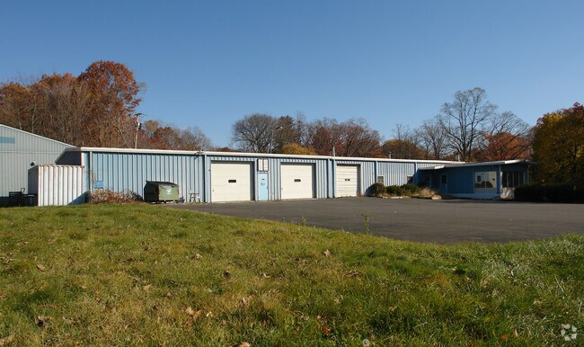
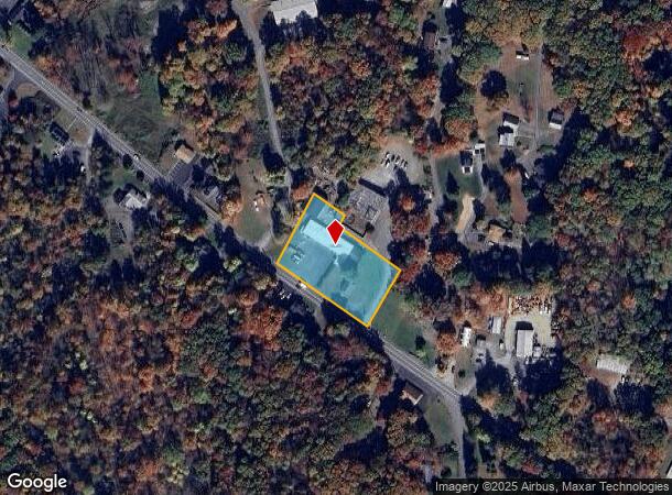
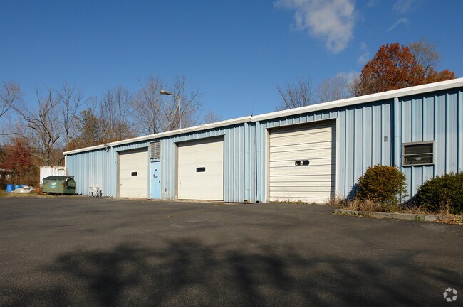
Property Record
264 N Plank Rd, Newburgh, NY 12550
NEARBY LISTINGS FOR SALE OR LEASE
Property Detail
264 N Plank Rd
334600-034-000-0003-002.000-0000
Orange
Commercialnec
New York
X
2.000
36111C0900F
1.30 AC
2024
Orange County
2024
Northern New Jersey
010101
New York-Jersey City-White Plains, NY-NJ
884 SF
DEMOGRAPHICS near 264 N Plank Rd
1 Mile
3 Mile
5 Mile
2024 Total Population
2,588
28,426
80,028
2029 Population
2,659
28,972
81,250
Pop Growth 2024-2029
+ 2.74%
+ 1.92%
+ 1.53%
Average Age
41
41
39
2024 Total Households
863
10,350
29,048
HH Growth 2024-2029
+ 2.78%
+ 1.95%
+ 1.60%
Median Household Inc
$104,841
$98,854
$83,054
Avg Household Size
2.80
2.60
2.60
2024 Avg HH Vehicles
2.00
2.00
2.00
Median Home Value
$314,062
$298,416
$296,490
Median Year Built
1976
1971
1966
Nearby Places
- Restaurants
- Banks
- Shops
- Fitness
- Groceries
PUBLIC TRANSPORTATION
COMMUTER RAIL
Beacon Station (Hudson Line - Metro-North Commuter Railroad Company (Metro-North))
DRIVE
WALK
Distance
Beacon Station (Hudson Line - Metro-North Commuter Railroad Company (Metro-North))
12 min
6.4 mi
AIRPORT
New York Stewart International
DRIVE
WALK
Distance
New York Stewart International
16 min
8.0 mi
Nearby Properties
Address
Land Use
TOTAL SIZE
Lot Size
Zoning
Address
Land Use
TOTAL SIZE
Lot Size
Zoning
345,572 SF
43.80 AC
R-1
Address
Land Use
TOTAL SIZE
Lot Size
Zoning
927,041 SF
104.37 AC
Address
Land Use
TOTAL SIZE
Lot Size
Zoning
272,943 SF
17 AC
RL
Address
Land Use
TOTAL SIZE
Lot Size
Zoning
130,037 SF
128.80 AC
Address
Land Use
TOTAL SIZE
Lot Size
Zoning
213,521 SF
8 AC
RH
Address
Land Use
TOTAL SIZE
Lot Size
Zoning
44.50 AC
Address
Land Use
TOTAL SIZE
Lot Size
Zoning
505,577 SF
50.50 AC
Address
Land Use
TOTAL SIZE
Lot Size
Zoning
265,660 SF
24.20 AC
Address
Land Use
TOTAL SIZE
Lot Size
Zoning
Address
Land Use
TOTAL SIZE
Lot Size
Zoning
29,935 SF
31.60 AC
04
Address
Land Use
TOTAL SIZE
Lot Size
Zoning
67,448 SF
6.30 AC
RL
Address
Land Use
TOTAL SIZE
Lot Size
Zoning
71,379 SF
20.80 AC
Address
Land Use
TOTAL SIZE
Lot Size
Zoning
200,000 SF
13.80 AC
CD
Address
Land Use
TOTAL SIZE
Lot Size
Zoning
97,011 SF
19.70 AC
Address
Land Use
TOTAL SIZE
Lot Size
Zoning
115,361 SF
17.70 AC
IND
Address
Land Use
TOTAL SIZE
Lot Size
Zoning
30,801 SF
2.40 AC
IND
Address
Land Use
TOTAL SIZE
Lot Size
Zoning
69,748 SF
13.85 AC
RH
Address
Land Use
TOTAL SIZE
Lot Size
Zoning
215,219 SF
14.57 AC
Address
Land Use
TOTAL SIZE
Lot Size
Zoning
Address
Land Use
TOTAL SIZE
Lot Size
Zoning
22,088 SF
5.02 AC
IND
Address
Land Use
TOTAL SIZE
Lot Size
Zoning
49.60 AC
IND
Address
Land Use
TOTAL SIZE
Lot Size
Zoning
Address
Land Use
TOTAL SIZE
Lot Size
Zoning
Address
Land Use
TOTAL SIZE
Lot Size
Zoning
125,946 SF
13.20 AC
Address
Land Use
TOTAL SIZE
Lot Size
Zoning
173,319 SF
28.30 AC
04
Address
Land Use
TOTAL SIZE
Lot Size
Zoning
75,620 SF
12.80 AC
Address
Land Use
TOTAL SIZE
Lot Size
Zoning
Address
Land Use
TOTAL SIZE
Lot Size
Zoning
61,822 SF
7.30 AC
Address
Land Use
TOTAL SIZE
Lot Size
Zoning
60,420 SF
8.60 AC
Address
Land Use
TOTAL SIZE
Lot Size
Zoning
149,085 SF
48.90 AC
The World's #1 Commercial Real Estate Marketplace
Connect with us
© 2025 CoStar Group
The information above has been obtained from sources believed reliable. While we do not doubt its accuracy we have not verified it and make no guarantee, warranty or representation about it. It is your responsibility to independently confirm its accuracy and completeness. Any projections, opinions, assumptions, or estimates used are for example only and do not represent the current or future performance of the property. The value of this transaction to you depends on tax and other factors which should be evaluated by your tax, financial, and legal advisors. You and your advisors should conduct a careful, independent investigation of the property to determine to your satisfaction the suitability of the property for your needs.