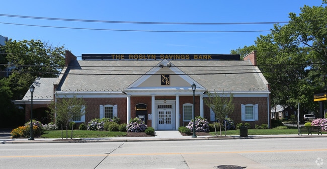
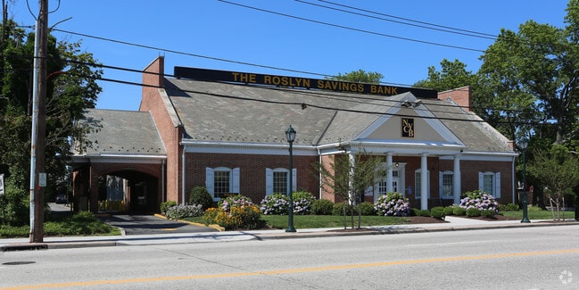
Property Record
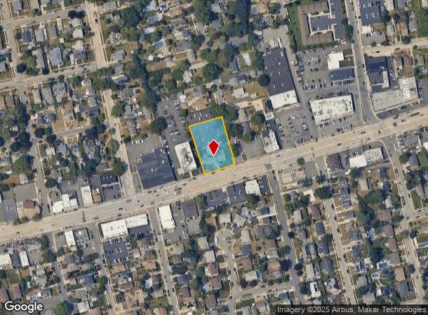
2641 Merrick Rd, Bellmore, NY 11710
NEARBY LISTINGS FOR SALE OR LEASE
Property Detail
2641 Merrick Rd
2089-56-336-00-0081-0
TOWN #1 SCH DIST 007
Financialbuilding
Nassau
X
New York
36059C0242G
81-82
2025
0.66 AC
2025
Southeast Nassau
415401
Long Island (New York)
5,594 SF
Nassau County-Suffolk County, NY
DEMOGRAPHICS near 2641 Merrick Rd
1 Mile
3 Mile
5 Mile
2024 Total Population
19,565
138,296
383,775
2029 Population
19,197
135,534
376,468
Pop Growth 2024-2029
(1.88%)
(2.00%)
(1.90%)
Average Age
42
41
41
2024 Total Households
6,642
44,862
120,255
HH Growth 2024-2029
(2.08%)
(2.12%)
(2.02%)
Median Household Inc
$150,854
$147,425
$131,431
Avg Household Size
2.90
3.00
3.10
2024 Avg HH Vehicles
2.00
2.00
2.00
Median Home Value
$696,082
$668,312
$593,092
Median Year Built
1955
1955
1954
Nearby Places
- Restaurants
- Banks
- Shops
- Fitness
- Groceries
PUBLIC TRANSPORTATION
COMMUTER RAIL
Bellmore Station (Babylon Branch - Long Island Rail Road)
DRIVE
WALK
Distance
Bellmore Station (Babylon Branch - Long Island Rail Road)
2 min
11 min
0.6 mi
Merrick Station (Babylon Branch - Long Island Rail Road)
DRIVE
WALK
Distance
Merrick Station (Babylon Branch - Long Island Rail Road)
3 min
1.5 mi
AIRPORT
John F Kennedy International
DRIVE
WALK
Distance
John F Kennedy International
25 min
16.6 mi
LaGuardia
DRIVE
WALK
Distance
LaGuardia
35 min
23.6 mi
Long Island MacArthur
DRIVE
WALK
Distance
Long Island MacArthur
37 min
27.2 mi
Freight Ports
NY - Red Hook Container Terminal
DRIVE
WALK
Distance
NY - Red Hook Container Terminal
46 min
28.0 mi
Nearby Properties
Address
Land Use
TOTAL SIZE
Lot Size
Zoning
Address
Land Use
TOTAL SIZE
Lot Size
Zoning
49,840 SF
729.60 AC
Address
Land Use
TOTAL SIZE
Lot Size
Zoning
20,080 SF
91.79 AC
Address
Land Use
TOTAL SIZE
Lot Size
Zoning
105,868 SF
198 AC
Address
Land Use
TOTAL SIZE
Lot Size
Zoning
986.74 AC
Address
Land Use
TOTAL SIZE
Lot Size
Zoning
4,356 SF
246.70 AC
Address
Land Use
TOTAL SIZE
Lot Size
Zoning
169.25 AC
Address
Land Use
TOTAL SIZE
Lot Size
Zoning
173.70 AC
Address
Land Use
TOTAL SIZE
Lot Size
Zoning
20,000 SF
123.34 AC
Address
Land Use
TOTAL SIZE
Lot Size
Zoning
19.88 AC
Address
Land Use
TOTAL SIZE
Lot Size
Zoning
249,762 SF
18.36 AC
Address
Land Use
TOTAL SIZE
Lot Size
Zoning
95.90 AC
Address
Land Use
TOTAL SIZE
Lot Size
Zoning
3,900 SF
52.04 AC
Address
Land Use
TOTAL SIZE
Lot Size
Zoning
57,874 SF
21 AC
Address
Land Use
TOTAL SIZE
Lot Size
Zoning
65,235 SF
15.48 AC
Address
Land Use
TOTAL SIZE
Lot Size
Zoning
116.80 AC
Address
Land Use
TOTAL SIZE
Lot Size
Zoning
145,209 SF
20.01 AC
Address
Land Use
TOTAL SIZE
Lot Size
Zoning
9,515 SF
121.73 AC
Address
Land Use
TOTAL SIZE
Lot Size
Zoning
67,408 SF
66.13 AC
Address
Land Use
TOTAL SIZE
Lot Size
Zoning
120,000 SF
28.96 AC
Address
Land Use
TOTAL SIZE
Lot Size
Zoning
80,895 SF
26.22 AC
Address
Land Use
TOTAL SIZE
Lot Size
Zoning
225,460 SF
14.70 AC
Address
Land Use
TOTAL SIZE
Lot Size
Zoning
2,145 SF
52.37 AC
Address
Land Use
TOTAL SIZE
Lot Size
Zoning
86.38 AC
Address
Land Use
TOTAL SIZE
Lot Size
Zoning
1,181 SF
25.01 AC
Address
Land Use
TOTAL SIZE
Lot Size
Zoning
81 AC
Address
Land Use
TOTAL SIZE
Lot Size
Zoning
253,201 SF
16.01 AC
Address
Land Use
TOTAL SIZE
Lot Size
Zoning
112,053 SF
16.13 AC
Address
Land Use
TOTAL SIZE
Lot Size
Zoning
168,070 SF
11.29 AC
Address
Land Use
TOTAL SIZE
Lot Size
Zoning
65,102 SF
27.67 AC
Address
Land Use
TOTAL SIZE
Lot Size
Zoning
28.33 AC
The World's #1 Commercial Real Estate Marketplace
Connect with us
© 2025 CoStar Group
The information above has been obtained from sources believed reliable. While we do not doubt its accuracy we have not verified it and make no guarantee, warranty or representation about it. It is your responsibility to independently confirm its accuracy and completeness. Any projections, opinions, assumptions, or estimates used are for example only and do not represent the current or future performance of the property. The value of this transaction to you depends on tax and other factors which should be evaluated by your tax, financial, and legal advisors. You and your advisors should conduct a careful, independent investigation of the property to determine to your satisfaction the suitability of the property for your needs.