Property Record
2641 Michael Pl, Dunedin, FL 34698
NEARBY LISTINGS FOR SALE OR LEASE
Property Detail
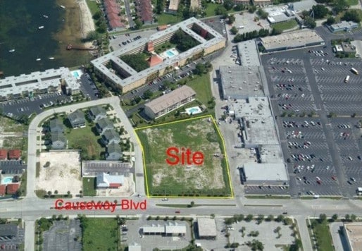
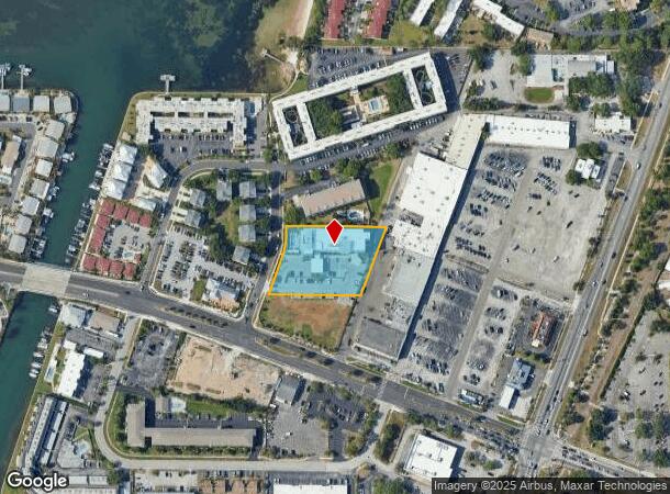
2641 Michael Pl
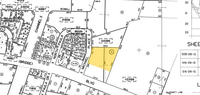
15-28-15-23166-001-0000
Dunedin Causeway Center
Hotel
DUNEDIN CAUSEWAY CENTER PART OF BLK A & VAC 20FT ALLEY ADJ TOGETHER WITH PART OF NE 1/4 OF SEC 15-28-15 ALL DESC AS FROM SW COR OF SD BLK A TH N69D0917W 266.25FT TH N20D5043E 107FT FOR POB TH N20D5043E 122.47FT TH CUR LT RAD 140FT ARC 48.18FT CB N13D
AE
Pinellas
12103C0066H
Florida
2024
1.45 AC
2025
North Pinellas
027209
Tampa/St Petersburg
67,340 SF
Tampa-St. Petersburg-Clearwater, FL
DEMOGRAPHICS near 2641 Michael Pl
1 mile
3 mile
5 mile
2024 Total Population
7,184
52,648
155,392
2029 Population
7,282
52,586
155,322
Pop Growth 2024-2029
+ 1.36%
(0.12%)
(0.05%)
Average Age
55
50
49
2024 Total Households
3,705
24,540
73,104
HH Growth 2024-2029
+ 1.40%
(0.15%)
(0.13%)
Median Household Inc
$57,614
$63,022
$60,601
Avg Household Size
1.90
2.10
2.00
2024 Avg HH Vehicles
1.00
2.00
2.00
Median Home Value
$342,598
$331,698
$293,012
Median Year Built
1979
1978
1980
Nearby Places
Map Layers
Map Styles
 Street
 Aerial
Transit
 Traffic
 Biking
Places
Listings with unknown addresses are not visible on the map
- Restaurants
- Banks
- Shops
- Fitness
- Groceries
PUBLIC TRANSPORTATION
AIRPORT
St Pete-Clearwater International
Drive
Walk
Distance
St Pete-Clearwater International
24 min
14.9 mi
Tampa International
Drive
Walk
Distance
Tampa International
36 min
19.3 mi
Freight Ports
Port of Tampa Bay
Drive
Walk
Distance
Port of Tampa Bay
49 min
27.8 mi
Nearby Properties
Address
Land Use
TOTAL SIZE
Lot Size
Zoning
Address
Land Use
TOTAL SIZE
Lot Size
Zoning
167,201 SF
63.11 AC
AE
Address
Land Use
TOTAL SIZE
Lot Size
Zoning
412,099 SF
49.21 AC
Address
Land Use
TOTAL SIZE
Lot Size
Zoning
270,606 SF
53.27 AC
AE
Address
Land Use
TOTAL SIZE
Lot Size
Zoning
242,708 SF
26.17 AC
RPD10
Address
Land Use
TOTAL SIZE
Lot Size
Zoning
362,238 SF
13.80 AC
Address
Land Use
TOTAL SIZE
Lot Size
Zoning
239,480 SF
18.89 AC
RPD5
Address
Land Use
TOTAL SIZE
Lot Size
Zoning
4,250 SF
235.09 AC
Address
Land Use
TOTAL SIZE
Lot Size
Zoning
117,024 SF
56.52 AC
Address
Land Use
TOTAL SIZE
Lot Size
Zoning
161,404 SF
18.48 AC
CP2
Address
Land Use
TOTAL SIZE
Lot Size
Zoning
191,375 SF
13.58 AC
AE
Address
Land Use
TOTAL SIZE
Lot Size
Zoning
199,825 SF
22.75 AC
R2
Address
Land Use
TOTAL SIZE
Lot Size
Zoning
250,113 SF
39.50 AC
Address
Land Use
TOTAL SIZE
Lot Size
Zoning
116,975 SF
9 AC
AE
Address
Land Use
TOTAL SIZE
Lot Size
Zoning
201,208 SF
2.16 AC
Address
Land Use
TOTAL SIZE
Lot Size
Zoning
173,160 SF
5.39 AC
Address
Land Use
TOTAL SIZE
Lot Size
Zoning
107,766 SF
25.15 AC
Address
Land Use
TOTAL SIZE
Lot Size
Zoning
158,400 SF
9.80 AC
Address
Land Use
TOTAL SIZE
Lot Size
Zoning
396,841 SF
9.73 AC
Address
Land Use
TOTAL SIZE
Lot Size
Zoning
415,593 SF
29.66 AC
Address
Land Use
TOTAL SIZE
Lot Size
Zoning
99,361 SF
12.64 AC
CP1
Address
Land Use
TOTAL SIZE
Lot Size
Zoning
92,817 SF
6.42 AC
PC
Address
Land Use
TOTAL SIZE
Lot Size
Zoning
76,848 SF
12.60 AC
AE
Address
Land Use
TOTAL SIZE
Lot Size
Zoning
8,336 SF
28.56 AC
AE
Address
Land Use
TOTAL SIZE
Lot Size
Zoning
5,609 SF
28.25 AC
R6
Address
Land Use
TOTAL SIZE
Lot Size
Zoning
105,830 SF
10.84 AC
CP2
Address
Land Use
TOTAL SIZE
Lot Size
Zoning
90,791 SF
6.92 AC
Address
Land Use
TOTAL SIZE
Lot Size
Zoning
97,776 SF
9.63 AC
Address
Land Use
TOTAL SIZE
Lot Size
Zoning
103,393 SF
17.68 AC
R4
Address
Land Use
TOTAL SIZE
Lot Size
Zoning
101,243 SF
5.36 AC
M1
Address
Land Use
TOTAL SIZE
Lot Size
Zoning
2,280 SF
17.27 AC
The World's #1 Commercial Real Estate Marketplace
Connect with us
© 2026 CoStar Group
The information above has been obtained from sources believed reliable. While we do not doubt its accuracy we have not verified it and make no guarantee, warranty or representation about it. It is your responsibility to independently confirm its accuracy and completeness. Any projections, opinions, assumptions, or estimates used are for example only and do not represent the current or future performance of the property. The value of this transaction to you depends on tax and other factors which should be evaluated by your tax, financial, and legal advisors. You and your advisors should conduct a careful, independent investigation of the property to determine to your satisfaction the suitability of the property for your needs.