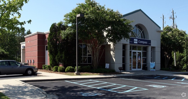
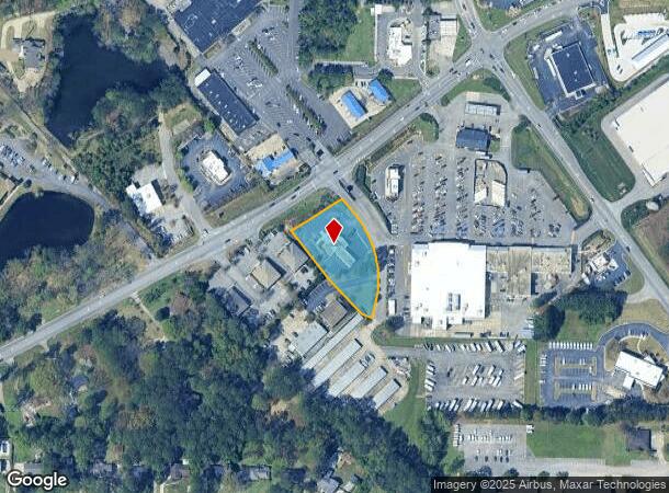
Property Record
2641 Valleydale Rd, Hoover, AL 35244

Current Lease Availabilities
NEARBY LISTINGS FOR SALE OR LEASE
-
-
View all Hoover listings for lease on LoopNet.com
Property Detail
2641 Valleydale Rd
Birmingham-Hoover, AL
Central Bank Subdivision
10-5-15-0-001-055-002
LESS: RD ROW ACQD BY ALDOT PROJ NO STPBH 9802(905)
Financialbuilding
Shelby
X
Alabama
01117C0088F
1
2024
1.10 AC
2024
Hwy 280/Shelby County
030305
Birmingham
2,484 SF
DEMOGRAPHICS near 2641 Valleydale Rd
1 Mile
3 Mile
5 Mile
2024 Total Population
3,264
35,259
104,038
2029 Population
3,511
36,645
106,791
Pop Growth 2024-2029
+ 7.57%
+ 3.93%
+ 2.65%
Average Age
43
41
40
2024 Total Households
1,125
14,280
44,462
HH Growth 2024-2029
+ 7.73%
+ 3.50%
+ 2.42%
Median Household Inc
$132,624
$99,196
$84,966
Avg Household Size
2.80
2.40
2.30
2024 Avg HH Vehicles
2.00
2.00
2.00
Median Home Value
$380,983
$345,416
$346,662
Median Year Built
1983
1987
1988
Nearby Places
Map Layers
Map Styles
 Street
 Aerial
- Restaurants
- Banks
- Shops
- Fitness
- Groceries
PUBLIC TRANSPORTATION
AIRPORT
Birmingham-Shuttlesworth International
DRIVE
WALK
Distance
Birmingham-Shuttlesworth International
29 min
15.9 mi
Freight Ports
Port of Mobile
DRIVE
WALK
Distance
Port of Mobile
270 min
246.3 mi
Nearby Properties
Address
Land Use
TOTAL SIZE
Lot Size
Zoning
Address
Land Use
TOTAL SIZE
Lot Size
Zoning
501,099 SF
33 AC
PO
Address
Land Use
TOTAL SIZE
Lot Size
Zoning
7,280 SF
35 AC
Address
Land Use
TOTAL SIZE
Lot Size
Zoning
347,636 SF
136.83 AC
Address
Land Use
TOTAL SIZE
Lot Size
Zoning
267,122 SF
26 AC
PC
Address
Land Use
TOTAL SIZE
Lot Size
Zoning
240,661 SF
53 AC
Address
Land Use
TOTAL SIZE
Lot Size
Zoning
11,492 SF
21.30 AC
Address
Land Use
TOTAL SIZE
Lot Size
Zoning
294,855 SF
30 AC
R4
Address
Land Use
TOTAL SIZE
Lot Size
Zoning
210,402 SF
39.55 AC
Address
Land Use
TOTAL SIZE
Lot Size
Zoning
446,170 SF
18.93 AC
PR2
Address
Land Use
TOTAL SIZE
Lot Size
Zoning
114,557 SF
42 AC
Address
Land Use
TOTAL SIZE
Lot Size
Zoning
7,861 SF
29 AC
Address
Land Use
TOTAL SIZE
Lot Size
Zoning
102,342 SF
11 AC
Address
Land Use
TOTAL SIZE
Lot Size
Zoning
76,816 SF
4.90 AC
PO
Address
Land Use
TOTAL SIZE
Lot Size
Zoning
1,148 SF
23 AC
Address
Land Use
TOTAL SIZE
Lot Size
Zoning
188,039 SF
28 AC
Address
Land Use
TOTAL SIZE
Lot Size
Zoning
54,541 SF
4.71 AC
PO
Address
Land Use
TOTAL SIZE
Lot Size
Zoning
134,434 SF
10.14 AC
Address
Land Use
TOTAL SIZE
Lot Size
Zoning
14,965 SF
17.44 AC
Address
Land Use
TOTAL SIZE
Lot Size
Zoning
9,534 SF
22 AC
Address
Land Use
TOTAL SIZE
Lot Size
Zoning
182,702 SF
14.87 AC
R4
Address
Land Use
TOTAL SIZE
Lot Size
Zoning
179,004 SF
23 AC
R4
Address
Land Use
TOTAL SIZE
Lot Size
Zoning
24.94 AC
PC
Address
Land Use
TOTAL SIZE
Lot Size
Zoning
77,616 SF
8 AC
C-1
Address
Land Use
TOTAL SIZE
Lot Size
Zoning
1 SF
15 AC
Address
Land Use
TOTAL SIZE
Lot Size
Zoning
29,535 SF
29 AC
Address
Land Use
TOTAL SIZE
Lot Size
Zoning
32,373 SF
7.42 AC
Address
Land Use
TOTAL SIZE
Lot Size
Zoning
184,522 SF
21 AC
R4
Address
Land Use
TOTAL SIZE
Lot Size
Zoning
84,800 SF
14 AC
I1
Address
Land Use
TOTAL SIZE
Lot Size
Zoning
123,281 SF
7 AC
A1
Address
Land Use
TOTAL SIZE
Lot Size
Zoning
126,612 SF
6.79 AC
The World's #1 Commercial Real Estate Marketplace
Connect with us
© 2025 CoStar Group
The information above has been obtained from sources believed reliable. While we do not doubt its accuracy we have not verified it and make no guarantee, warranty or representation about it. It is your responsibility to independently confirm its accuracy and completeness. Any projections, opinions, assumptions, or estimates used are for example only and do not represent the current or future performance of the property. The value of this transaction to you depends on tax and other factors which should be evaluated by your tax, financial, and legal advisors. You and your advisors should conduct a careful, independent investigation of the property to determine to your satisfaction the suitability of the property for your needs.