Property Record
2642 W 13Th St N, Wichita, KS 67203
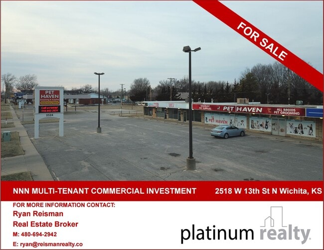
This Property Is For Sale
NEARBY LISTINGS FOR SALE OR LEASE
-
-
No Photo
-
-
-
-
-
-
View all Wichita listings for sale on LoopNet.com
Property Detail
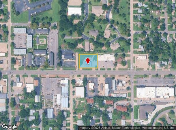
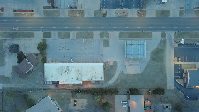
2642 W 13Th St N
Wichita, KS
Rhodes Add
131-12-0-44-01-004.00
W 200 FT LOT 1 RHODES ADD.
Parkinglot
Sedgwick
X
Kansas
20173C0353G
1
2024
0.67 AC
2025
Northwest
001400
Wichita
DEMOGRAPHICS near 2642 W 13Th St N
1 Mile
3 Mile
5 Mile
2024 Total Population
11,188
79,750
195,083
2029 Population
11,406
82,312
201,614
Pop Growth 2024-2029
+ 1.95%
+ 3.21%
+ 3.35%
Average Age
41
39
38
2024 Total Households
5,078
33,915
79,687
HH Growth 2024-2029
+ 2.01%
+ 3.45%
+ 3.49%
Median Household Inc
$50,797
$47,142
$49,410
Avg Household Size
2.10
2.20
2.30
2024 Avg HH Vehicles
2.00
2.00
2.00
Median Home Value
$150,458
$125,816
$132,696
Median Year Built
1958
1960
1962
Nearby Places
Map Layers
Map Styles
 Street
 Aerial
- Restaurants
- Banks
- Shops
- Fitness
- Groceries
PUBLIC TRANSPORTATION
AIRPORT
Wichita Dwight D Eisenhower Ntl
DRIVE
WALK
Distance
Wichita Dwight D Eisenhower Ntl
14 min
6.9 mi
Freight Ports
Tulsa Port Of Catoosa
DRIVE
WALK
Distance
Tulsa Port Of Catoosa
213 min
198.3 mi
Nearby Properties
Address
Land Use
TOTAL SIZE
Lot Size
Zoning
Address
Land Use
TOTAL SIZE
Lot Size
Zoning
468,755 SF
10.41 AC
CBD,LI
Address
Land Use
TOTAL SIZE
Lot Size
Zoning
499,239 SF
18.70 AC
GO
Address
Land Use
TOTAL SIZE
Lot Size
Zoning
216,196 SF
65.60 AC
SF-5
Address
Land Use
TOTAL SIZE
Lot Size
Zoning
515,640 SF
14.49 AC
CBD
Address
Land Use
TOTAL SIZE
Lot Size
Zoning
154,716 SF
12.18 AC
LC
Address
Land Use
TOTAL SIZE
Lot Size
Zoning
386,803 SF
13.33 AC
CBD
Address
Land Use
TOTAL SIZE
Lot Size
Zoning
197,464 SF
4.05 AC
CBD
Address
Land Use
TOTAL SIZE
Lot Size
Zoning
227,462 SF
17.80 AC
TF-3
Address
Land Use
TOTAL SIZE
Lot Size
Zoning
203,580 SF
15.51 AC
B
Address
Land Use
TOTAL SIZE
Lot Size
Zoning
109,743 SF
6.10 AC
CBD
Address
Land Use
TOTAL SIZE
Lot Size
Zoning
225,962 SF
0.24 AC
CBD
Address
Land Use
TOTAL SIZE
Lot Size
Zoning
84,757 SF
1.44 AC
GC
Address
Land Use
TOTAL SIZE
Lot Size
Zoning
328,487 SF
25.95 AC
MF-29
Address
Land Use
TOTAL SIZE
Lot Size
Zoning
180,527 SF
1.93 AC
LI
Address
Land Use
TOTAL SIZE
Lot Size
Zoning
143,110 SF
1.57 AC
LI
Address
Land Use
TOTAL SIZE
Lot Size
Zoning
108,283 SF
14.80 AC
SF-5
Address
Land Use
TOTAL SIZE
Lot Size
Zoning
192,027 SF
117.94 AC
SF-20,GC,L
Address
Land Use
TOTAL SIZE
Lot Size
Zoning
62,535 SF
8.34 AC
B
Address
Land Use
TOTAL SIZE
Lot Size
Zoning
110,839 SF
0.81 AC
CBD
Address
Land Use
TOTAL SIZE
Lot Size
Zoning
169,321 SF
14.61 AC
U
Address
Land Use
TOTAL SIZE
Lot Size
Zoning
79,041 SF
19.51 AC
LC
Address
Land Use
TOTAL SIZE
Lot Size
Zoning
89,057 SF
18.91 AC
B
Address
Land Use
TOTAL SIZE
Lot Size
Zoning
35,097 SF
2.82 AC
U
Address
Land Use
TOTAL SIZE
Lot Size
Zoning
172,486 SF
25.68 AC
SF-5
Address
Land Use
TOTAL SIZE
Lot Size
Zoning
167,923 SF
18.01 AC
SF-5
Address
Land Use
TOTAL SIZE
Lot Size
Zoning
180,598 SF
17.41 AC
SF-5
Address
Land Use
TOTAL SIZE
Lot Size
Zoning
98,677 SF
5.62 AC
TF-3
Address
Land Use
TOTAL SIZE
Lot Size
Zoning
68,468 SF
7.17 AC
B,SF-5,GO
Address
Land Use
TOTAL SIZE
Lot Size
Zoning
64,133 SF
5.93 AC
SF-5
Address
Land Use
TOTAL SIZE
Lot Size
Zoning
85,412 SF
1.21 AC
TF-3
The World's #1 Commercial Real Estate Marketplace
Connect with us
© 2026 CoStar Group
The information above has been obtained from sources believed reliable. While we do not doubt its accuracy we have not verified it and make no guarantee, warranty or representation about it. It is your responsibility to independently confirm its accuracy and completeness. Any projections, opinions, assumptions, or estimates used are for example only and do not represent the current or future performance of the property. The value of this transaction to you depends on tax and other factors which should be evaluated by your tax, financial, and legal advisors. You and your advisors should conduct a careful, independent investigation of the property to determine to your satisfaction the suitability of the property for your needs.