Property Record
2642 Mcilwraith St, Muskegon, MI 49444

NEARBY LISTINGS FOR SALE OR LEASE
Property Detail
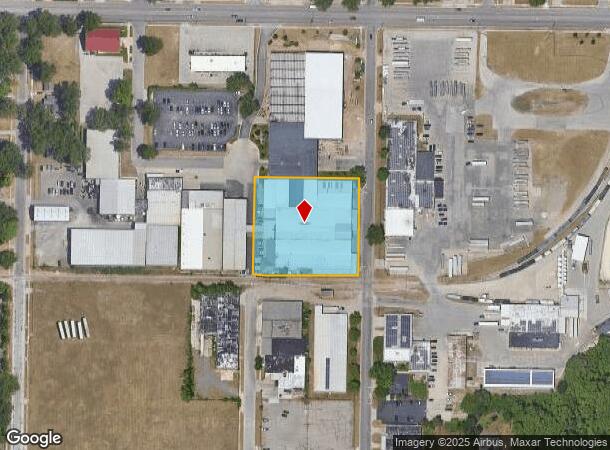
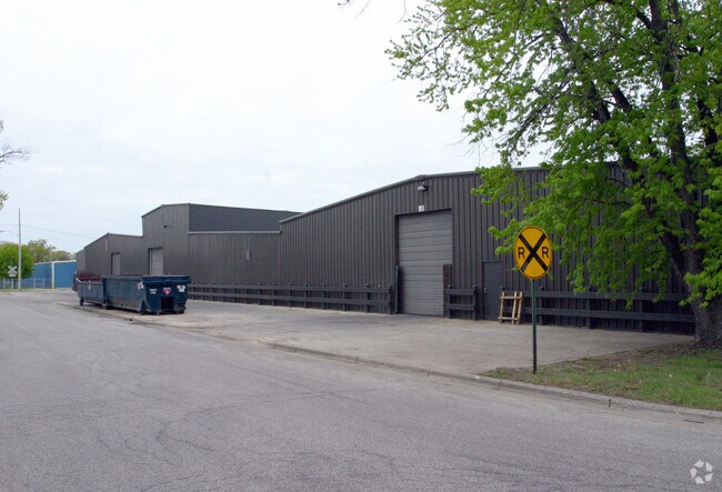
2642 Mcilwraith St
Muskegon, MI
East Manahan Urban Renewal Replat #1
26-251-000-0008-00
CITY OF MUSKEGON HEIGHTS E MANAHAN URBAN RENEWAL REPLAT #1 LOT 8, AND THE ELY PART OF VACATED MCILWRAITH ST LYING BETWEEN BEU
Industrialgeneral
Muskegon
X
Michigan
26121C0278E
8
2024
1.93 AC
2025
Muskegon Heights
004300
West Michigan
65,244 SF
DEMOGRAPHICS near 2642 Mcilwraith St
1 Mile
3 Mile
5 Mile
2024 Total Population
11,680
65,821
104,287
2029 Population
11,978
66,525
105,073
Pop Growth 2024-2029
+ 2.55%
+ 1.07%
+ 0.75%
Average Age
38
39
40
2024 Total Households
3,869
25,330
41,226
HH Growth 2024-2029
+ 2.95%
+ 1.05%
+ 0.74%
Median Household Inc
$32,835
$42,668
$49,993
Avg Household Size
2.50
2.30
2.30
2024 Avg HH Vehicles
1.00
1.00
2.00
Median Home Value
$65,601
$108,756
$141,048
Median Year Built
1949
1955
1961
Nearby Places
Map Layers
Map Styles
 Street
 Aerial
- Restaurants
- Banks
- Shops
- Fitness
- Groceries
Nearby Properties
Address
Land Use
TOTAL SIZE
Lot Size
Zoning
Address
Land Use
TOTAL SIZE
Lot Size
Zoning
490,693 SF
22.70 AC
Address
Land Use
TOTAL SIZE
Lot Size
Zoning
82,643 SF
5.20 AC
MC
Address
Land Use
TOTAL SIZE
Lot Size
Zoning
129,264 SF
R
Address
Land Use
TOTAL SIZE
Lot Size
Zoning
84,452 SF
6.82 AC
PUD
Address
Land Use
TOTAL SIZE
Lot Size
Zoning
249,032 SF
19.18 AC
MFR
Address
Land Use
TOTAL SIZE
Lot Size
Zoning
223,802 SF
22.02 AC
SC-1
Address
Land Use
TOTAL SIZE
Lot Size
Zoning
79,321 SF
4.28 AC
B-3
Address
Land Use
TOTAL SIZE
Lot Size
Zoning
184,130 SF
3.16 AC
FBC-MS
Address
Land Use
TOTAL SIZE
Lot Size
Zoning
41,382 SF
6.20 AC
PUD
Address
Land Use
TOTAL SIZE
Lot Size
Zoning
271,435 SF
13.80 AC
I-2
Address
Land Use
TOTAL SIZE
Lot Size
Zoning
116,657 SF
1.60 AC
FBC-UR
Address
Land Use
TOTAL SIZE
Lot Size
Zoning
219,341 SF
18.55 AC
C-SE
Address
Land Use
TOTAL SIZE
Lot Size
Zoning
79,321 SF
5 AC
FBC-MS
Address
Land Use
TOTAL SIZE
Lot Size
Zoning
80,572 SF
12.98 AC
I-1
Address
Land Use
TOTAL SIZE
Lot Size
Zoning
194,708 SF
15.59 AC
C-2
Address
Land Use
TOTAL SIZE
Lot Size
Zoning
142,000 SF
1.60 AC
FBC-DT
Address
Land Use
TOTAL SIZE
Lot Size
Zoning
19,171 SF
6.55 AC
MC
Address
Land Use
TOTAL SIZE
Lot Size
Zoning
350,378 SF
21.50 AC
GI
Address
Land Use
TOTAL SIZE
Lot Size
Zoning
71,329 SF
I-2
Address
Land Use
TOTAL SIZE
Lot Size
Zoning
2,044 SF
4.10 AC
RT
Address
Land Use
TOTAL SIZE
Lot Size
Zoning
82,895 SF
13.09 AC
SC-1
Address
Land Use
TOTAL SIZE
Lot Size
Zoning
85,577 SF
8.72 AC
PUD
Address
Land Use
TOTAL SIZE
Lot Size
Zoning
163,658 SF
14.70 AC
RM-1
Address
Land Use
TOTAL SIZE
Lot Size
Zoning
33,750 SF
R
Address
Land Use
TOTAL SIZE
Lot Size
Zoning
241,589 SF
14.60 AC
I-2
Address
Land Use
TOTAL SIZE
Lot Size
Zoning
180,144 SF
3.29 AC
RM-1
Address
Land Use
TOTAL SIZE
Lot Size
Zoning
68,782 SF
10.52 AC
C-2
Address
Land Use
TOTAL SIZE
Lot Size
Zoning
121,466 SF
11.65 AC
SC-1
Address
Land Use
TOTAL SIZE
Lot Size
Zoning
143,193 SF
13.82 AC
SC-1
Address
Land Use
TOTAL SIZE
Lot Size
Zoning
122.75 AC
R-2
The World's #1 Commercial Real Estate Marketplace
Connect with us
© 2025 CoStar Group
The information above has been obtained from sources believed reliable. While we do not doubt its accuracy we have not verified it and make no guarantee, warranty or representation about it. It is your responsibility to independently confirm its accuracy and completeness. Any projections, opinions, assumptions, or estimates used are for example only and do not represent the current or future performance of the property. The value of this transaction to you depends on tax and other factors which should be evaluated by your tax, financial, and legal advisors. You and your advisors should conduct a careful, independent investigation of the property to determine to your satisfaction the suitability of the property for your needs.