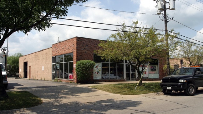
Property Record
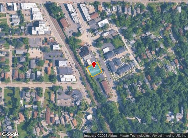
2642 Waukegan Ave, Highland Park, IL 60035
NEARBY LISTINGS FOR SALE OR LEASE
Property Detail
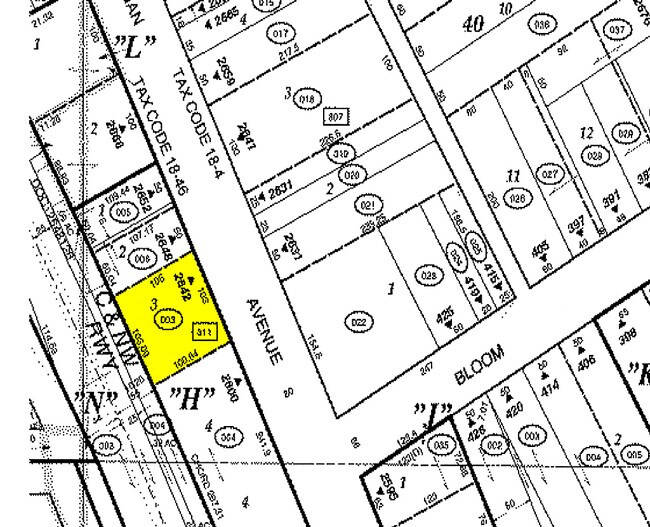
2642 Waukegan Ave
Chicago-Naperville-Elgin, IL-IN-WI
Highland Apt Sub
16-14-311-003
HIGHLAND APT SUB LOT 3
Commercialacreage
Lake
X
Illinois
17097C0283L
3
2023
0.25 AC
2024
Central North
865501
Chicago
DEMOGRAPHICS near 2642 Waukegan Ave
1 Mile
3 Mile
5 Mile
2024 Total Population
10,045
43,262
93,479
2029 Population
9,831
42,773
92,311
Pop Growth 2024-2029
(2.13%)
(1.13%)
(1.25%)
Average Age
41
43
43
2024 Total Households
3,772
15,947
34,261
HH Growth 2024-2029
(2.12%)
(1.13%)
(1.37%)
Median Household Inc
$98,202
$154,077
$155,333
Avg Household Size
2.60
2.60
2.60
2024 Avg HH Vehicles
2.00
2.00
2.00
Median Home Value
$463,270
$621,469
$653,425
Median Year Built
1958
1964
1969
Nearby Places
- Restaurants
- Banks
- Shops
- Fitness
- Groceries
PUBLIC TRANSPORTATION
COMMUTER RAIL
Highwood Station (Union Pacific North Line - Northeast Illinois Regional Commuter Railroad (Metra))
DRIVE
WALK
Distance
Highwood Station (Union Pacific North Line - Northeast Illinois Regional Commuter Railroad (Metra))
0 min
5 min
0.3 mi
Highland Park Station (Union Pacific North Line - Northeast Illinois Regional Commuter Railroad (Metra))
DRIVE
WALK
Distance
Highland Park Station (Union Pacific North Line - Northeast Illinois Regional Commuter Railroad (Metra))
3 min
1.5 mi
AIRPORT
Chicago O'Hare International
DRIVE
WALK
Distance
Chicago O'Hare International
32 min
22.4 mi
Chicago Midway International
DRIVE
WALK
Distance
Chicago Midway International
49 min
33.3 mi
Freight Ports
Port Milwaukee
DRIVE
WALK
Distance
Port Milwaukee
72 min
60.7 mi
Nearby Properties
Address
Land Use
TOTAL SIZE
Lot Size
Zoning
Address
Land Use
TOTAL SIZE
Lot Size
Zoning
244,300 SF
2.46 AC
Address
Land Use
TOTAL SIZE
Lot Size
Zoning
806,580 SF
7.64 AC
Address
Land Use
TOTAL SIZE
Lot Size
Zoning
0.57 AC
Address
Land Use
TOTAL SIZE
Lot Size
Zoning
78.54 AC
Address
Land Use
TOTAL SIZE
Lot Size
Zoning
129,900 SF
0.76 AC
Address
Land Use
TOTAL SIZE
Lot Size
Zoning
419,812 SF
13.88 AC
Address
Land Use
TOTAL SIZE
Lot Size
Zoning
191,025 SF
15.66 AC
Address
Land Use
TOTAL SIZE
Lot Size
Zoning
510,213 SF
1.27 AC
Address
Land Use
TOTAL SIZE
Lot Size
Zoning
74,599 SF
9.16 AC
Address
Land Use
TOTAL SIZE
Lot Size
Zoning
79,073 SF
8.70 AC
Address
Land Use
TOTAL SIZE
Lot Size
Zoning
3,896 SF
4.36 AC
Address
Land Use
TOTAL SIZE
Lot Size
Zoning
0.46 AC
Address
Land Use
TOTAL SIZE
Lot Size
Zoning
231,969 SF
1.86 AC
Address
Land Use
TOTAL SIZE
Lot Size
Zoning
131,219 SF
2.58 AC
Address
Land Use
TOTAL SIZE
Lot Size
Zoning
250,096 SF
2.16 AC
Address
Land Use
TOTAL SIZE
Lot Size
Zoning
45,091 SF
1.81 AC
Address
Land Use
TOTAL SIZE
Lot Size
Zoning
Address
Land Use
TOTAL SIZE
Lot Size
Zoning
127,191 SF
76.51 AC
Address
Land Use
TOTAL SIZE
Lot Size
Zoning
313,794 SF
6.91 AC
Address
Land Use
TOTAL SIZE
Lot Size
Zoning
74,190 SF
1.79 AC
Address
Land Use
TOTAL SIZE
Lot Size
Zoning
40,820 SF
5.79 AC
Address
Land Use
TOTAL SIZE
Lot Size
Zoning
94,920 SF
2.25 AC
Address
Land Use
TOTAL SIZE
Lot Size
Zoning
75,528 SF
7.83 AC
Address
Land Use
TOTAL SIZE
Lot Size
Zoning
136,929 SF
15.35 AC
Address
Land Use
TOTAL SIZE
Lot Size
Zoning
49,226 SF
0.65 AC
Address
Land Use
TOTAL SIZE
Lot Size
Zoning
71,948 SF
13.39 AC
Address
Land Use
TOTAL SIZE
Lot Size
Zoning
110,355 SF
10.12 AC
Address
Land Use
TOTAL SIZE
Lot Size
Zoning
67,900 SF
0.96 AC
Address
Land Use
TOTAL SIZE
Lot Size
Zoning
205,616 SF
2.79 AC
Address
Land Use
TOTAL SIZE
Lot Size
Zoning
290,040 SF
2.91 AC
The World's #1 Commercial Real Estate Marketplace
Connect with us
© 2025 CoStar Group
The information above has been obtained from sources believed reliable. While we do not doubt its accuracy we have not verified it and make no guarantee, warranty or representation about it. It is your responsibility to independently confirm its accuracy and completeness. Any projections, opinions, assumptions, or estimates used are for example only and do not represent the current or future performance of the property. The value of this transaction to you depends on tax and other factors which should be evaluated by your tax, financial, and legal advisors. You and your advisors should conduct a careful, independent investigation of the property to determine to your satisfaction the suitability of the property for your needs.