Property Record
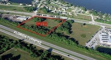
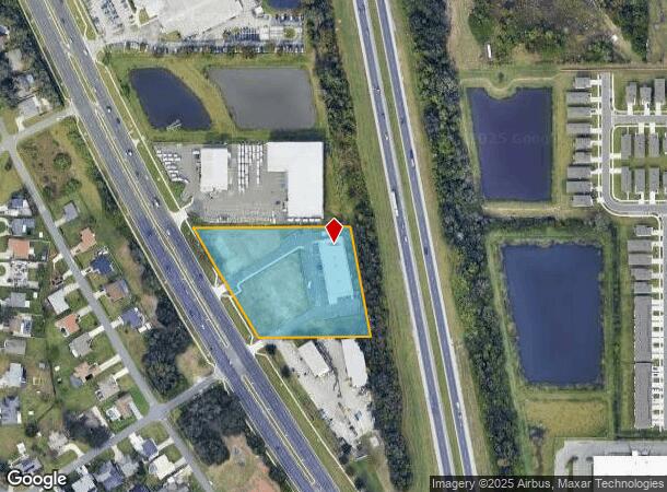
2631 E Irlo Bronson Memorial Hwy, Kissimmee, FL 34744
NEARBY LISTINGS FOR SALE OR LEASE
Property Detail
2631 E Irlo Bronson Memorial Hwy
Orlando-Kissimmee-Sanford, FL
Acreage & Unrec
32-25-30-0000-0024-0000
FROM SE COR OF SW 1/4 SEC 32 RUN N ALONG E LINE SW 1/4 2244.75 FT TO INT OF W LINE FLA TURNPIKE & US 441, RUN N 10 DEG W ALONG W R/W TNPK 716.80 FT TO POB CONT N 10 DEG W 351.04 FT, W 489.76 FT TO ELY R/W US 441, SELY ALONG R/W 400 FT, E 350.18 FT TO
Storebuilding
Osceola
X
Florida
12095C0650G
24
2024
3.37 AC
2025
St Cloud
042902
Orlando
12,336 SF
DEMOGRAPHICS near 2631 E Irlo Bronson Memorial Hwy
1 Mile
3 Mile
5 Mile
2024 Total Population
4,952
45,226
113,703
2029 Population
5,935
53,933
135,285
Pop Growth 2024-2029
+ 19.85%
+ 19.25%
+ 18.98%
Average Age
36
38
39
2024 Total Households
1,645
15,283
38,062
HH Growth 2024-2029
+ 19.94%
+ 19.15%
+ 18.83%
Median Household Inc
$40,857
$52,395
$58,110
Avg Household Size
3.00
2.90
2.90
2024 Avg HH Vehicles
2.00
2.00
2.00
Median Home Value
$319,047
$279,134
$266,491
Median Year Built
2005
2001
1995
Nearby Places
Map Layers
Map Styles
 Street
 Aerial
- Restaurants
- Banks
- Shops
- Fitness
- Groceries
PUBLIC TRANSPORTATION
AIRPORT
Orlando International
DRIVE
WALK
Distance
Orlando International
33 min
25.6 mi
Freight Ports
Port Canaveral
DRIVE
WALK
Distance
Port Canaveral
79 min
67.3 mi
SALE & LEASE HISTORY
LISTING DATE
SALE/LEASE

Aug 30, 2019
For Lease
Nearby Properties
Address
Land Use
TOTAL SIZE
Lot Size
Zoning
Address
Land Use
TOTAL SIZE
Lot Size
Zoning
457,374 SF
30.93 AC
OCT
Address
Land Use
TOTAL SIZE
Lot Size
Zoning
402,010 SF
22.33 AC
OCR
Address
Land Use
TOTAL SIZE
Lot Size
Zoning
343,107 SF
16.26 AC
OEC
Address
Land Use
TOTAL SIZE
Lot Size
Zoning
142,570 SF
20.16 AC
OPD
Address
Land Use
TOTAL SIZE
Lot Size
Zoning
351,537 SF
44.58 AC
OPD
Address
Land Use
TOTAL SIZE
Lot Size
Zoning
275,507 SF
22.19 AC
RM-2
Address
Land Use
TOTAL SIZE
Lot Size
Zoning
437,037 SF
34.76 AC
OPUD
Address
Land Use
TOTAL SIZE
Lot Size
Zoning
188,719 SF
10.81 AC
Address
Land Use
TOTAL SIZE
Lot Size
Zoning
203,711 SF
10.27 AC
Address
Land Use
TOTAL SIZE
Lot Size
Zoning
374,081 SF
36.66 AC
KRC1
Address
Land Use
TOTAL SIZE
Lot Size
Zoning
187,302 SF
20.85 AC
Address
Land Use
TOTAL SIZE
Lot Size
Zoning
343,593 SF
49.46 AC
OAC
Address
Land Use
TOTAL SIZE
Lot Size
Zoning
145,028 SF
6.85 AC
Address
Land Use
TOTAL SIZE
Lot Size
Zoning
57,939 SF
80.04 AC
OPD
Address
Land Use
TOTAL SIZE
Lot Size
Zoning
309,075 SF
16.94 AC
OPUD
Address
Land Use
TOTAL SIZE
Lot Size
Zoning
304,494 SF
15.67 AC
Address
Land Use
TOTAL SIZE
Lot Size
Zoning
258,588 SF
119.70 AC
OAC
Address
Land Use
TOTAL SIZE
Lot Size
Zoning
118,121 SF
237.16 AC
SP
Address
Land Use
TOTAL SIZE
Lot Size
Zoning
208,677 SF
12.64 AC
Address
Land Use
TOTAL SIZE
Lot Size
Zoning
73,910 SF
4.61 AC
OCT
Address
Land Use
TOTAL SIZE
Lot Size
Zoning
113,079 SF
8.96 AC
OCT
Address
Land Use
TOTAL SIZE
Lot Size
Zoning
198,144 SF
12.18 AC
SR4
Address
Land Use
TOTAL SIZE
Lot Size
Zoning
82,614 SF
9.89 AC
SHB
Address
Land Use
TOTAL SIZE
Lot Size
Zoning
106,078 SF
15.04 AC
SP
Address
Land Use
TOTAL SIZE
Lot Size
Zoning
63,524 SF
10.88 AC
OCR
Address
Land Use
TOTAL SIZE
Lot Size
Zoning
42,528 SF
17 AC
ORM3
Address
Land Use
TOTAL SIZE
Lot Size
Zoning
50,025 SF
4.45 AC
SP
Address
Land Use
TOTAL SIZE
Lot Size
Zoning
79,854 SF
8.89 AC
SHB
Address
Land Use
TOTAL SIZE
Lot Size
Zoning
113,362 SF
40.78 AC
OPUD
Address
Land Use
TOTAL SIZE
Lot Size
Zoning
66,171 SF
8.42 AC
OCR
The World's #1 Commercial Real Estate Marketplace
Connect with us
© 2025 CoStar Group
The information above has been obtained from sources believed reliable. While we do not doubt its accuracy we have not verified it and make no guarantee, warranty or representation about it. It is your responsibility to independently confirm its accuracy and completeness. Any projections, opinions, assumptions, or estimates used are for example only and do not represent the current or future performance of the property. The value of this transaction to you depends on tax and other factors which should be evaluated by your tax, financial, and legal advisors. You and your advisors should conduct a careful, independent investigation of the property to determine to your satisfaction the suitability of the property for your needs.