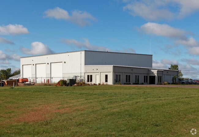
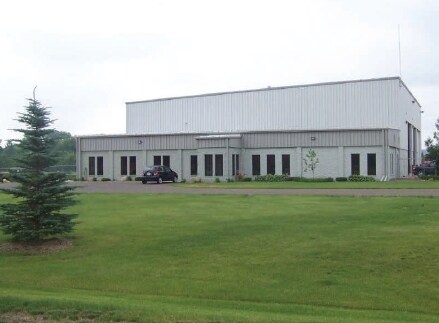
Property Record
2644 61St Ave, Osceola, WI 54020

NEARBY LISTINGS FOR SALE OR LEASE
Property Detail
2644 61St Ave
022-01210-0800
LOT 8 PRAIRIE VIEW BUSINESS CENTER LOC IN SW SE 34-33-19 & NW NE 3-32-19
Commercialnec
Polk
X
Wisconsin
27025C0425D
8
2024
9.10 AC
2024
Wisconsin North Area
960800
Other Market Areas
DEMOGRAPHICS near 2644 61St Ave
1 Mile
3 Mile
5 Mile
2024 Total Population
92
3,921
7,390
2029 Population
95
4,023
7,632
Pop Growth 2024-2029
+ 3.26%
+ 2.60%
+ 3.27%
Average Age
41
41
42
2024 Total Households
35
1,658
2,999
HH Growth 2024-2029
+ 2.86%
+ 2.41%
+ 3.07%
Median Household Inc
$92,856
$67,602
$79,183
Avg Household Size
2.50
2.30
2.40
2024 Avg HH Vehicles
3.00
2.00
2.00
Median Home Value
$273,076
$225,242
$264,890
Median Year Built
1995
1984
1987
Nearby Places
Map Layers
Map Styles
 Street
 Aerial
- Restaurants
- Banks
- Shops
- Fitness
- Groceries
SALE & LEASE HISTORY
LISTING DATE
SALE/LEASE

Sep 24, 2016
For Sale
Sep 23, 2016
For Sale
Apr 07, 2017
For Sale
Nearby Properties
Address
Land Use
TOTAL SIZE
Lot Size
Zoning
Address
Land Use
TOTAL SIZE
Lot Size
Zoning
Address
Land Use
TOTAL SIZE
Lot Size
Zoning
5.08 AC
Address
Land Use
TOTAL SIZE
Lot Size
Zoning
4.11 AC
Address
Land Use
TOTAL SIZE
Lot Size
Zoning
6.30 AC
Address
Land Use
TOTAL SIZE
Lot Size
Zoning
Address
Land Use
TOTAL SIZE
Lot Size
Zoning
8.97 AC
Address
Land Use
TOTAL SIZE
Lot Size
Zoning
Address
Land Use
TOTAL SIZE
Lot Size
Zoning
0.25 AC
Address
Land Use
TOTAL SIZE
Lot Size
Zoning
1.08 AC
Address
Land Use
TOTAL SIZE
Lot Size
Zoning
6.51 AC
Address
Land Use
TOTAL SIZE
Lot Size
Zoning
4.76 AC
Address
Land Use
TOTAL SIZE
Lot Size
Zoning
1.89 AC
Address
Land Use
TOTAL SIZE
Lot Size
Zoning
15.62 AC
Address
Land Use
TOTAL SIZE
Lot Size
Zoning
1.26 AC
Address
Land Use
TOTAL SIZE
Lot Size
Zoning
39.57 AC
Address
Land Use
TOTAL SIZE
Lot Size
Zoning
27.26 AC
Address
Land Use
TOTAL SIZE
Lot Size
Zoning
2.51 AC
Address
Land Use
TOTAL SIZE
Lot Size
Zoning
Address
Land Use
TOTAL SIZE
Lot Size
Zoning
10.05 AC
Address
Land Use
TOTAL SIZE
Lot Size
Zoning
19.40 AC
Address
Land Use
TOTAL SIZE
Lot Size
Zoning
4.84 AC
Address
Land Use
TOTAL SIZE
Lot Size
Zoning
1.17 AC
Address
Land Use
TOTAL SIZE
Lot Size
Zoning
5.08 AC
Address
Land Use
TOTAL SIZE
Lot Size
Zoning
40.11 AC
Address
Land Use
TOTAL SIZE
Lot Size
Zoning
7.41 AC
Address
Land Use
TOTAL SIZE
Lot Size
Zoning
28.80 AC
Address
Land Use
TOTAL SIZE
Lot Size
Zoning
0.87 AC
Address
Land Use
TOTAL SIZE
Lot Size
Zoning
1.76 AC
Address
Land Use
TOTAL SIZE
Lot Size
Zoning
12.83 AC
The World's #1 Commercial Real Estate Marketplace
Connect with us
© 2026 CoStar Group
The information above has been obtained from sources believed reliable. While we do not doubt its accuracy we have not verified it and make no guarantee, warranty or representation about it. It is your responsibility to independently confirm its accuracy and completeness. Any projections, opinions, assumptions, or estimates used are for example only and do not represent the current or future performance of the property. The value of this transaction to you depends on tax and other factors which should be evaluated by your tax, financial, and legal advisors. You and your advisors should conduct a careful, independent investigation of the property to determine to your satisfaction the suitability of the property for your needs.