Property Record
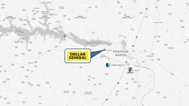
2645 Bolling Rd, Roanoke Rapids, NC 27870

Save to a Folder
{{folder.Name}}
{{folder.ListingIds.length}} Properties
{{folder.ListingIds.length}} Property
Create a New Folder
Property Detail
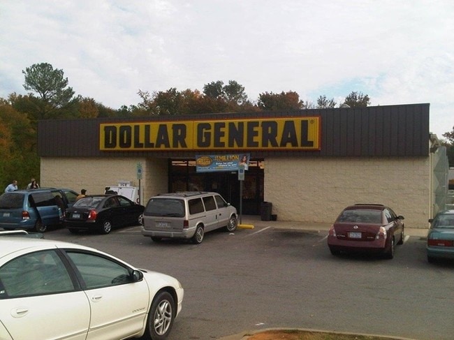
2645 Bolling Rd
09-19831
2645 BOLLING RD
Wholesaleoutletdiscountstore
Halifax
RRB4
North Carolina
B and X Area of moderate flood hazard, usually the area between the limits of the 100-year and 500-year floods.
1.14 AC
2025
North Carolina Northeast Area
2025
Other Market Areas
930501
Roanoke Rapids, NC
8,946 SF
NEARBY LISTINGS FOR SALE OR LEASE
-
-
View all Roanoke Rapids listings for sale on LoopNet.com
DEMOGRAPHICS near 2645 Bolling Rd
1 mile
3 mile
5 mile
2025 Total Population
2,387
15,674
24,461
2030 Population
2,269
15,146
23,601
Pop Growth 2025-2030
(4.94%)
(3.37%)
(3.52%)
Average Age
40
41
42
2025 Total Households
968
6,483
10,541
HH Growth 2025-2030
(4.96%)
(3.38%)
(3.58%)
Median Household Inc
$49,493
$52,111
$48,976
Avg Household Size
2.40
2.30
2.30
2025 Avg HH Vehicles
2.00
2.00
2.00
Median Home Value
$143,220
$124,565
$129,403
Median Year Built
1984
1970
1978
Nearby Places
Map Layers
Map Styles
 Street
 Aerial
Layers
 Traffic
 Biking
Places
Listings with unknown addresses are not visible on the map
- Restaurants
- Banks
- Shops
- Fitness
- Groceries
SALE & LEASE HISTORY
LISTING DATE
SALE/LEASE

Sep 16, 2021
For Sale
Oct 20, 2022
For Sale
May 21, 2019
For Sale
Apr 07, 2017
For Sale
Nearby Properties
Address
Land Use
TOTAL SIZE
Lot Size
Zoning
Address
Land Use
TOTAL SIZE
Lot Size
Zoning
97,735 SF
21.37 AC
RRR8
Address
Land Use
TOTAL SIZE
Lot Size
Zoning
94,328 SF
26.40 AC
RRR8
Address
Land Use
TOTAL SIZE
Lot Size
Zoning
26,530 SF
196.49 AC
RRI2
Address
Land Use
TOTAL SIZE
Lot Size
Zoning
60,043 SF
1.58 AC
RRR6
Address
Land Use
TOTAL SIZE
Lot Size
Zoning
38,176 SF
6.20 AC
RRR6
Address
Land Use
TOTAL SIZE
Lot Size
Zoning
75,353 SF
10 AC
RRR6
Address
Land Use
TOTAL SIZE
Lot Size
Zoning
14,400 SF
4.83 AC
RRI2
Address
Land Use
TOTAL SIZE
Lot Size
Zoning
10,114 SF
4.45 AC
RRR6
Address
Land Use
TOTAL SIZE
Lot Size
Zoning
6,840 SF
1.82 AC
RRR20
Address
Land Use
TOTAL SIZE
Lot Size
Zoning
10,920 SF
1.92 AC
RRR8
Address
Land Use
TOTAL SIZE
Lot Size
Zoning
25,074 SF
0.32 AC
RRB2
Address
Land Use
TOTAL SIZE
Lot Size
Zoning
5,406 SF
15 AC
RRR
Address
Land Use
TOTAL SIZE
Lot Size
Zoning
2,760 SF
6.17 AC
RRR6
Address
Land Use
TOTAL SIZE
Lot Size
Zoning
16,281 SF
16.56 AC
RRR8
Address
Land Use
TOTAL SIZE
Lot Size
Zoning
43,148 SF
1.83 AC
RRB
Address
Land Use
TOTAL SIZE
Lot Size
Zoning
43,767 SF
4.99 AC
RRB4
Address
Land Use
TOTAL SIZE
Lot Size
Zoning
569,998 SF
35.45 AC
RRI2
Address
Land Use
TOTAL SIZE
Lot Size
Zoning
26,136 SF
6.15 AC
RRR
Address
Land Use
TOTAL SIZE
Lot Size
Zoning
20,020 SF
5.99 AC
RRR
Address
Land Use
TOTAL SIZE
Lot Size
Zoning
8,054 SF
3.68 AC
RRR6
Address
Land Use
TOTAL SIZE
Lot Size
Zoning
24,783 SF
1.03 AC
RRR6
Address
Land Use
TOTAL SIZE
Lot Size
Zoning
3,960 SF
Address
Land Use
TOTAL SIZE
Lot Size
Zoning
21,982 SF
0.72 AC
RRB1
Address
Land Use
TOTAL SIZE
Lot Size
Zoning
10,436 SF
4.92 AC
RRR6
Address
Land Use
TOTAL SIZE
Lot Size
Zoning
11,495 SF
1.84 AC
RRB4
Address
Land Use
TOTAL SIZE
Lot Size
Zoning
69,604 SF
5.29 AC
RRB4
Address
Land Use
TOTAL SIZE
Lot Size
Zoning
17,340 SF
28.05 AC
Address
Land Use
TOTAL SIZE
Lot Size
Zoning
16,180 SF
4.13 AC
RRR8
Address
Land Use
TOTAL SIZE
Lot Size
Zoning
1,122 SF
236.80 AC
Address
Land Use
TOTAL SIZE
Lot Size
Zoning
69,353 SF
7.11 AC
RRI2
The World's #1 Commercial Real Estate Marketplace
Connect with us
© 2026 CoStar Group
The information above has been obtained from sources believed reliable. While we do not doubt its accuracy we have not verified it and make no guarantee, warranty or representation about it. It is your responsibility to independently confirm its accuracy and completeness. Any projections, opinions, assumptions, or estimates used are for example only and do not represent the current or future performance of the property. The value of this transaction to you depends on tax and other factors which should be evaluated by your tax, financial, and legal advisors. You and your advisors should conduct a careful, independent investigation of the property to determine to your satisfaction the suitability of the property for your needs.