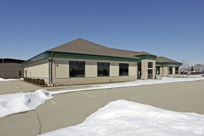
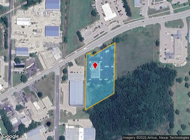
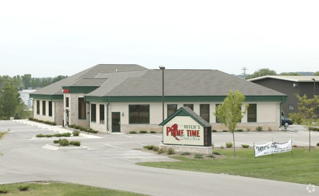
Property Record
2645 Main St, East Troy, WI 53120

NEARBY LISTINGS FOR SALE OR LEASE
Property Detail
2645 Main St
Whitewater-Elkhorn, WI
Certified Survey Map No 839
RA83900002
LOT 2 CSM 839 & PT LOT 1 CSM 1391 DESC AS: COM NW COR LOT 2 CSM 839, S0D56'25"W 509.33', N59D59'30"E 116.60', N59D58' 36"E 19
Commercialnec
Walworth
X
Wisconsin
55133C0425G
2
2024
2.87 AC
2024
Walworth East
000103
Milwaukee/Madison
DEMOGRAPHICS near 2645 Main St
1 Mile
3 Mile
5 Mile
2024 Total Population
3,240
6,516
9,559
2029 Population
3,191
6,398
9,401
Pop Growth 2024-2029
(1.51%)
(1.81%)
(1.65%)
Average Age
41
42
43
2024 Total Households
1,308
2,664
3,847
HH Growth 2024-2029
(1.83%)
(2.18%)
(1.98%)
Median Household Inc
$78,589
$82,593
$86,864
Avg Household Size
2.50
2.40
2.40
2024 Avg HH Vehicles
2.00
2.00
2.00
Median Home Value
$243,052
$270,120
$283,397
Median Year Built
1977
1978
1977
Nearby Places
Map Layers
Map Styles
 Street
 Aerial
- Restaurants
- Banks
- Shops
- Fitness
- Groceries
PUBLIC TRANSPORTATION
AIRPORT
General Mitchell International
DRIVE
WALK
Distance
General Mitchell International
41 min
30.8 mi
Freight Ports
Port Milwaukee
DRIVE
WALK
Distance
Port Milwaukee
40 min
32.7 mi
SALE & LEASE HISTORY
LISTING DATE
SALE/LEASE

Sep 24, 2016
For Sale
Feb 17, 2017
For Sale
Nearby Properties
Address
Land Use
TOTAL SIZE
Lot Size
Zoning
Address
Land Use
TOTAL SIZE
Lot Size
Zoning
17.94 AC
Address
Land Use
TOTAL SIZE
Lot Size
Zoning
Address
Land Use
TOTAL SIZE
Lot Size
Zoning
48.90 AC
Address
Land Use
TOTAL SIZE
Lot Size
Zoning
6.14 AC
Address
Land Use
TOTAL SIZE
Lot Size
Zoning
55.74 AC
Address
Land Use
TOTAL SIZE
Lot Size
Zoning
6.28 AC
Address
Land Use
TOTAL SIZE
Lot Size
Zoning
Address
Land Use
TOTAL SIZE
Lot Size
Zoning
17.19 AC
Address
Land Use
TOTAL SIZE
Lot Size
Zoning
23.46 AC
Address
Land Use
TOTAL SIZE
Lot Size
Zoning
73.72 AC
Address
Land Use
TOTAL SIZE
Lot Size
Zoning
Address
Land Use
TOTAL SIZE
Lot Size
Zoning
3.13 AC
Address
Land Use
TOTAL SIZE
Lot Size
Zoning
9.66 AC
Address
Land Use
TOTAL SIZE
Lot Size
Zoning
7.49 AC
Address
Land Use
TOTAL SIZE
Lot Size
Zoning
Address
Land Use
TOTAL SIZE
Lot Size
Zoning
1.46 AC
Address
Land Use
TOTAL SIZE
Lot Size
Zoning
0.61 AC
Address
Land Use
TOTAL SIZE
Lot Size
Zoning
Address
Land Use
TOTAL SIZE
Lot Size
Zoning
4.48 AC
Address
Land Use
TOTAL SIZE
Lot Size
Zoning
5.82 AC
Address
Land Use
TOTAL SIZE
Lot Size
Zoning
5.77 AC
Address
Land Use
TOTAL SIZE
Lot Size
Zoning
2.37 AC
Address
Land Use
TOTAL SIZE
Lot Size
Zoning
10.55 AC
M1
Address
Land Use
TOTAL SIZE
Lot Size
Zoning
8.38 AC
Address
Land Use
TOTAL SIZE
Lot Size
Zoning
4.12 AC
Address
Land Use
TOTAL SIZE
Lot Size
Zoning
Address
Land Use
TOTAL SIZE
Lot Size
Zoning
2.55 AC
Address
Land Use
TOTAL SIZE
Lot Size
Zoning
Address
Land Use
TOTAL SIZE
Lot Size
Zoning
17.24 AC
Address
Land Use
TOTAL SIZE
Lot Size
Zoning
0.79 AC
The World's #1 Commercial Real Estate Marketplace
Connect with us
© 2025 CoStar Group
The information above has been obtained from sources believed reliable. While we do not doubt its accuracy we have not verified it and make no guarantee, warranty or representation about it. It is your responsibility to independently confirm its accuracy and completeness. Any projections, opinions, assumptions, or estimates used are for example only and do not represent the current or future performance of the property. The value of this transaction to you depends on tax and other factors which should be evaluated by your tax, financial, and legal advisors. You and your advisors should conduct a careful, independent investigation of the property to determine to your satisfaction the suitability of the property for your needs.