Property Record
2646 Westbend Pw Pkwy, New Orleans, LA 70114
This Property Is For Sale
NEARBY LISTINGS FOR SALE OR LEASE
Property Detail
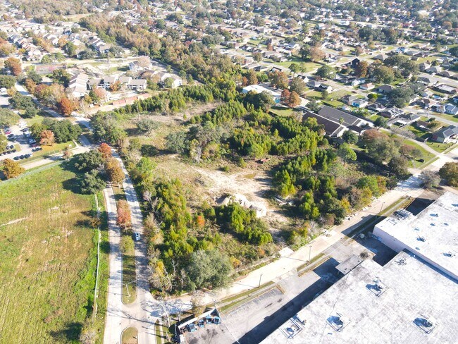
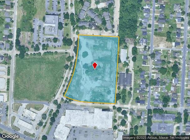
2646 Westbend Pw Pkwy
New Orleans-Metairie, LA
Westbend Park
5-13-7-107-01
PT TUNISBURG-PT CAZELAR PLT PARCEL NO 2-A 339,249.03 SQ FT OR 7.79 ACRES 2646 WESTBEND PARKWAY
Residentialacreage
Orleans
AE
Louisiana
22051C0220F
2-a
2025
7.79 AC
2025
Westbank
000602
New Orleans/Metairie/Kenner
DEMOGRAPHICS near 2646 Westbend Pw Pkwy
1 Mile
3 Mile
5 Mile
2024 Total Population
16,279
103,052
263,496
2029 Population
15,343
99,498
257,446
Pop Growth 2024-2029
(5.75%)
(3.45%)
(2.30%)
Average Age
40
40
40
2024 Total Households
6,607
41,585
114,500
HH Growth 2024-2029
(6.27%)
(3.63%)
(2.21%)
Median Household Inc
$32,202
$46,343
$46,861
Avg Household Size
2.40
2.40
2.20
2024 Avg HH Vehicles
1.00
1.00
1.00
Median Home Value
$181,283
$198,547
$230,377
Median Year Built
1971
1969
1964
Nearby Places
- Restaurants
- Banks
- Shops
- Fitness
- Groceries
PUBLIC TRANSPORTATION
COMMUTER RAIL
New Orleans Union Passenger Terminal (City of New Orleans - Amtrak, Crescent - Amtrak, Sunset Limited - Amtrak)
DRIVE
WALK
Distance
New Orleans Union Passenger Terminal (City of New Orleans - Amtrak, Crescent - Amtrak, Sunset Limited - Amtrak)
8 min
4.5 mi
AIRPORT
Louis Armstrong New Orleans International
DRIVE
WALK
Distance
Louis Armstrong New Orleans International
27 min
18.9 mi
Freight Ports
Port of New Orleans
DRIVE
WALK
Distance
Port of New Orleans
13 min
5.2 mi
Nearby Properties
Address
Land Use
TOTAL SIZE
Lot Size
Zoning
Address
Land Use
TOTAL SIZE
Lot Size
Zoning
44.43 AC
CBD-4
Address
Land Use
TOTAL SIZE
Lot Size
Zoning
18.31 AC
CBD-4
Address
Land Use
TOTAL SIZE
Lot Size
Zoning
6.64 AC
Address
Land Use
TOTAL SIZE
Lot Size
Zoning
0.12 AC
Address
Land Use
TOTAL SIZE
Lot Size
Zoning
30.63 AC
Address
Land Use
TOTAL SIZE
Lot Size
Zoning
22.17 AC
Address
Land Use
TOTAL SIZE
Lot Size
Zoning
512,729 SF
6.60 AC
Address
Land Use
TOTAL SIZE
Lot Size
Zoning
202,291 SF
4.04 AC
HU-RD2
Address
Land Use
TOTAL SIZE
Lot Size
Zoning
25.26 AC
Address
Land Use
TOTAL SIZE
Lot Size
Zoning
85,568 SF
23.74 AC
MU-1
Address
Land Use
TOTAL SIZE
Lot Size
Zoning
222,425 SF
1.11 AC
CBD-6
Address
Land Use
TOTAL SIZE
Lot Size
Zoning
109,688 SF
8.77 AC
S-RM1
Address
Land Use
TOTAL SIZE
Lot Size
Zoning
23.90 AC
Address
Land Use
TOTAL SIZE
Lot Size
Zoning
188,935 SF
1.12 AC
CBD-6
Address
Land Use
TOTAL SIZE
Lot Size
Zoning
1.91 AC
HU-MU
Address
Land Use
TOTAL SIZE
Lot Size
Zoning
14.40 AC
Address
Land Use
TOTAL SIZE
Lot Size
Zoning
140,772 SF
9.01 AC
S-RS
Address
Land Use
TOTAL SIZE
Lot Size
Zoning
332,393 SF
6.39 AC
CBD-4
Address
Land Use
TOTAL SIZE
Lot Size
Zoning
Address
Land Use
TOTAL SIZE
Lot Size
Zoning
207,220 SF
0.40 AC
CBD-2
Address
Land Use
TOTAL SIZE
Lot Size
Zoning
Address
Land Use
TOTAL SIZE
Lot Size
Zoning
6.94 AC
CBD-4
Address
Land Use
TOTAL SIZE
Lot Size
Zoning
0.16 AC
Address
Land Use
TOTAL SIZE
Lot Size
Zoning
0.19 AC
Address
Land Use
TOTAL SIZE
Lot Size
Zoning
10.14 AC
Address
Land Use
TOTAL SIZE
Lot Size
Zoning
0.78 AC
Address
Land Use
TOTAL SIZE
Lot Size
Zoning
0.14 AC
Address
Land Use
TOTAL SIZE
Lot Size
Zoning
Address
Land Use
TOTAL SIZE
Lot Size
Zoning
416,173 SF
6.34 AC
HU-RM2
Address
Land Use
TOTAL SIZE
Lot Size
Zoning
2.84 AC
The World's #1 Commercial Real Estate Marketplace
Connect with us
© 2025 CoStar Group
The information above has been obtained from sources believed reliable. While we do not doubt its accuracy we have not verified it and make no guarantee, warranty or representation about it. It is your responsibility to independently confirm its accuracy and completeness. Any projections, opinions, assumptions, or estimates used are for example only and do not represent the current or future performance of the property. The value of this transaction to you depends on tax and other factors which should be evaluated by your tax, financial, and legal advisors. You and your advisors should conduct a careful, independent investigation of the property to determine to your satisfaction the suitability of the property for your needs.