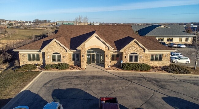
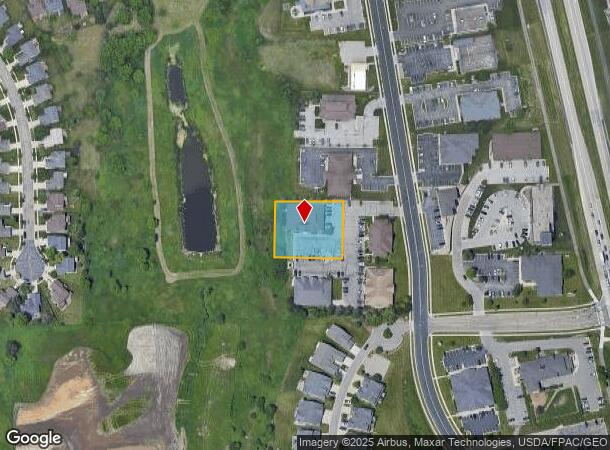
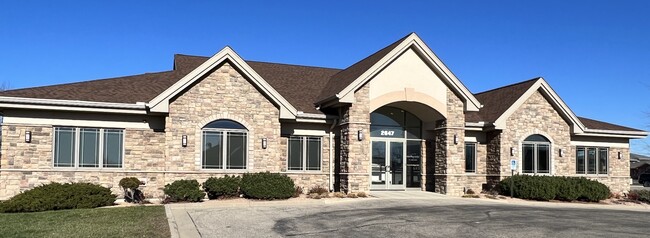
Property Record
2647 Superior Dr Nw, Rochester, MN 55901

NEARBY LISTINGS FOR SALE OR LEASE
Property Detail
2647 Superior Dr Nw
Rochester, MN
Circle Drive Business Ctr 4Th
74.20.43.068328
SECT-20 TWP-107 RANGE-014 CIRCLE DRIVE BUSINESS CTR 4TH LOT-001 BLOCK-001 LOT 1 BLK 1
Medicalclinic
Olmsted
D
Minnesota
27109C0142F
1
2025
0.70 AC
2024
Rochester
001403
Other Market Areas
7,092 SF
DEMOGRAPHICS near 2647 Superior Dr Nw
1 Mile
3 Mile
5 Mile
2024 Total Population
3,236
57,752
103,896
2029 Population
3,379
58,875
106,524
Pop Growth 2024-2029
+ 4.42%
+ 1.94%
+ 2.53%
Average Age
38
38
40
2024 Total Households
1,341
23,241
43,290
HH Growth 2024-2029
+ 4.40%
+ 1.82%
+ 2.58%
Median Household Inc
$90,089
$85,522
$80,706
Avg Household Size
2.40
2.40
2.30
2024 Avg HH Vehicles
2.00
2.00
2.00
Median Home Value
$313,144
$273,779
$278,896
Median Year Built
2003
1990
1985
Nearby Places
Map Layers
Map Styles
 Street
 Aerial
- Restaurants
- Banks
- Shops
- Fitness
- Groceries
PUBLIC TRANSPORTATION
AIRPORT
Rochester International
DRIVE
WALK
Distance
Rochester International
18 min
12.3 mi
SALE & LEASE HISTORY
LISTING DATE
SALE/LEASE

Sep 06, 2024
For Sale
Nov 17, 2023
For Lease
May 16, 2024
For Lease
Mar 29, 2023
For Sale
Mar 14, 2024
For Sale
Jan 25, 2023
For Lease
Nearby Properties
Address
Land Use
TOTAL SIZE
Lot Size
Zoning
Address
Land Use
TOTAL SIZE
Lot Size
Zoning
1,232,028 SF
2.03 AC
Address
Land Use
TOTAL SIZE
Lot Size
Zoning
2.77 AC
Address
Land Use
TOTAL SIZE
Lot Size
Zoning
271,310 SF
27.90 AC
Address
Land Use
TOTAL SIZE
Lot Size
Zoning
4,612 SF
21.16 AC
Address
Land Use
TOTAL SIZE
Lot Size
Zoning
960 SF
38.12 AC
Address
Land Use
TOTAL SIZE
Lot Size
Zoning
13,946 SF
34.10 AC
Address
Land Use
TOTAL SIZE
Lot Size
Zoning
236,769 SF
33.30 AC
Address
Land Use
TOTAL SIZE
Lot Size
Zoning
12,016 SF
20.31 AC
Address
Land Use
TOTAL SIZE
Lot Size
Zoning
2,420 SF
10.37 AC
Address
Land Use
TOTAL SIZE
Lot Size
Zoning
195,039 SF
8.25 AC
Address
Land Use
TOTAL SIZE
Lot Size
Zoning
53.73 AC
Address
Land Use
TOTAL SIZE
Lot Size
Zoning
167.09 AC
Address
Land Use
TOTAL SIZE
Lot Size
Zoning
4.63 AC
Address
Land Use
TOTAL SIZE
Lot Size
Zoning
250,864 SF
4.43 AC
Address
Land Use
TOTAL SIZE
Lot Size
Zoning
170,843 SF
13.66 AC
Address
Land Use
TOTAL SIZE
Lot Size
Zoning
2,300 SF
6.38 AC
Address
Land Use
TOTAL SIZE
Lot Size
Zoning
3,024 SF
4.93 AC
Address
Land Use
TOTAL SIZE
Lot Size
Zoning
3,915 SF
12.56 AC
Address
Land Use
TOTAL SIZE
Lot Size
Zoning
Address
Land Use
TOTAL SIZE
Lot Size
Zoning
117,897 SF
34.12 AC
Address
Land Use
TOTAL SIZE
Lot Size
Zoning
105,499 SF
0.85 AC
Address
Land Use
TOTAL SIZE
Lot Size
Zoning
72,675 SF
11.25 AC
Address
Land Use
TOTAL SIZE
Lot Size
Zoning
132,566 SF
2.85 AC
Address
Land Use
TOTAL SIZE
Lot Size
Zoning
77,176 SF
11.05 AC
Address
Land Use
TOTAL SIZE
Lot Size
Zoning
66,713 SF
8.79 AC
Address
Land Use
TOTAL SIZE
Lot Size
Zoning
528 SF
15.22 AC
Address
Land Use
TOTAL SIZE
Lot Size
Zoning
341 SF
5.46 AC
Address
Land Use
TOTAL SIZE
Lot Size
Zoning
4,994 SF
7.92 AC
Address
Land Use
TOTAL SIZE
Lot Size
Zoning
16,792 SF
7.07 AC
Address
Land Use
TOTAL SIZE
Lot Size
Zoning
44,352 SF
10.93 AC
The World's #1 Commercial Real Estate Marketplace
Connect with us
© 2025 CoStar Group
The information above has been obtained from sources believed reliable. While we do not doubt its accuracy we have not verified it and make no guarantee, warranty or representation about it. It is your responsibility to independently confirm its accuracy and completeness. Any projections, opinions, assumptions, or estimates used are for example only and do not represent the current or future performance of the property. The value of this transaction to you depends on tax and other factors which should be evaluated by your tax, financial, and legal advisors. You and your advisors should conduct a careful, independent investigation of the property to determine to your satisfaction the suitability of the property for your needs.