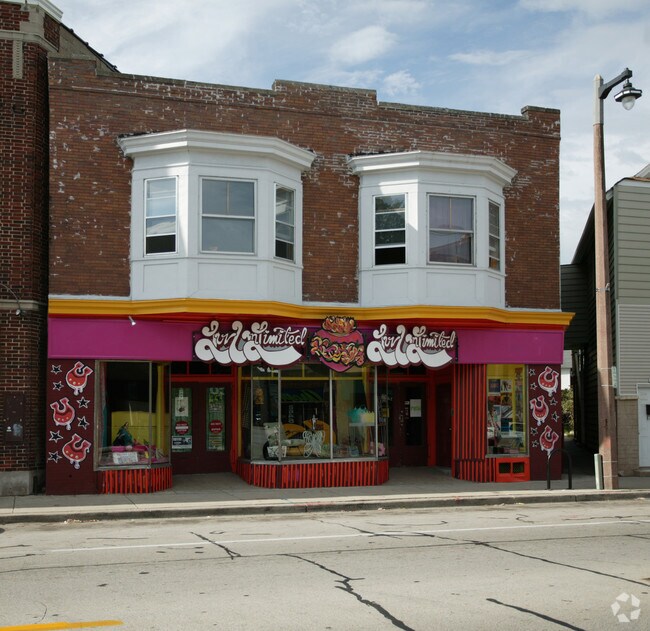
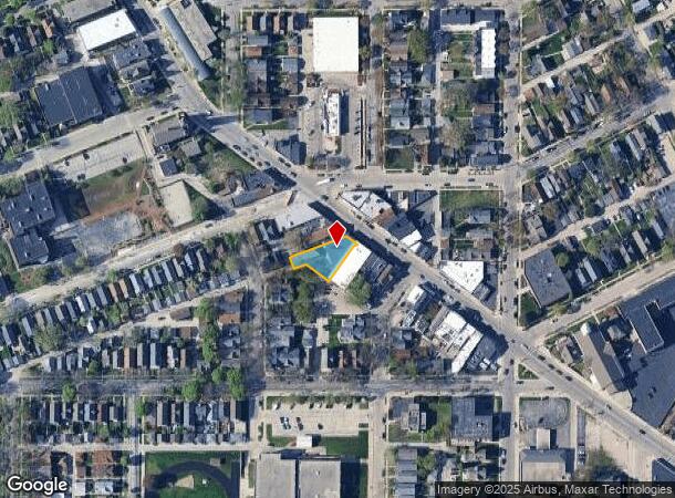
Property Record
2649 S Kinnickinnic Ave, Milwaukee, WI 53207
NEARBY LISTINGS FOR SALE OR LEASE
Property Detail
2649 S Kinnickinnic Ave
Milwaukee-Waukesha-West Allis, WI
Achenbachs Subd
500-0001-000-3
ACHENBACHS SUB PART NW4 & NE4 & PARTLY E2 NW4 & PARTLY W2 NE4 SEC09 TWP06N RNG22E
Retailwithmorethanonenonretailuse
Milwaukee
X
Wisconsin
55079C0157E
1
2024
0.21 AC
2024
Milwaukee SE
017900
Milwaukee/Madison
8,937 SF
DEMOGRAPHICS near 2649 S Kinnickinnic Ave
1 Mile
3 Mile
5 Mile
2024 Total Population
15,444
133,850
319,201
2029 Population
15,134
130,728
312,350
Pop Growth 2024-2029
(2.01%)
(2.33%)
(2.15%)
Average Age
38
36
36
2024 Total Households
7,662
52,778
137,687
HH Growth 2024-2029
(2.11%)
(2.29%)
(2.07%)
Median Household Inc
$73,781
$52,690
$51,104
Avg Household Size
2.00
2.40
2.20
2024 Avg HH Vehicles
1.00
2.00
1.00
Median Home Value
$237,358
$170,145
$180,163
Median Year Built
1946
1947
1950
Nearby Places
Map Layers
Map Styles
 Street
 Aerial
- Restaurants
- Banks
- Shops
- Fitness
- Groceries
PUBLIC TRANSPORTATION
AIRPORT
General Mitchell International
DRIVE
WALK
Distance
General Mitchell International
11 min
4.0 mi
Nearby Properties
Address
Land Use
TOTAL SIZE
Lot Size
Zoning
Address
Land Use
TOTAL SIZE
Lot Size
Zoning
1,140,196 SF
5.33 AC
C9F(A)
Address
Land Use
TOTAL SIZE
Lot Size
Zoning
1,330,372 SF
2.48 AC
C9F(A)
Address
Land Use
TOTAL SIZE
Lot Size
Zoning
41.05 AC
IO2
Address
Land Use
TOTAL SIZE
Lot Size
Zoning
715,000 SF
2.71 AC
C9F(B)
Address
Land Use
TOTAL SIZE
Lot Size
Zoning
523,726 SF
0.79 AC
C9B(B)
Address
Land Use
TOTAL SIZE
Lot Size
Zoning
607,577 SF
1.67 AC
PD
Address
Land Use
TOTAL SIZE
Lot Size
Zoning
370,160 SF
2.93 AC
C9F(A)
Address
Land Use
TOTAL SIZE
Lot Size
Zoning
362,007 SF
1.02 AC
C9F(A)
Address
Land Use
TOTAL SIZE
Lot Size
Zoning
414,410 SF
2.16 AC
C9F(A)
Address
Land Use
TOTAL SIZE
Lot Size
Zoning
173,610 SF
1.70 AC
IM
Address
Land Use
TOTAL SIZE
Lot Size
Zoning
319,559 SF
6.29 AC
PD
Address
Land Use
TOTAL SIZE
Lot Size
Zoning
425,000 SF
1.42 AC
C9F(A)
Address
Land Use
TOTAL SIZE
Lot Size
Zoning
179 AC
IH
Address
Land Use
TOTAL SIZE
Lot Size
Zoning
391,430 SF
0.99 AC
C9F(B)
Address
Land Use
TOTAL SIZE
Lot Size
Zoning
11.09 AC
Address
Land Use
TOTAL SIZE
Lot Size
Zoning
204,809 SF
1.04 AC
IM
Address
Land Use
TOTAL SIZE
Lot Size
Zoning
245,485 SF
6.30 AC
IM
Address
Land Use
TOTAL SIZE
Lot Size
Zoning
0.86 AC
C9F(A)
Address
Land Use
TOTAL SIZE
Lot Size
Zoning
166,554 SF
0.66 AC
C9F(A)
Address
Land Use
TOTAL SIZE
Lot Size
Zoning
1,709,128 SF
9.32 AC
PD
Address
Land Use
TOTAL SIZE
Lot Size
Zoning
12.02 AC
IO2
Address
Land Use
TOTAL SIZE
Lot Size
Zoning
147,010 SF
0.76 AC
C9F(A)
Address
Land Use
TOTAL SIZE
Lot Size
Zoning
322,007 SF
1.25 AC
C9F(A)
Address
Land Use
TOTAL SIZE
Lot Size
Zoning
236,218 SF
1.47 AC
C9F(A)
Address
Land Use
TOTAL SIZE
Lot Size
Zoning
15.43 AC
PD
Address
Land Use
TOTAL SIZE
Lot Size
Zoning
48.34 AC
IO1
Address
Land Use
TOTAL SIZE
Lot Size
Zoning
122,695 SF
0.39 AC
C9G
Address
Land Use
TOTAL SIZE
Lot Size
Zoning
2.85 AC
C9G
Address
Land Use
TOTAL SIZE
Lot Size
Zoning
110,000 SF
7.59 AC
TL
Address
Land Use
TOTAL SIZE
Lot Size
Zoning
2,610 SF
1.04 AC
IM
The World's #1 Commercial Real Estate Marketplace
Connect with us
© 2025 CoStar Group
The information above has been obtained from sources believed reliable. While we do not doubt its accuracy we have not verified it and make no guarantee, warranty or representation about it. It is your responsibility to independently confirm its accuracy and completeness. Any projections, opinions, assumptions, or estimates used are for example only and do not represent the current or future performance of the property. The value of this transaction to you depends on tax and other factors which should be evaluated by your tax, financial, and legal advisors. You and your advisors should conduct a careful, independent investigation of the property to determine to your satisfaction the suitability of the property for your needs.