Property Record
26491 Pine Ave, Rimforest, CA 92378


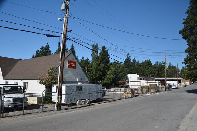

Property Detail
26491 Pine Ave
0336-055-10
RIM OF THE WORLD SUB NO 2 TR 2414 LOTS 50 THRU 54 INCL (NOTICE OF MERGER 9-7-89 #89-330790)
Storebuilding
San Bernardino
LACS
California
D Areas with possible but undetermined flood hazards.
50
2025
0.64 AC
2025
San Bernardino
011002
Inland Empire (California)
6,769 SF
Riverside-San Bernardino-Ontario, CA
NEARBY LISTINGS FOR SALE OR LEASE
DEMOGRAPHICS near 26491 Pine Ave
1 mile
3 mile
5 mile
2025 Total Population
1,576
10,071
21,456
2030 Population
1,484
9,619
20,601
Pop Growth 2025-2030
(5.84%)
(4.49%)
(3.98%)
Average Age
42
44
44
2025 Total Households
639
4,102
8,585
HH Growth 2025-2030
(5.95%)
(4.58%)
(4.25%)
Median Household Inc
$82,961
$95,897
$94,012
Avg Household Size
2.50
2.30
2.40
2025 Avg HH Vehicles
2.00
2.00
2.00
Median Home Value
$488,999
$594,980
$566,425
Median Year Built
1969
1973
1971
Nearby Places
Map Layers
Map Styles
 Street
 Aerial
Layers
 Traffic
 Biking
Places
Listings with unknown addresses are not visible on the map
- Restaurants
- Banks
- Shops
- Fitness
- Groceries
PUBLIC TRANSPORTATION
AIRPORT
Ontario International
Drive
Walk
Distance
Ontario International
54 min
38.7 mi
Freight Ports
Port of Long Beach
Drive
Walk
Distance
Port of Long Beach
111 min
86.7 mi
SALE & LEASE HISTORY
LISTING DATE
SALE/LEASE

Jul 29, 2020
For Sale
Nearby Properties
Address
Land Use
TOTAL SIZE
Lot Size
Zoning
Address
Land Use
TOTAL SIZE
Lot Size
Zoning
185,773 SF
15.42 AC
LACG
Address
Land Use
TOTAL SIZE
Lot Size
Zoning
73,307 SF
32.90 AC
CFSDRES
Address
Land Use
TOTAL SIZE
Lot Size
Zoning
160,928 SF
8.77 AC
LACG
Address
Land Use
TOTAL SIZE
Lot Size
Zoning
25.95 AC
CFSDRES
Address
Land Use
TOTAL SIZE
Lot Size
Zoning
79,205 SF
17.72 AC
Address
Land Use
TOTAL SIZE
Lot Size
Zoning
78,044 SF
3.18 AC
LACS
Address
Land Use
TOTAL SIZE
Lot Size
Zoning
32,675 SF
91.96 AC
LARC
Address
Land Use
TOTAL SIZE
Lot Size
Zoning
34,726 SF
1.02 AC
LACG
Address
Land Use
TOTAL SIZE
Lot Size
Zoning
13,816 SF
28.10 AC
Address
Land Use
TOTAL SIZE
Lot Size
Zoning
32,648 SF
1.44 AC
LACGSCP
Address
Land Use
TOTAL SIZE
Lot Size
Zoning
172.99 AC
Address
Land Use
TOTAL SIZE
Lot Size
Zoning
24,570 SF
2.24 AC
LACG
Address
Land Use
TOTAL SIZE
Lot Size
Zoning
46,398 SF
1.88 AC
CFCGSCP
Address
Land Use
TOTAL SIZE
Lot Size
Zoning
11,772 SF
0.22 AC
LACG
Address
Land Use
TOTAL SIZE
Lot Size
Zoning
Address
Land Use
TOTAL SIZE
Lot Size
Zoning
143.31 AC
Address
Land Use
TOTAL SIZE
Lot Size
Zoning
22,887 SF
19.30 AC
LARS14M
Address
Land Use
TOTAL SIZE
Lot Size
Zoning
22,542 SF
7.03 AC
LARS14M
Address
Land Use
TOTAL SIZE
Lot Size
Zoning
20,868 SF
68.79 AC
LASDRES
Address
Land Use
TOTAL SIZE
Lot Size
Zoning
25,759 SF
0.98 AC
LACGSCP
Address
Land Use
TOTAL SIZE
Lot Size
Zoning
3,570 SF
0.86 AC
LACS
Address
Land Use
TOTAL SIZE
Lot Size
Zoning
31,164 SF
0.82 AC
LACGSCP
Address
Land Use
TOTAL SIZE
Lot Size
Zoning
15,462 SF
0.52 AC
LACGSCP
Address
Land Use
TOTAL SIZE
Lot Size
Zoning
Address
Land Use
TOTAL SIZE
Lot Size
Zoning
61,908 SF
0.19 AC
LACG
Address
Land Use
TOTAL SIZE
Lot Size
Zoning
2,650 SF
1.33 AC
LACG
Address
Land Use
TOTAL SIZE
Lot Size
Zoning
3.45 AC
LACGSCP
Address
Land Use
TOTAL SIZE
Lot Size
Zoning
2,784 SF
0.70 AC
LACN
Address
Land Use
TOTAL SIZE
Lot Size
Zoning
8,501 SF
2.09 AC
LARM
Address
Land Use
TOTAL SIZE
Lot Size
Zoning
4,094 SF
0.18 AC
C1
The World's #1 Commercial Real Estate Marketplace
Connect with us
© 2026 CoStar Group
The information above has been obtained from sources believed reliable. While we do not doubt its accuracy we have not verified it and make no guarantee, warranty or representation about it. It is your responsibility to independently confirm its accuracy and completeness. Any projections, opinions, assumptions, or estimates used are for example only and do not represent the current or future performance of the property. The value of this transaction to you depends on tax and other factors which should be evaluated by your tax, financial, and legal advisors. You and your advisors should conduct a careful, independent investigation of the property to determine to your satisfaction the suitability of the property for your needs.