Property Record
265 Sw 11Th St, Redmond, OR 97756
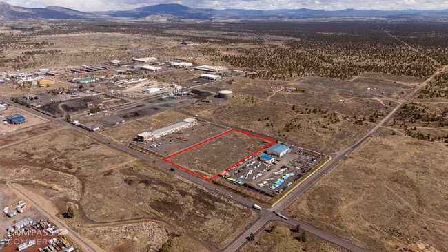


This Property Is For Sale
Property Detail
265 Sw 11Th St
Bend, OR
VISTA LA MONTE INDUSTRIAL PARK LOT 2
246631
DESCHUTES
Industrialacreage
Oregon
M2
2
B and X Area of moderate flood hazard, usually the area between the limits of the 100-year and 500-year floods.
4.60 AC
2025
Deschutes County
2025
Portland
000800
NEARBY LISTINGS FOR SALE OR LEASE
DEMOGRAPHICS near 265 Sw 11Th St
1 mile
3 mile
5 mile
2025 Total Population
2,235
29,458
38,387
2030 Population
2,279
30,186
39,321
Pop Growth 2025-2030
+ 1.97%
+ 2.47%
+ 2.43%
Average Age
39
39
40
2025 Total Households
879
11,103
14,589
HH Growth 2025-2030
+ 1.93%
+ 2.43%
+ 2.41%
Median Household Inc
$80,136
$87,923
$90,327
Avg Household Size
2.50
2.60
2.60
2025 Avg HH Vehicles
2.00
2.00
2.00
Median Home Value
$418,320
$476,826
$529,088
Median Year Built
1979
2000
1999
Nearby Places
Map Layers
Map Styles
 Street
 Aerial
Transit
 Traffic
 Biking
Places
Listings with unknown addresses are not visible on the map
- Restaurants
- Banks
- Shops
- Fitness
- Groceries
PUBLIC TRANSPORTATION
AIRPORT
Roberts Field
Drive
Walk
Distance
Roberts Field
8 min
3.0 mi
Nearby Properties
Address
Land Use
TOTAL SIZE
Lot Size
Zoning
Address
Land Use
TOTAL SIZE
Lot Size
Zoning
22.43 AC
M1
Address
Land Use
TOTAL SIZE
Lot Size
Zoning
1 SF
22.43 AC
M1
Address
Land Use
TOTAL SIZE
Lot Size
Zoning
207,480 SF
28.78 AC
PF
Address
Land Use
TOTAL SIZE
Lot Size
Zoning
4,045 SF
10.95 AC
R5
Address
Land Use
TOTAL SIZE
Lot Size
Zoning
682.50 AC
AIRPORT
Address
Land Use
TOTAL SIZE
Lot Size
Zoning
106,239 SF
13.84 AC
PF
Address
Land Use
TOTAL SIZE
Lot Size
Zoning
106,239 SF
13.84 AC
PF
Address
Land Use
TOTAL SIZE
Lot Size
Zoning
217,211 SF
23.83 AC
C1
Address
Land Use
TOTAL SIZE
Lot Size
Zoning
80,000 SF
18.93 AC
PF
Address
Land Use
TOTAL SIZE
Lot Size
Zoning
165,971 SF
11.96 AC
C2
Address
Land Use
TOTAL SIZE
Lot Size
Zoning
1,584 SF
3.44 AC
R5
Address
Land Use
TOTAL SIZE
Lot Size
Zoning
102,711 SF
11.23 AC
M2
Address
Land Use
TOTAL SIZE
Lot Size
Zoning
85,512 SF
4.10 AC
R4
Address
Land Use
TOTAL SIZE
Lot Size
Zoning
37,618 SF
24.38 AC
PF-L
Address
Land Use
TOTAL SIZE
Lot Size
Zoning
50,425 SF
5.62 AC
PF
Address
Land Use
TOTAL SIZE
Lot Size
Zoning
297.40 AC
AIRPORT
Address
Land Use
TOTAL SIZE
Lot Size
Zoning
297.40 AC
AIRPORT
Address
Land Use
TOTAL SIZE
Lot Size
Zoning
35,943 SF
13.78 AC
Address
Land Use
TOTAL SIZE
Lot Size
Zoning
8,724 SF
13.78 AC
Address
Land Use
TOTAL SIZE
Lot Size
Zoning
109,112 SF
13.78 AC
C1
Address
Land Use
TOTAL SIZE
Lot Size
Zoning
14,423 SF
13.78 AC
C1
Address
Land Use
TOTAL SIZE
Lot Size
Zoning
16.01 AC
M1
Address
Land Use
TOTAL SIZE
Lot Size
Zoning
30,000 SF
16.01 AC
M1
Address
Land Use
TOTAL SIZE
Lot Size
Zoning
16.01 AC
M1
Address
Land Use
TOTAL SIZE
Lot Size
Zoning
5,005 SF
562.44 AC
AIRPORT
Address
Land Use
TOTAL SIZE
Lot Size
Zoning
2 SF
562.44 AC
AIRPORT
Address
Land Use
TOTAL SIZE
Lot Size
Zoning
1,900 SF
562.44 AC
Address
Land Use
TOTAL SIZE
Lot Size
Zoning
3,038 SF
562.44 AC
AIRPORT
Address
Land Use
TOTAL SIZE
Lot Size
Zoning
15,750 SF
562.44 AC
AIRPORT
Address
Land Use
TOTAL SIZE
Lot Size
Zoning
7,138 SF
562.44 AC
AIRPORT
The World's #1 Commercial Real Estate Marketplace
Connect with us
© 2026 CoStar Group
The information above has been obtained from sources believed reliable. While we do not doubt its accuracy we have not verified it and make no guarantee, warranty or representation about it. It is your responsibility to independently confirm its accuracy and completeness. Any projections, opinions, assumptions, or estimates used are for example only and do not represent the current or future performance of the property. The value of this transaction to you depends on tax and other factors which should be evaluated by your tax, financial, and legal advisors. You and your advisors should conduct a careful, independent investigation of the property to determine to your satisfaction the suitability of the property for your needs.