Property Record
265 Brian Ave, Silverthorne, CO 80498
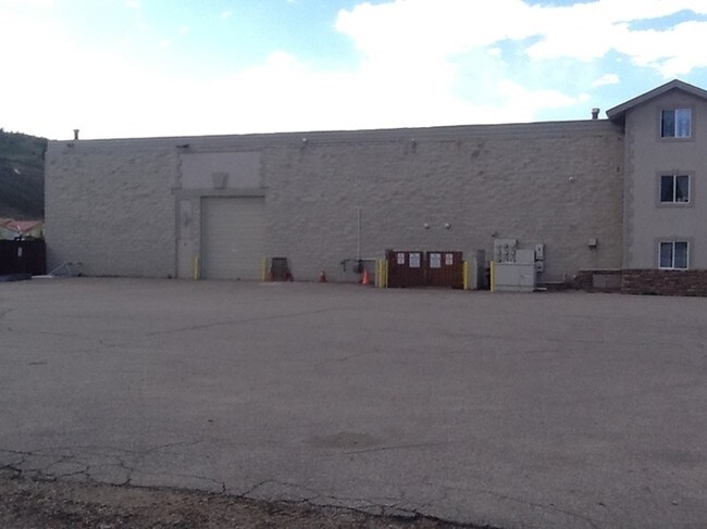

Property Detail
265 Brian Ave
1500102
LOT 8 BLOCK 1 ENTERPRISE PARK SUB
Residentialacreage
Summit
SC-2
Colorado
B and X Area of moderate flood hazard, usually the area between the limits of the 100-year and 500-year floods.
8
2023
0.86 AC
2024
Colorado Ski Area
000102
Other Market Areas
20,029 SF
Breckenridge, CO
NEARBY LISTINGS FOR SALE OR LEASE
-
-
View all Silverthorne listings for lease on LoopNet.com
DEMOGRAPHICS near 265 Brian Ave
1 mile
3 mile
5 mile
2025 Total Population
2,242
10,641
18,552
2030 Population
2,211
10,553
18,441
Pop Growth 2025-2030
(1.38%)
(0.83%)
(0.60%)
Average Age
39
40
40
2025 Total Households
940
4,365
7,530
HH Growth 2025-2030
(0.96%)
(0.37%)
(0.57%)
Median Household Inc
$108,854
$101,758
$113,706
Avg Household Size
2.40
2.40
2.40
2025 Avg HH Vehicles
2.00
2.00
2.00
Median Home Value
$770,504
$895,114
$910,256
Median Year Built
1987
1989
1991
Nearby Places
Map Layers
Map Styles
 Street
 Aerial
Transit
 Traffic
 Biking
Places
Listings with unknown addresses are not visible on the map
- Restaurants
- Banks
- Shops
- Fitness
- Groceries
SALE & LEASE HISTORY
LISTING DATE
SALE/LEASE

Aug 30, 2018
For Lease
Nearby Properties
Address
Land Use
TOTAL SIZE
Lot Size
Zoning
Address
Land Use
TOTAL SIZE
Lot Size
Zoning
98,684 SF
5.88 AC
DPUD
Address
Land Use
TOTAL SIZE
Lot Size
Zoning
125,344 SF
1.50 AC
C
Address
Land Use
TOTAL SIZE
Lot Size
Zoning
69,543 SF
0.55 AC
STC
Address
Land Use
TOTAL SIZE
Lot Size
Zoning
58,527 SF
2.58 AC
C-1
Address
Land Use
TOTAL SIZE
Lot Size
Zoning
34,922 SF
1.53 AC
SC-1
Address
Land Use
TOTAL SIZE
Lot Size
Zoning
127,470 SF
4.43 AC
FGW
Address
Land Use
TOTAL SIZE
Lot Size
Zoning
97,772 SF
4.48 AC
C-1
Address
Land Use
TOTAL SIZE
Lot Size
Zoning
111,644 SF
11.08 AC
C-1
Address
Land Use
TOTAL SIZE
Lot Size
Zoning
83,981 SF
2.99 AC
FGW
Address
Land Use
TOTAL SIZE
Lot Size
Zoning
76,047 SF
3.81 AC
SC-2
Address
Land Use
TOTAL SIZE
Lot Size
Zoning
121,451 SF
11.02 AC
C-1
Address
Land Use
TOTAL SIZE
Lot Size
Zoning
47,857 SF
3.26 AC
C-1
Address
Land Use
TOTAL SIZE
Lot Size
Zoning
55,439 SF
5.60 AC
PUD
Address
Land Use
TOTAL SIZE
Lot Size
Zoning
55,073 SF
3.71 AC
MU
Address
Land Use
TOTAL SIZE
Lot Size
Zoning
29,116 SF
3.47 AC
C-1
Address
Land Use
TOTAL SIZE
Lot Size
Zoning
43,660 SF
3.58 AC
C-1
Address
Land Use
TOTAL SIZE
Lot Size
Zoning
22,565 SF
3.71 AC
PUD
Address
Land Use
TOTAL SIZE
Lot Size
Zoning
61,613 SF
6.34 AC
MU
Address
Land Use
TOTAL SIZE
Lot Size
Zoning
40,585 SF
5.43 AC
PUD
Address
Land Use
TOTAL SIZE
Lot Size
Zoning
35,442 SF
3.67 AC
C-1
Address
Land Use
TOTAL SIZE
Lot Size
Zoning
28,280 SF
5.61 AC
C-1
Address
Land Use
TOTAL SIZE
Lot Size
Zoning
29,521 SF
0.58 AC
STC
Address
Land Use
TOTAL SIZE
Lot Size
Zoning
23,230 SF
2.12 AC
RF
Address
Land Use
TOTAL SIZE
Lot Size
Zoning
25,245 SF
6.11 AC
C-1
Address
Land Use
TOTAL SIZE
Lot Size
Zoning
4,900 SF
1.23 AC
C-1
Address
Land Use
TOTAL SIZE
Lot Size
Zoning
24,996 SF
2.03 AC
RF
Address
Land Use
TOTAL SIZE
Lot Size
Zoning
13,773 SF
1.96 AC
R-6
Address
Land Use
TOTAL SIZE
Lot Size
Zoning
11,149 SF
1.76 AC
RH
Address
Land Use
TOTAL SIZE
Lot Size
Zoning
31,768 SF
1.49 AC
C-1
Address
Land Use
TOTAL SIZE
Lot Size
Zoning
15,441 SF
1.07 AC
PUD
The World's #1 Commercial Real Estate Marketplace
Connect with us
© 2026 CoStar Group
The information above has been obtained from sources believed reliable. While we do not doubt its accuracy we have not verified it and make no guarantee, warranty or representation about it. It is your responsibility to independently confirm its accuracy and completeness. Any projections, opinions, assumptions, or estimates used are for example only and do not represent the current or future performance of the property. The value of this transaction to you depends on tax and other factors which should be evaluated by your tax, financial, and legal advisors. You and your advisors should conduct a careful, independent investigation of the property to determine to your satisfaction the suitability of the property for your needs.