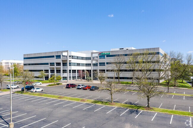
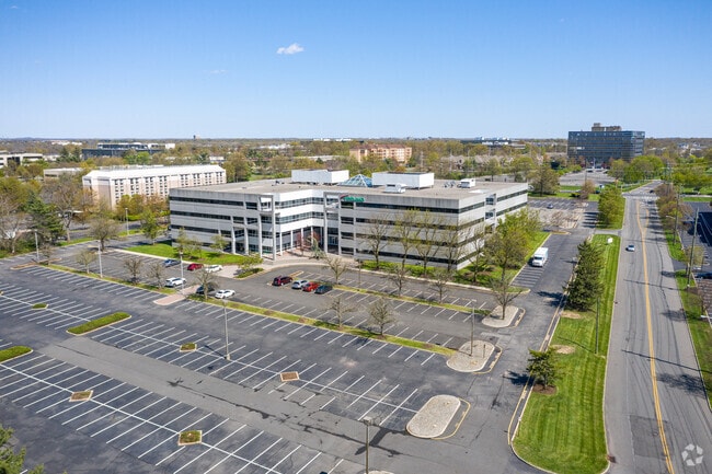
Property Record
265 Davidson Ave, Somerset, NJ 08873


NEARBY LISTINGS FOR SALE OR LEASE
Property Detail
265 Davidson Ave
08-00502-02-00043-02
Somerset
Officebuilding
New Jersey
A
43.2
34023C0017F
14.26 AC
2024
Route 287 West
2025
Northern New Jersey
053501
Newark, NJ-PA
3,416 SF
DEMOGRAPHICS near 265 Davidson Ave
1 Mile
3 Mile
5 Mile
2024 Total Population
3,793
65,024
188,250
2029 Population
3,829
64,828
187,710
Pop Growth 2024-2029
+ 0.95%
(0.30%)
(0.29%)
Average Age
49
43
40
2024 Total Households
1,621
24,967
64,796
HH Growth 2024-2029
+ 0.86%
(0.27%)
(0.25%)
Median Household Inc
$121,506
$103,219
$100,816
Avg Household Size
2.30
2.50
2.70
2024 Avg HH Vehicles
2.00
2.00
2.00
Median Home Value
$446,441
$378,343
$378,261
Median Year Built
2003
1979
1971
Nearby Places
Map Layers
Map Styles
 Street
 Aerial
- Restaurants
- Banks
- Shops
- Fitness
- Groceries
PUBLIC TRANSPORTATION
COMMUTER RAIL
Bound Brook (Raritan Valley Line - NJ Transit Commuter Rail (NJ Transit))
DRIVE
WALK
Distance
Bound Brook (Raritan Valley Line - NJ Transit Commuter Rail (NJ Transit))
6 min
2.6 mi
Bridgewater (Raritan Valley Line - NJ Transit Commuter Rail (NJ Transit))
DRIVE
WALK
Distance
Bridgewater (Raritan Valley Line - NJ Transit Commuter Rail (NJ Transit))
9 min
3.8 mi
AIRPORT
Trenton Mercer
DRIVE
WALK
Distance
Trenton Mercer
53 min
32.8 mi
Newark Liberty International
DRIVE
WALK
Distance
Newark Liberty International
42 min
32.8 mi
Freight Ports
New York Container Terminal
DRIVE
WALK
Distance
New York Container Terminal
36 min
27.1 mi
SALE & LEASE HISTORY
LISTING DATE
SALE/LEASE

Sep 24, 2016
For Lease
Mar 06, 2020
For Lease
Jan 11, 2017
For Lease
Nearby Properties
Address
Land Use
TOTAL SIZE
Lot Size
Zoning
Address
Land Use
TOTAL SIZE
Lot Size
Zoning
31.49 AC
LI5
Address
Land Use
TOTAL SIZE
Lot Size
Zoning
6,625 SF
22.51 AC
B-I
Address
Land Use
TOTAL SIZE
Lot Size
Zoning
78.71 AC
ER
Address
Land Use
TOTAL SIZE
Lot Size
Zoning
70.22 AC
B-I
Address
Land Use
TOTAL SIZE
Lot Size
Zoning
48.30 AC
GB
Address
Land Use
TOTAL SIZE
Lot Size
Zoning
17.01 AC
B-I
Address
Land Use
TOTAL SIZE
Lot Size
Zoning
16,397 SF
41.98 AC
R20
Address
Land Use
TOTAL SIZE
Lot Size
Zoning
19.46 AC
B-I
Address
Land Use
TOTAL SIZE
Lot Size
Zoning
31.50 AC
B-I
Address
Land Use
TOTAL SIZE
Lot Size
Zoning
22.36 AC
PAC
Address
Land Use
TOTAL SIZE
Lot Size
Zoning
2,450 SF
26.84 AC
B-I
Address
Land Use
TOTAL SIZE
Lot Size
Zoning
26.23 AC
B-I
Address
Land Use
TOTAL SIZE
Lot Size
Zoning
32.92 AC
B-I
Address
Land Use
TOTAL SIZE
Lot Size
Zoning
Address
Land Use
TOTAL SIZE
Lot Size
Zoning
32,704 SF
44.53 AC
LI5
Address
Land Use
TOTAL SIZE
Lot Size
Zoning
24.34 AC
IND
Address
Land Use
TOTAL SIZE
Lot Size
Zoning
2,488 SF
16.46 AC
PAC
Address
Land Use
TOTAL SIZE
Lot Size
Zoning
26.53 AC
B-I
Address
Land Use
TOTAL SIZE
Lot Size
Zoning
4.05 AC
Address
Land Use
TOTAL SIZE
Lot Size
Zoning
13.38 AC
B2
Address
Land Use
TOTAL SIZE
Lot Size
Zoning
275,431 SF
17.91 AC
LI5
Address
Land Use
TOTAL SIZE
Lot Size
Zoning
7,475 SF
20.98 AC
B-I
Address
Land Use
TOTAL SIZE
Lot Size
Zoning
17.65 AC
B-I
Address
Land Use
TOTAL SIZE
Lot Size
Zoning
235,855 SF
14.48 AC
B-I
Address
Land Use
TOTAL SIZE
Lot Size
Zoning
19.90 AC
IND
Address
Land Use
TOTAL SIZE
Lot Size
Zoning
19.63 AC
B-I
Address
Land Use
TOTAL SIZE
Lot Size
Zoning
7,580 SF
22 AC
B-I
Address
Land Use
TOTAL SIZE
Lot Size
Zoning
34.20 AC
B-I
Address
Land Use
TOTAL SIZE
Lot Size
Zoning
34.43 AC
B-I
Address
Land Use
TOTAL SIZE
Lot Size
Zoning
The World's #1 Commercial Real Estate Marketplace
Connect with us
© 2026 CoStar Group
The information above has been obtained from sources believed reliable. While we do not doubt its accuracy we have not verified it and make no guarantee, warranty or representation about it. It is your responsibility to independently confirm its accuracy and completeness. Any projections, opinions, assumptions, or estimates used are for example only and do not represent the current or future performance of the property. The value of this transaction to you depends on tax and other factors which should be evaluated by your tax, financial, and legal advisors. You and your advisors should conduct a careful, independent investigation of the property to determine to your satisfaction the suitability of the property for your needs.