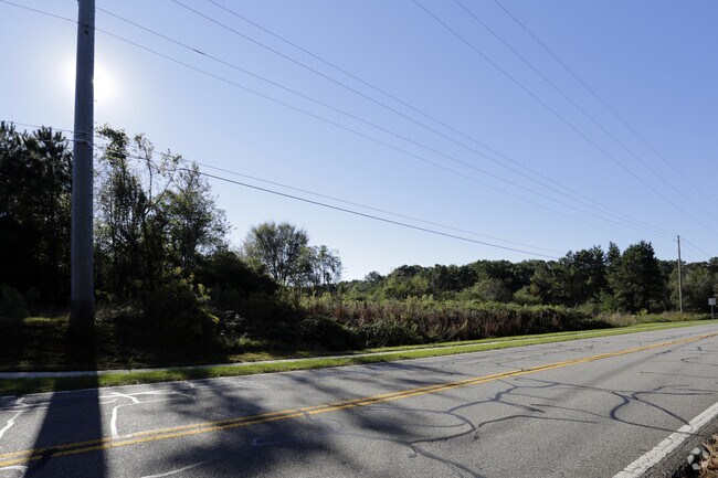
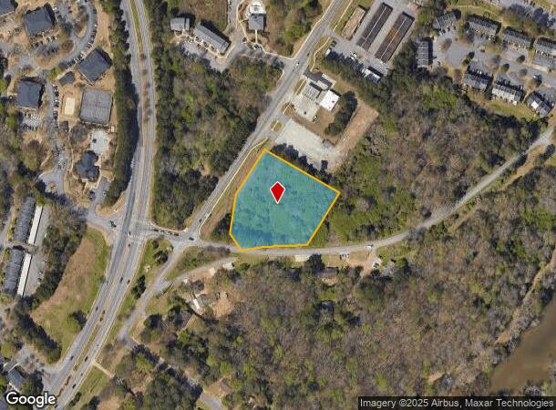
Property Record
265 Epps Bridge Ln, Athens, GA 30606
NEARBY LISTINGS FOR SALE OR LEASE
Property Detail
265 Epps Bridge Ln
Athens-Clarke County, GA
Com-St-058->00-03
123-012-B
SUBD BLK: C; DEEDED ACS: 2.378
Commercialacreage
Clarke
X
Georgia
13059C0024F
2.22 AC
2025
Epps Bridge
2025
Other Market Areas
001200
DEMOGRAPHICS near 265 Epps Bridge Ln
1 Mile
3 Mile
5 Mile
2024 Total Population
6,828
52,364
109,161
2029 Population
6,837
52,886
111,229
Pop Growth 2024-2029
+ 0.13%
+ 1.00%
+ 1.89%
Average Age
37
36
34
2024 Total Households
3,048
21,054
42,444
HH Growth 2024-2029
+ 0.13%
+ 0.93%
+ 1.72%
Median Household Inc
$57,368
$61,432
$54,016
Avg Household Size
2.10
2.20
2.30
2024 Avg HH Vehicles
2.00
2.00
2.00
Median Home Value
$325,696
$325,281
$293,670
Median Year Built
1993
1983
1988
Nearby Places
Map Layers
Map Styles
 Street
 Aerial
- Restaurants
- Banks
- Shops
- Fitness
- Groceries
SALE & LEASE HISTORY
LISTING DATE
SALE/LEASE

Oct 24, 2018
For Sale
Nearby Properties
Address
Land Use
TOTAL SIZE
Lot Size
Zoning
Address
Land Use
TOTAL SIZE
Lot Size
Zoning
11.36 AC
G
Address
Land Use
TOTAL SIZE
Lot Size
Zoning
163,904 SF
3.75 AC
C-D
Address
Land Use
TOTAL SIZE
Lot Size
Zoning
21.64 AC
G
Address
Land Use
TOTAL SIZE
Lot Size
Zoning
85,608 SF
63.75 AC
RM-2
Address
Land Use
TOTAL SIZE
Lot Size
Zoning
87,066 SF
36.66 AC
RM-2
Address
Land Use
TOTAL SIZE
Lot Size
Zoning
212,919 SF
37.92 AC
RM-1
Address
Land Use
TOTAL SIZE
Lot Size
Zoning
81,792 SF
30.99 AC
RM-1
Address
Land Use
TOTAL SIZE
Lot Size
Zoning
56.15 AC
G
Address
Land Use
TOTAL SIZE
Lot Size
Zoning
20 AC
G
Address
Land Use
TOTAL SIZE
Lot Size
Zoning
17.23 AC
G
Address
Land Use
TOTAL SIZE
Lot Size
Zoning
97,317 SF
24.31 AC
C-G
Address
Land Use
TOTAL SIZE
Lot Size
Zoning
4,907 SF
28.35 AC
RM-2
Address
Land Use
TOTAL SIZE
Lot Size
Zoning
17,388 SF
21.49 AC
RM-1
Address
Land Use
TOTAL SIZE
Lot Size
Zoning
18.47 AC
C-G
Address
Land Use
TOTAL SIZE
Lot Size
Zoning
98,402 SF
8.11 AC
B-2
Address
Land Use
TOTAL SIZE
Lot Size
Zoning
108,668 SF
37.79 AC
001
Address
Land Use
TOTAL SIZE
Lot Size
Zoning
66,200 SF
13.35 AC
G
Address
Land Use
TOTAL SIZE
Lot Size
Zoning
2,505 SF
25.03 AC
RM-1
Address
Land Use
TOTAL SIZE
Lot Size
Zoning
36.74 AC
G
Address
Land Use
TOTAL SIZE
Lot Size
Zoning
5.74 AC
G
Address
Land Use
TOTAL SIZE
Lot Size
Zoning
113,787 SF
32.92 AC
C-G
Address
Land Use
TOTAL SIZE
Lot Size
Zoning
1,511 SF
17.01 AC
RM-1
Address
Land Use
TOTAL SIZE
Lot Size
Zoning
5.91 AC
G
Address
Land Use
TOTAL SIZE
Lot Size
Zoning
101,920 SF
18.01 AC
RM-2
Address
Land Use
TOTAL SIZE
Lot Size
Zoning
Address
Land Use
TOTAL SIZE
Lot Size
Zoning
1,956 SF
93.87 AC
RM-1
Address
Land Use
TOTAL SIZE
Lot Size
Zoning
4,373 SF
25.41 AC
RM-2
Address
Land Use
TOTAL SIZE
Lot Size
Zoning
1,672 SF
23.70 AC
RM-2
Address
Land Use
TOTAL SIZE
Lot Size
Zoning
38,928 SF
18.56 AC
RM-2
Address
Land Use
TOTAL SIZE
Lot Size
Zoning
154,270 SF
23.19 AC
The World's #1 Commercial Real Estate Marketplace
Connect with us
© 2025 CoStar Group
The information above has been obtained from sources believed reliable. While we do not doubt its accuracy we have not verified it and make no guarantee, warranty or representation about it. It is your responsibility to independently confirm its accuracy and completeness. Any projections, opinions, assumptions, or estimates used are for example only and do not represent the current or future performance of the property. The value of this transaction to you depends on tax and other factors which should be evaluated by your tax, financial, and legal advisors. You and your advisors should conduct a careful, independent investigation of the property to determine to your satisfaction the suitability of the property for your needs.