Property Record
265 Howard St, Lapeer, MI 48446
This Property Is For Sale
NEARBY LISTINGS FOR SALE OR LEASE
Property Detail
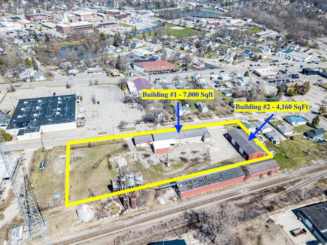
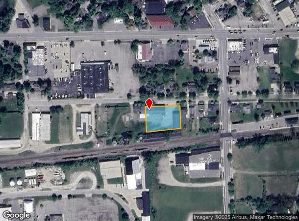
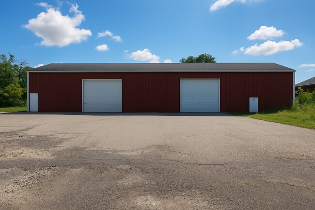
265 Howard St
L21-27-500-040-00
City Of Lapeer Jennings Add
Storebuilding
CITY OF LAPEER JENNINGS ADDITION BLK 3 EX E 220 FT & SLY 30 FT THEREOF (L=9 P=598 SEC 5, T7N-R9E)
X
Lapeer
26087C0266E
Michigan
2024
0.67 AC
2025
St Clair & Lapeer Counties
337500
Detroit
12,024 SF
Detroit-Warren-Dearborn, MI
DEMOGRAPHICS near 265 Howard St
1 Mile
3 Mile
5 Mile
2024 Total Population
5,725
15,836
23,511
2029 Population
5,760
15,958
23,635
Pop Growth 2024-2029
+ 0.61%
+ 0.77%
+ 0.53%
Average Age
40
42
43
2024 Total Households
2,521
6,797
9,798
HH Growth 2024-2029
+ 0.63%
+ 0.78%
+ 0.54%
Median Household Inc
$49,306
$54,839
$62,858
Avg Household Size
2.20
2.20
2.30
2024 Avg HH Vehicles
1.00
2.00
2.00
Median Home Value
$131,775
$155,382
$174,804
Median Year Built
1974
1976
1977
Nearby Places
- Restaurants
- Banks
- Shops
- Fitness
- Groceries
PUBLIC TRANSPORTATION
COMMUTER RAIL
Lapeer Amtrak Station (Blue Water - Amtrak)
DRIVE
WALK
Distance
Lapeer Amtrak Station (Blue Water - Amtrak)
0 min
3 min
0.2 mi
AIRPORT
Bishop International
DRIVE
WALK
Distance
Bishop International
43 min
29.4 mi
Freight Ports
Port of Toledo
DRIVE
WALK
Distance
Port of Toledo
151 min
117.8 mi
Nearby Properties
Address
Land Use
TOTAL SIZE
Lot Size
Zoning
Address
Land Use
TOTAL SIZE
Lot Size
Zoning
216,630 SF
33.87 AC
B3 REG
Address
Land Use
TOTAL SIZE
Lot Size
Zoning
184,894 SF
21.97 AC
RM-1 M
Address
Land Use
TOTAL SIZE
Lot Size
Zoning
108.23 AC
MHP
Address
Land Use
TOTAL SIZE
Lot Size
Zoning
206,957 SF
31.13 AC
B3 REG
Address
Land Use
TOTAL SIZE
Lot Size
Zoning
672 SF
40 AC
MHP
Address
Land Use
TOTAL SIZE
Lot Size
Zoning
85,600 SF
6.93 AC
RM-1 MULTP
Address
Land Use
TOTAL SIZE
Lot Size
Zoning
132,030 SF
9.35 AC
B2 GEN
Address
Land Use
TOTAL SIZE
Lot Size
Zoning
83,778 SF
7.17 AC
B2 GEN
Address
Land Use
TOTAL SIZE
Lot Size
Zoning
111,975 SF
20 AC
B3 REG
Address
Land Use
TOTAL SIZE
Lot Size
Zoning
8.63 AC
RM-1 M
Address
Land Use
TOTAL SIZE
Lot Size
Zoning
2,400 SF
88.23 AC
MPH
Address
Land Use
TOTAL SIZE
Lot Size
Zoning
240,748 SF
22.20 AC
I1 INDU
Address
Land Use
TOTAL SIZE
Lot Size
Zoning
142,610 SF
35.53 AC
M-2
Address
Land Use
TOTAL SIZE
Lot Size
Zoning
120,480 SF
7.53 AC
RM-1 M
Address
Land Use
TOTAL SIZE
Lot Size
Zoning
4.53 AC
RM-1 MULTP
Address
Land Use
TOTAL SIZE
Lot Size
Zoning
80,728 SF
20 AC
RM-1 M
Address
Land Use
TOTAL SIZE
Lot Size
Zoning
55,270 SF
4.80 AC
R2 1 FM
Address
Land Use
TOTAL SIZE
Lot Size
Zoning
94,442 SF
9 AC
B2 GEN
Address
Land Use
TOTAL SIZE
Lot Size
Zoning
10.32 AC
B2 GEN
Address
Land Use
TOTAL SIZE
Lot Size
Zoning
10.62 AC
I2 PLAN
Address
Land Use
TOTAL SIZE
Lot Size
Zoning
528 SF
21 AC
MHP
Address
Land Use
TOTAL SIZE
Lot Size
Zoning
2.86 AC
RM-1 M
Address
Land Use
TOTAL SIZE
Lot Size
Zoning
71,532 SF
4.42 AC
RM-1 M
Address
Land Use
TOTAL SIZE
Lot Size
Zoning
17,750 SF
2.34 AC
OS-1
Address
Land Use
TOTAL SIZE
Lot Size
Zoning
2.07 AC
R2 1 FM
Address
Land Use
TOTAL SIZE
Lot Size
Zoning
28,531 SF
17 AC
R-1A
Address
Land Use
TOTAL SIZE
Lot Size
Zoning
36,971 SF
10.12 AC
B2 GEN
Address
Land Use
TOTAL SIZE
Lot Size
Zoning
5.59 AC
RM-1 M
Address
Land Use
TOTAL SIZE
Lot Size
Zoning
11.57 AC
I2 PLAN
Address
Land Use
TOTAL SIZE
Lot Size
Zoning
26,638 SF
7.31 AC
OS1 OFF
The World's #1 Commercial Real Estate Marketplace
Connect with us
© 2025 CoStar Group
The information above has been obtained from sources believed reliable. While we do not doubt its accuracy we have not verified it and make no guarantee, warranty or representation about it. It is your responsibility to independently confirm its accuracy and completeness. Any projections, opinions, assumptions, or estimates used are for example only and do not represent the current or future performance of the property. The value of this transaction to you depends on tax and other factors which should be evaluated by your tax, financial, and legal advisors. You and your advisors should conduct a careful, independent investigation of the property to determine to your satisfaction the suitability of the property for your needs.