Property Record
265 Jonesboro Rd, Jonesboro, GA 30236

NEARBY LISTINGS FOR SALE OR LEASE
Property Detail
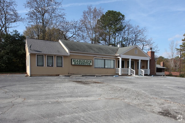
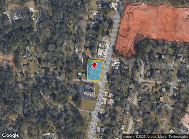
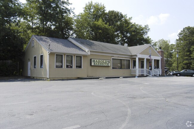
265 Jonesboro Rd
12-0048A-00D-001
Adamsons Duncan Heights
Restaurantbuilding
Clayton
X
Georgia
13063C0086F
48
2025
0.71 AC
2025
Riverdale/Jonesboro
040630
Atlanta
3,054 SF
Atlanta-Sandy Springs-Roswell, GA
DEMOGRAPHICS near 265 Jonesboro Rd
1 Mile
3 Mile
5 Mile
2024 Total Population
7,039
67,679
188,070
2029 Population
6,984
67,475
187,576
Pop Growth 2024-2029
(0.78%)
(0.30%)
(0.26%)
Average Age
35
36
36
2024 Total Households
2,836
24,496
66,905
HH Growth 2024-2029
(0.88%)
(0.30%)
(0.23%)
Median Household Inc
$47,350
$51,812
$52,908
Avg Household Size
2.40
2.70
2.70
2024 Avg HH Vehicles
2.00
2.00
2.00
Median Home Value
$149,319
$167,960
$172,804
Median Year Built
1984
1983
1985
Nearby Places
Map Layers
Map Styles
 Street
 Aerial
- Restaurants
- Banks
- Shops
- Fitness
- Groceries
PUBLIC TRANSPORTATION
AIRPORT
Hartsfield - Jackson Atlanta International
DRIVE
WALK
Distance
Hartsfield - Jackson Atlanta International
19 min
10.8 mi
Freight Ports
Georgia Ports - Savannah
DRIVE
WALK
Distance
Georgia Ports - Savannah
264 min
235.0 mi
SALE & LEASE HISTORY
LISTING DATE
SALE/LEASE

Sep 23, 2016
For Sale
Nearby Properties
Address
Land Use
TOTAL SIZE
Lot Size
Zoning
Address
Land Use
TOTAL SIZE
Lot Size
Zoning
231,046 SF
97.58 AC
C
Address
Land Use
TOTAL SIZE
Lot Size
Zoning
217,289 SF
52.12 AC
OI
Address
Land Use
TOTAL SIZE
Lot Size
Zoning
194,682 SF
27.80 AC
OI
Address
Land Use
TOTAL SIZE
Lot Size
Zoning
324 SF
49.49 AC
RM
Address
Land Use
TOTAL SIZE
Lot Size
Zoning
25.16 AC
RM
Address
Land Use
TOTAL SIZE
Lot Size
Zoning
330 SF
33.30 AC
RM
Address
Land Use
TOTAL SIZE
Lot Size
Zoning
11.31 AC
RM
Address
Land Use
TOTAL SIZE
Lot Size
Zoning
250 SF
31.25 AC
RM
Address
Land Use
TOTAL SIZE
Lot Size
Zoning
123,000 SF
48 AC
RS110
Address
Land Use
TOTAL SIZE
Lot Size
Zoning
1,140 SF
187.84 AC
MX
Address
Land Use
TOTAL SIZE
Lot Size
Zoning
200 SF
23.02 AC
RM
Address
Land Use
TOTAL SIZE
Lot Size
Zoning
707,780 SF
85.14 AC
MXI
Address
Land Use
TOTAL SIZE
Lot Size
Zoning
230 SF
27.09 AC
RM
Address
Land Use
TOTAL SIZE
Lot Size
Zoning
123,842 SF
31.53 AC
RS110
Address
Land Use
TOTAL SIZE
Lot Size
Zoning
200,370 SF
23.81 AC
C
Address
Land Use
TOTAL SIZE
Lot Size
Zoning
351,207 SF
20 AC
HI
Address
Land Use
TOTAL SIZE
Lot Size
Zoning
316 SF
34.30 AC
RG75
Address
Land Use
TOTAL SIZE
Lot Size
Zoning
216 SF
31.17 AC
RM
Address
Land Use
TOTAL SIZE
Lot Size
Zoning
500,415 SF
26.99 AC
HI
Address
Land Use
TOTAL SIZE
Lot Size
Zoning
224 SF
25 AC
C
Address
Land Use
TOTAL SIZE
Lot Size
Zoning
252 SF
27.14 AC
RM
Address
Land Use
TOTAL SIZE
Lot Size
Zoning
87,449 SF
14 AC
MC
Address
Land Use
TOTAL SIZE
Lot Size
Zoning
200 SF
20.23 AC
RM
Address
Land Use
TOTAL SIZE
Lot Size
Zoning
190 SF
21.66 AC
RM
Address
Land Use
TOTAL SIZE
Lot Size
Zoning
410 SF
35 AC
RM
Address
Land Use
TOTAL SIZE
Lot Size
Zoning
14,230 AC
C
Address
Land Use
TOTAL SIZE
Lot Size
Zoning
220 SF
26.84 AC
RM
Address
Land Use
TOTAL SIZE
Lot Size
Zoning
252 SF
23.62 AC
RM
Address
Land Use
TOTAL SIZE
Lot Size
Zoning
30.90 AC
RS110
Address
Land Use
TOTAL SIZE
Lot Size
Zoning
65,798 SF
7.41 AC
C
The World's #1 Commercial Real Estate Marketplace
Connect with us
© 2025 CoStar Group
The information above has been obtained from sources believed reliable. While we do not doubt its accuracy we have not verified it and make no guarantee, warranty or representation about it. It is your responsibility to independently confirm its accuracy and completeness. Any projections, opinions, assumptions, or estimates used are for example only and do not represent the current or future performance of the property. The value of this transaction to you depends on tax and other factors which should be evaluated by your tax, financial, and legal advisors. You and your advisors should conduct a careful, independent investigation of the property to determine to your satisfaction the suitability of the property for your needs.