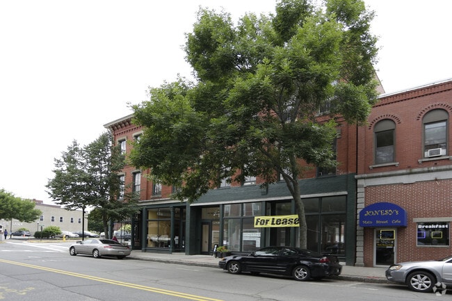
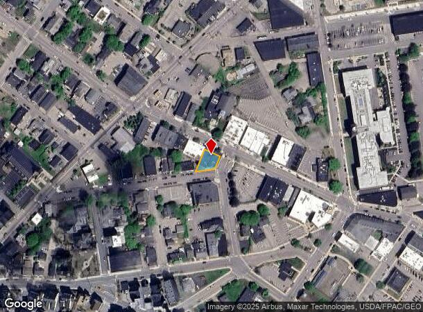
Property Record
265 Main St, Biddeford, ME 04005

NEARBY LISTINGS FOR SALE OR LEASE
Property Detail
265 Main St
BIDD-000038-000000-000139
York
Officebuilding
Maine
X
139
23031C0452G
0.13 AC
2024
York County
2024
Portland/South Portland
025206
Portland-South Portland, ME
14,432 SF
DEMOGRAPHICS near 265 Main St
1 Mile
3 Mile
5 Mile
2024 Total Population
17,066
34,299
53,111
2029 Population
17,884
35,975
56,381
Pop Growth 2024-2029
+ 4.79%
+ 4.89%
+ 6.16%
Average Age
39
42
43
2024 Total Households
7,959
15,232
23,770
HH Growth 2024-2029
+ 4.86%
+ 4.90%
+ 6.29%
Median Household Inc
$50,161
$59,607
$64,962
Avg Household Size
2.10
2.20
2.10
2024 Avg HH Vehicles
1.00
2.00
2.00
Median Home Value
$294,410
$311,579
$326,342
Median Year Built
1953
1972
1977
Nearby Places
Map Layers
Map Styles
 Street
 Aerial
- Restaurants
- Banks
- Shops
- Fitness
- Groceries
PUBLIC TRANSPORTATION
COMMUTER RAIL
DRIVE
WALK
Distance
2 min
15 min
0.8 mi
DRIVE
WALK
Distance
9 min
5.1 mi
AIRPORT
Portland International Jetport
DRIVE
WALK
Distance
Portland International Jetport
24 min
15.5 mi
Portsmouth International at Pease
DRIVE
WALK
Distance
Portsmouth International at Pease
50 min
38.0 mi
Freight Ports
Portland, ME
DRIVE
WALK
Distance
Portland, ME
25 min
18.1 mi
SALE & LEASE HISTORY
LISTING DATE
SALE/LEASE

Jan 27, 2023
For Lease
Jan 16, 2024
For Sale
Nearby Properties
Address
Land Use
TOTAL SIZE
Lot Size
Zoning
Address
Land Use
TOTAL SIZE
Lot Size
Zoning
25.99 AC
M
Address
Land Use
TOTAL SIZE
Lot Size
Zoning
10 AC
B-4
Address
Land Use
TOTAL SIZE
Lot Size
Zoning
233,280 SF
8.40 AC
MSRD3
Address
Land Use
TOTAL SIZE
Lot Size
Zoning
230,822 SF
3.50 AC
MSRD3
Address
Land Use
TOTAL SIZE
Lot Size
Zoning
8.47 AC
R1B
Address
Land Use
TOTAL SIZE
Lot Size
Zoning
69,442 SF
1.12 AC
B2
Address
Land Use
TOTAL SIZE
Lot Size
Zoning
Address
Land Use
TOTAL SIZE
Lot Size
Zoning
141.57 AC
I-1
Address
Land Use
TOTAL SIZE
Lot Size
Zoning
197,008 SF
44.47 AC
B1
Address
Land Use
TOTAL SIZE
Lot Size
Zoning
262,580 SF
40.10 AC
I1
Address
Land Use
TOTAL SIZE
Lot Size
Zoning
Address
Land Use
TOTAL SIZE
Lot Size
Zoning
224,607 SF
5.07 AC
B-4
Address
Land Use
TOTAL SIZE
Lot Size
Zoning
91,642 SF
21.43 AC
R1A
Address
Land Use
TOTAL SIZE
Lot Size
Zoning
122,465 SF
0.51 AC
MSRD3
Address
Land Use
TOTAL SIZE
Lot Size
Zoning
27.50 AC
R-1B
Address
Land Use
TOTAL SIZE
Lot Size
Zoning
136,348 SF
1.57 AC
MSRD3
Address
Land Use
TOTAL SIZE
Lot Size
Zoning
17.50 AC
B2
Address
Land Use
TOTAL SIZE
Lot Size
Zoning
119,500 SF
28.24 AC
B2
Address
Land Use
TOTAL SIZE
Lot Size
Zoning
Address
Land Use
TOTAL SIZE
Lot Size
Zoning
Address
Land Use
TOTAL SIZE
Lot Size
Zoning
35,008 SF
10.19 AC
RF SR1
Address
Land Use
TOTAL SIZE
Lot Size
Zoning
72,508 SF
2.57 AC
MSRD3
Address
Land Use
TOTAL SIZE
Lot Size
Zoning
11.40 AC
B-1
Address
Land Use
TOTAL SIZE
Lot Size
Zoning
708 SF
52.01 AC
R-4
Address
Land Use
TOTAL SIZE
Lot Size
Zoning
62,610 SF
2.61 AC
R-1A
Address
Land Use
TOTAL SIZE
Lot Size
Zoning
110 AC
R-1D
Address
Land Use
TOTAL SIZE
Lot Size
Zoning
77,406 SF
16 AC
R1A
Address
Land Use
TOTAL SIZE
Lot Size
Zoning
15.36 AC
I1
Address
Land Use
TOTAL SIZE
Lot Size
Zoning
64,788 SF
25.50 AC
R1A
Address
Land Use
TOTAL SIZE
Lot Size
Zoning
75,382 SF
0.85 AC
MSRD3
The World's #1 Commercial Real Estate Marketplace
Connect with us
© 2026 CoStar Group
The information above has been obtained from sources believed reliable. While we do not doubt its accuracy we have not verified it and make no guarantee, warranty or representation about it. It is your responsibility to independently confirm its accuracy and completeness. Any projections, opinions, assumptions, or estimates used are for example only and do not represent the current or future performance of the property. The value of this transaction to you depends on tax and other factors which should be evaluated by your tax, financial, and legal advisors. You and your advisors should conduct a careful, independent investigation of the property to determine to your satisfaction the suitability of the property for your needs.