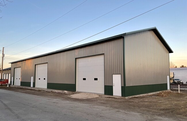
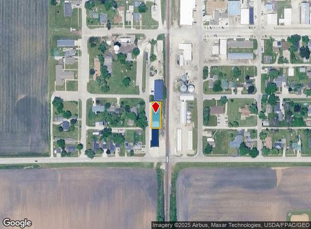
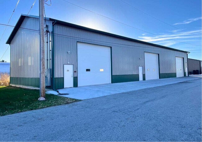
Property Record
265 Nw Garfield Ave, Elkhart, IA 50073
NEARBY LISTINGS FOR SALE OR LEASE
Property Detail
265 Nw Garfield Ave
Des Moines-West Des Moines, IA
Sec 28-81-23
211/00009-001-001
PARCEL 2021-188 BK 18826 PG 468 BNG PRT SE 1/4 SEC 28-81-23
Warehouse
Polk
0
Iowa
2025
0.17 AC
010101
Outlying Polk County
4,480 SF
Des Moines
DEMOGRAPHICS near 265 Nw Garfield Ave
1 Mile
3 Mile
5 Mile
2024 Total Population
1,085
2,414
21,696
2029 Population
1,139
2,539
22,720
Pop Growth 2024-2029
+ 4.98%
+ 5.18%
+ 4.72%
Average Age
39
39
37
2024 Total Households
411
887
8,349
HH Growth 2024-2029
+ 5.11%
+ 5.30%
+ 4.73%
Median Household Inc
$101,389
$114,999
$101,327
Avg Household Size
2.60
2.70
2.60
2024 Avg HH Vehicles
2.00
3.00
2.00
Median Home Value
$388,297
$387,217
$331,231
Median Year Built
1998
2000
2007
Nearby Places
Map Layers
Map Styles
 Street
 Aerial
- Restaurants
- Banks
- Shops
- Fitness
- Groceries
PUBLIC TRANSPORTATION
AIRPORT
Des Moines International
DRIVE
WALK
Distance
Des Moines International
37 min
23.5 mi
Freight Ports
Port Milwaukee
DRIVE
WALK
Distance
Port Milwaukee
420 min
374.4 mi
SALE & LEASE HISTORY
LISTING DATE
SALE/LEASE

Nov 13, 2023
For Lease
Nov 08, 2022
For Lease
Nearby Properties
Address
Land Use
TOTAL SIZE
Lot Size
Zoning
Address
Land Use
TOTAL SIZE
Lot Size
Zoning
192,668 SF
20.73 AC
Address
Land Use
TOTAL SIZE
Lot Size
Zoning
48,839 SF
16.05 AC
Address
Land Use
TOTAL SIZE
Lot Size
Zoning
36,178 SF
4.98 AC
Address
Land Use
TOTAL SIZE
Lot Size
Zoning
9,180 SF
8.02 AC
Address
Land Use
TOTAL SIZE
Lot Size
Zoning
19,396 SF
7.67 AC
Address
Land Use
TOTAL SIZE
Lot Size
Zoning
12,649 SF
1.79 AC
Address
Land Use
TOTAL SIZE
Lot Size
Zoning
23,400 SF
3.31 AC
Address
Land Use
TOTAL SIZE
Lot Size
Zoning
12,500 SF
5 AC
Address
Land Use
TOTAL SIZE
Lot Size
Zoning
11,040 SF
2.37 AC
Address
Land Use
TOTAL SIZE
Lot Size
Zoning
5,390 SF
7.97 AC
Address
Land Use
TOTAL SIZE
Lot Size
Zoning
1.76 AC
Address
Land Use
TOTAL SIZE
Lot Size
Zoning
14,260 SF
1.79 AC
R-3
Address
Land Use
TOTAL SIZE
Lot Size
Zoning
18,496 SF
1.38 AC
I-1
Address
Land Use
TOTAL SIZE
Lot Size
Zoning
26,496 SF
3.24 AC
I-1
Address
Land Use
TOTAL SIZE
Lot Size
Zoning
36 SF
10 AC
R-4
Address
Land Use
TOTAL SIZE
Lot Size
Zoning
1,960 SF
4.31 AC
Address
Land Use
TOTAL SIZE
Lot Size
Zoning
Address
Land Use
TOTAL SIZE
Lot Size
Zoning
98.54 AC
Address
Land Use
TOTAL SIZE
Lot Size
Zoning
8,670 SF
0.48 AC
C-1
Address
Land Use
TOTAL SIZE
Lot Size
Zoning
3,852 SF
38.96 AC
Address
Land Use
TOTAL SIZE
Lot Size
Zoning
8,200 SF
4.78 AC
AG
Address
Land Use
TOTAL SIZE
Lot Size
Zoning
Address
Land Use
TOTAL SIZE
Lot Size
Zoning
3.56 AC
Address
Land Use
TOTAL SIZE
Lot Size
Zoning
4,200 SF
0.17 AC
I1
Address
Land Use
TOTAL SIZE
Lot Size
Zoning
65.98 AC
Address
Land Use
TOTAL SIZE
Lot Size
Zoning
3,600 SF
0.27 AC
Address
Land Use
TOTAL SIZE
Lot Size
Zoning
3,600 SF
0.27 AC
Address
Land Use
TOTAL SIZE
Lot Size
Zoning
2.68 AC
Address
Land Use
TOTAL SIZE
Lot Size
Zoning
5,330 SF
0.43 AC
R-3
The World's #1 Commercial Real Estate Marketplace
Connect with us
© 2025 CoStar Group
The information above has been obtained from sources believed reliable. While we do not doubt its accuracy we have not verified it and make no guarantee, warranty or representation about it. It is your responsibility to independently confirm its accuracy and completeness. Any projections, opinions, assumptions, or estimates used are for example only and do not represent the current or future performance of the property. The value of this transaction to you depends on tax and other factors which should be evaluated by your tax, financial, and legal advisors. You and your advisors should conduct a careful, independent investigation of the property to determine to your satisfaction the suitability of the property for your needs.