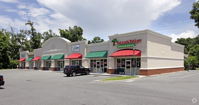
Property Record
265 Sw Malone St, Lake City, FL 32025

NEARBY LISTINGS FOR SALE OR LEASE
Property Detail
265 Sw Malone St
Lake City, FL
Marion Place Office Park
05-4S-17-07610-201
LOT 1 MARION PLACE OFFICE PARK
Regionalshoppingcenterormallwithanchorstore
Columbia
X
Florida
12023C0292D
1
2024
1.28 AC
2026
Florida Central North Area
110700
Other Market Areas
9,348 SF
DEMOGRAPHICS near 265 Sw Malone St
1 Mile
3 Mile
5 Mile
2024 Total Population
2,301
21,338
36,058
2029 Population
2,411
22,459
37,996
Pop Growth 2024-2029
+ 4.78%
+ 5.25%
+ 5.37%
Average Age
42
40
41
2024 Total Households
915
8,391
13,751
HH Growth 2024-2029
+ 5.14%
+ 5.65%
+ 5.88%
Median Household Inc
$58,571
$49,643
$53,053
Avg Household Size
2.30
2.40
2.40
2024 Avg HH Vehicles
2.00
2.00
2.00
Median Home Value
$181,779
$160,189
$175,026
Median Year Built
1985
1982
1986
Nearby Places
Map Layers
Map Styles
 Street
 Aerial
- Restaurants
- Banks
- Shops
- Fitness
- Groceries
PUBLIC TRANSPORTATION
AIRPORT
Gainesville Regional
DRIVE
WALK
Distance
Gainesville Regional
63 min
45.6 mi
SALE & LEASE HISTORY
LISTING DATE
SALE/LEASE

Oct 13, 2017
For Lease
Nearby Properties
Address
Land Use
TOTAL SIZE
Lot Size
Zoning
Address
Land Use
TOTAL SIZE
Lot Size
Zoning
800,000 SF
35.90 AC
RO
Address
Land Use
TOTAL SIZE
Lot Size
Zoning
11.98 AC
RSF-2
Address
Land Use
TOTAL SIZE
Lot Size
Zoning
167,663 SF
11.62 AC
RMF-2
Address
Land Use
TOTAL SIZE
Lot Size
Zoning
211,645 SF
41 AC
A-1
Address
Land Use
TOTAL SIZE
Lot Size
Zoning
112,272 SF
6.08 AC
RO
Address
Land Use
TOTAL SIZE
Lot Size
Zoning
220,228 SF
22.22 AC
CG
Address
Land Use
TOTAL SIZE
Lot Size
Zoning
31,758 SF
2.59 AC
CHI
Address
Land Use
TOTAL SIZE
Lot Size
Zoning
79,425 SF
2.66 AC
CG
Address
Land Use
TOTAL SIZE
Lot Size
Zoning
144,355 SF
49 AC
RSFMH2
Address
Land Use
TOTAL SIZE
Lot Size
Zoning
142,790 SF
27.87 AC
RSF-2
Address
Land Use
TOTAL SIZE
Lot Size
Zoning
71,293 SF
10.17 AC
CI
Address
Land Use
TOTAL SIZE
Lot Size
Zoning
20.08 AC
Address
Land Use
TOTAL SIZE
Lot Size
Zoning
59,778 SF
4.51 AC
CG
Address
Land Use
TOTAL SIZE
Lot Size
Zoning
127,012 SF
25.19 AC
Address
Land Use
TOTAL SIZE
Lot Size
Zoning
112,471 SF
15.66 AC
CG
Address
Land Use
TOTAL SIZE
Lot Size
Zoning
310,629 SF
33.79 AC
Address
Land Use
TOTAL SIZE
Lot Size
Zoning
44,124 SF
53 AC
Address
Land Use
TOTAL SIZE
Lot Size
Zoning
133,076 SF
14.57 AC
A-1
Address
Land Use
TOTAL SIZE
Lot Size
Zoning
47,552 SF
5.73 AC
CI
Address
Land Use
TOTAL SIZE
Lot Size
Zoning
18,603 SF
1.70 AC
CHI
Address
Land Use
TOTAL SIZE
Lot Size
Zoning
66,346 SF
7.75 AC
RSF-3
Address
Land Use
TOTAL SIZE
Lot Size
Zoning
83,595 SF
1.01 AC
C-CBD
Address
Land Use
TOTAL SIZE
Lot Size
Zoning
55,456 SF
2.32 AC
CG
Address
Land Use
TOTAL SIZE
Lot Size
Zoning
141,355 SF
27 AC
RSFMH2
Address
Land Use
TOTAL SIZE
Lot Size
Zoning
81,848 SF
3.28 AC
RMF-1
Address
Land Use
TOTAL SIZE
Lot Size
Zoning
202,532 SF
12.95 AC
RMF-2
Address
Land Use
TOTAL SIZE
Lot Size
Zoning
26,676 SF
3 AC
CG
Address
Land Use
TOTAL SIZE
Lot Size
Zoning
77,731 SF
23.50 AC
RSF-2
Address
Land Use
TOTAL SIZE
Lot Size
Zoning
42,004 SF
40.40 AC
CG
Address
Land Use
TOTAL SIZE
Lot Size
Zoning
58,236 SF
2 AC
CG
The World's #1 Commercial Real Estate Marketplace
Connect with us
© 2026 CoStar Group
The information above has been obtained from sources believed reliable. While we do not doubt its accuracy we have not verified it and make no guarantee, warranty or representation about it. It is your responsibility to independently confirm its accuracy and completeness. Any projections, opinions, assumptions, or estimates used are for example only and do not represent the current or future performance of the property. The value of this transaction to you depends on tax and other factors which should be evaluated by your tax, financial, and legal advisors. You and your advisors should conduct a careful, independent investigation of the property to determine to your satisfaction the suitability of the property for your needs.