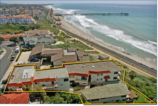
Property Record
265 W Marquita, San Clemente, CA 92672


NEARBY LISTINGS FOR SALE OR LEASE
Property Detail
265 W Marquita
692-095-05
N TR 793 BLK 17 LOT 25
Multifamilydwelling
Orange
X
California
06073C0100G
25
2024
0.44 AC
2025
South County
042108
Orange County (California)
9,680 SF
Anaheim-Santa Ana-Irvine, CA
DEMOGRAPHICS near 265 W Marquita
1 Mile
3 Mile
5 Mile
2024 Total Population
14,777
49,012
88,763
2029 Population
14,893
48,968
88,414
Pop Growth 2024-2029
+ 0.79%
(0.09%)
(0.39%)
Average Age
40
44
42
2024 Total Households
6,296
19,832
32,847
HH Growth 2024-2029
+ 0.86%
(0.09%)
(0.38%)
Median Household Inc
$92,122
$112,940
$121,995
Avg Household Size
2.30
2.40
2.60
2024 Avg HH Vehicles
2.00
2.00
2.00
Median Home Value
$1,100,630
$1,065,678
$1,055,072
Median Year Built
1970
1977
1981
Nearby Places
Map Layers
Map Styles
 Street
 Aerial
- Restaurants
- Banks
- Shops
- Fitness
- Groceries
PUBLIC TRANSPORTATION
TRANSIT/SUBWAY
San Clemente Pier (Orange County Line - Southern California Regional Rail Authority (Metrolink))
DRIVE
WALK
Distance
San Clemente Pier (Orange County Line - Southern California Regional Rail Authority (Metrolink))
4 min
12 min
0.6 mi
COMMUTER RAIL
San Clemente Pier (Orange County Line - Southern California Regional Rail Authority (Metrolink))
DRIVE
WALK
Distance
San Clemente Pier (Orange County Line - Southern California Regional Rail Authority (Metrolink))
4 min
12 min
0.6 mi
DRIVE
WALK
Distance
5 min
1.4 mi
AIRPORT
John Wayne/Orange County
DRIVE
WALK
Distance
John Wayne/Orange County
35 min
27.8 mi
Long Beach (Daugherty Field)
DRIVE
WALK
Distance
Long Beach (Daugherty Field)
58 min
47.8 mi
Freight Ports
Port of Long Beach
DRIVE
WALK
Distance
Port of Long Beach
63 min
47.4 mi
Nearby Properties
Address
Land Use
TOTAL SIZE
Lot Size
Zoning
Address
Land Use
TOTAL SIZE
Lot Size
Zoning
Address
Land Use
TOTAL SIZE
Lot Size
Zoning
Address
Land Use
TOTAL SIZE
Lot Size
Zoning
Address
Land Use
TOTAL SIZE
Lot Size
Zoning
17.29 AC
Address
Land Use
TOTAL SIZE
Lot Size
Zoning
Address
Land Use
TOTAL SIZE
Lot Size
Zoning
Address
Land Use
TOTAL SIZE
Lot Size
Zoning
Address
Land Use
TOTAL SIZE
Lot Size
Zoning
Address
Land Use
TOTAL SIZE
Lot Size
Zoning
Address
Land Use
TOTAL SIZE
Lot Size
Zoning
Address
Land Use
TOTAL SIZE
Lot Size
Zoning
1,458 SF
11.59 AC
Address
Land Use
TOTAL SIZE
Lot Size
Zoning
Address
Land Use
TOTAL SIZE
Lot Size
Zoning
Address
Land Use
TOTAL SIZE
Lot Size
Zoning
Address
Land Use
TOTAL SIZE
Lot Size
Zoning
61,317 SF
3.62 AC
C3
Address
Land Use
TOTAL SIZE
Lot Size
Zoning
Address
Land Use
TOTAL SIZE
Lot Size
Zoning
12,768 SF
0.60 AC
C
Address
Land Use
TOTAL SIZE
Lot Size
Zoning
5,256 SF
1.48 AC
Address
Land Use
TOTAL SIZE
Lot Size
Zoning
31,500 SF
1.13 AC
OP
Address
Land Use
TOTAL SIZE
Lot Size
Zoning
Address
Land Use
TOTAL SIZE
Lot Size
Zoning
Address
Land Use
TOTAL SIZE
Lot Size
Zoning
Address
Land Use
TOTAL SIZE
Lot Size
Zoning
10.75 AC
Address
Land Use
TOTAL SIZE
Lot Size
Zoning
Address
Land Use
TOTAL SIZE
Lot Size
Zoning
43.55 AC
Address
Land Use
TOTAL SIZE
Lot Size
Zoning
Address
Land Use
TOTAL SIZE
Lot Size
Zoning
Address
Land Use
TOTAL SIZE
Lot Size
Zoning
9,843 SF
2.39 AC
Address
Land Use
TOTAL SIZE
Lot Size
Zoning
Address
Land Use
TOTAL SIZE
Lot Size
Zoning
The World's #1 Commercial Real Estate Marketplace
Connect with us
© 2025 CoStar Group
The information above has been obtained from sources believed reliable. While we do not doubt its accuracy we have not verified it and make no guarantee, warranty or representation about it. It is your responsibility to independently confirm its accuracy and completeness. Any projections, opinions, assumptions, or estimates used are for example only and do not represent the current or future performance of the property. The value of this transaction to you depends on tax and other factors which should be evaluated by your tax, financial, and legal advisors. You and your advisors should conduct a careful, independent investigation of the property to determine to your satisfaction the suitability of the property for your needs.