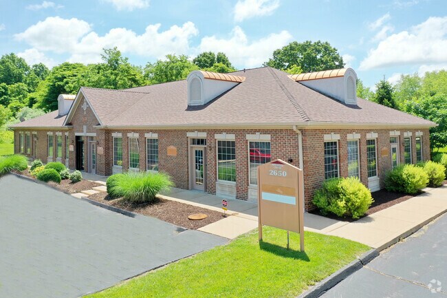
Property Record
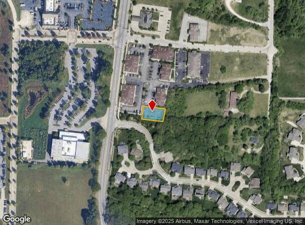
2650 Highway 109 Grover St, Grover, MO 63040

NEARBY LISTINGS FOR SALE OR LEASE
Property Detail
2650 Highway 109 Grover St
St. Louis, MO-IL
Westridge Office Center Resubdivision
24V-4-2-050-6
WESTRIDGE OFFICE CENTER RESUBDIVISION LOT 4
Officebuilding
St. Louis
X
Missouri
29071C0225E
4
2024
0.25 AC
2025
West County
222100
St. Louis
4,968 SF
DEMOGRAPHICS near 2650 Highway 109 Grover St
1 Mile
3 Mile
5 Mile
2024 Total Population
3,861
25,710
65,078
2029 Population
3,830
25,110
63,754
Pop Growth 2024-2029
(0.80%)
(2.33%)
(2.03%)
Average Age
41
42
42
2024 Total Households
1,570
9,481
23,825
HH Growth 2024-2029
(0.89%)
(2.36%)
(2.07%)
Median Household Inc
$97,883
$131,963
$130,214
Avg Household Size
2.40
2.70
2.70
2024 Avg HH Vehicles
2.00
2.00
2.00
Median Home Value
$341,282
$385,826
$391,594
Median Year Built
1993
1991
1989
Nearby Places
Map Layers
Map Styles
 Street
 Aerial
- Restaurants
- Banks
- Shops
- Fitness
- Groceries
PUBLIC TRANSPORTATION
AIRPORT
St Louis Lambert International
DRIVE
WALK
Distance
St Louis Lambert International
45 min
29.2 mi
SALE & LEASE HISTORY
LISTING DATE
SALE/LEASE

Mar 13, 2019
For Sale
Jun 25, 2018
For Lease
Jun 06, 2019
For Lease
Aug 25, 2020
For Lease
Nearby Properties
Address
Land Use
TOTAL SIZE
Lot Size
Zoning
Address
Land Use
TOTAL SIZE
Lot Size
Zoning
51.20 AC
NU
Address
Land Use
TOTAL SIZE
Lot Size
Zoning
5,675 SF
1,382.01 AC
PS
Address
Land Use
TOTAL SIZE
Lot Size
Zoning
85,946 SF
60.44 AC
NU
Address
Land Use
TOTAL SIZE
Lot Size
Zoning
313,104 SF
14.66 AC
MXD
Address
Land Use
TOTAL SIZE
Lot Size
Zoning
138,056 SF
17.42 AC
NU
Address
Land Use
TOTAL SIZE
Lot Size
Zoning
27.86 AC
107NU
Address
Land Use
TOTAL SIZE
Lot Size
Zoning
78.78 AC
107NU
Address
Land Use
TOTAL SIZE
Lot Size
Zoning
68.69 AC
107NU
Address
Land Use
TOTAL SIZE
Lot Size
Zoning
30 AC
107NU
Address
Land Use
TOTAL SIZE
Lot Size
Zoning
16.80 AC
NU
Address
Land Use
TOTAL SIZE
Lot Size
Zoning
164,430 SF
9.85 AC
19C-4
Address
Land Use
TOTAL SIZE
Lot Size
Zoning
247,511 SF
31.03 AC
19M-1
Address
Land Use
TOTAL SIZE
Lot Size
Zoning
3,750 SF
169.58 AC
107NU
Address
Land Use
TOTAL SIZE
Lot Size
Zoning
4,464 SF
12.30 AC
107NU
Address
Land Use
TOTAL SIZE
Lot Size
Zoning
185,087 SF
8 AC
19C-4
Address
Land Use
TOTAL SIZE
Lot Size
Zoning
118,097 SF
14.32 AC
19C-4
Address
Land Use
TOTAL SIZE
Lot Size
Zoning
97,285 SF
13.66 AC
19R-1
Address
Land Use
TOTAL SIZE
Lot Size
Zoning
222,707 SF
13.82 AC
19C-1
Address
Land Use
TOTAL SIZE
Lot Size
Zoning
109,550 SF
14.21 AC
107R6A
Address
Land Use
TOTAL SIZE
Lot Size
Zoning
7,208 SF
29.36 AC
107NU
Address
Land Use
TOTAL SIZE
Lot Size
Zoning
17.18 AC
R1A
Address
Land Use
TOTAL SIZE
Lot Size
Zoning
11.91 AC
107R3
Address
Land Use
TOTAL SIZE
Lot Size
Zoning
9.89 AC
19R-1
Address
Land Use
TOTAL SIZE
Lot Size
Zoning
12.76 AC
A
Address
Land Use
TOTAL SIZE
Lot Size
Zoning
37.37 AC
107NU
Address
Land Use
TOTAL SIZE
Lot Size
Zoning
73,053 SF
1.65 AC
107NU
Address
Land Use
TOTAL SIZE
Lot Size
Zoning
50,846 SF
6.52 AC
107NU
Address
Land Use
TOTAL SIZE
Lot Size
Zoning
15.82 AC
107NU
Address
Land Use
TOTAL SIZE
Lot Size
Zoning
89,832 SF
10.68 AC
19C-4
Address
Land Use
TOTAL SIZE
Lot Size
Zoning
42,657 SF
5.86 AC
19C-4
The World's #1 Commercial Real Estate Marketplace
Connect with us
© 2025 CoStar Group
The information above has been obtained from sources believed reliable. While we do not doubt its accuracy we have not verified it and make no guarantee, warranty or representation about it. It is your responsibility to independently confirm its accuracy and completeness. Any projections, opinions, assumptions, or estimates used are for example only and do not represent the current or future performance of the property. The value of this transaction to you depends on tax and other factors which should be evaluated by your tax, financial, and legal advisors. You and your advisors should conduct a careful, independent investigation of the property to determine to your satisfaction the suitability of the property for your needs.