Property Record
S Grade Rd, Alpine, CA 91901

This Property Is For Sale
Property Detail
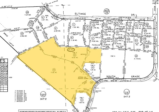
S Grade Rd
404-430-45
PAR 2 PAR B OF DOC05-0423284 IN PARS 1& TR PM15195
Residentialacreage
SAN DIEGO
A70
California
B and X Area of moderate flood hazard, usually the area between the limits of the 100-year and 500-year floods.
11.52 AC
2024
Outlying SD County S
2025
San Diego
021204
San Diego-Chula Vista-Carlsbad, CA
NEARBY LISTINGS FOR SALE OR LEASE
DEMOGRAPHICS near S Grade Rd
1 mile
3 mile
5 mile
2025 Total Population
5,058
14,579
19,982
2030 Population
5,065
14,596
19,994
Pop Growth 2025-2030
+ 0.14%
+ 0.12%
+ 0.06%
Average Age
40
42
43
2025 Total Households
1,875
5,233
7,133
HH Growth 2025-2030
(0.05%)
(0.02%)
(0.10%)
Median Household Inc
$100,902
$119,333
$122,026
Avg Household Size
2.70
2.70
2.70
2025 Avg HH Vehicles
2.00
2.00
2.00
Median Home Value
$739,945
$816,118
$821,892
Median Year Built
1985
1987
1987
Nearby Places
Map Layers
Map Styles
 Street
 Aerial
Transit
 Traffic
 Biking
Places
Listings with unknown addresses are not visible on the map
- Restaurants
- Banks
- Shops
- Fitness
- Groceries
Nearby Properties
Address
Land Use
TOTAL SIZE
Lot Size
Zoning
Address
Land Use
TOTAL SIZE
Lot Size
Zoning
30.54 AC
RV
Address
Land Use
TOTAL SIZE
Lot Size
Zoning
72,864 SF
4.50 AC
RM
Address
Land Use
TOTAL SIZE
Lot Size
Zoning
14.05 AC
RU
Address
Land Use
TOTAL SIZE
Lot Size
Zoning
52,525 SF
6.90 AC
C36
Address
Land Use
TOTAL SIZE
Lot Size
Zoning
4.83 AC
RV
Address
Land Use
TOTAL SIZE
Lot Size
Zoning
8.70 AC
RS
Address
Land Use
TOTAL SIZE
Lot Size
Zoning
47,195 SF
3.42 AC
C37
Address
Land Use
TOTAL SIZE
Lot Size
Zoning
57,457 SF
6.91 AC
C36
Address
Land Use
TOTAL SIZE
Lot Size
Zoning
57,350 SF
3.21 AC
RU
Address
Land Use
TOTAL SIZE
Lot Size
Zoning
17,597 SF
21.22 AC
A70
Address
Land Use
TOTAL SIZE
Lot Size
Zoning
31,412 SF
4.09 AC
C34
Address
Land Use
TOTAL SIZE
Lot Size
Zoning
27,288 SF
1.71 AC
ALV1
Address
Land Use
TOTAL SIZE
Lot Size
Zoning
6.04 AC
ALV1
Address
Land Use
TOTAL SIZE
Lot Size
Zoning
12,176 SF
5.12 AC
A70
Address
Land Use
TOTAL SIZE
Lot Size
Zoning
15,748 SF
0.50 AC
C36
Address
Land Use
TOTAL SIZE
Lot Size
Zoning
3.60 AC
RU
Address
Land Use
TOTAL SIZE
Lot Size
Zoning
8,400 SF
5 AC
A70
Address
Land Use
TOTAL SIZE
Lot Size
Zoning
34,303 SF
2.65 AC
C36
Address
Land Use
TOTAL SIZE
Lot Size
Zoning
16,708 SF
2.49 AC
C36
Address
Land Use
TOTAL SIZE
Lot Size
Zoning
49,961 SF
1.25 AC
M52
Address
Land Use
TOTAL SIZE
Lot Size
Zoning
22,104 SF
0.83 AC
ALV1
Address
Land Use
TOTAL SIZE
Lot Size
Zoning
45,678 SF
2.92 AC
RU
Address
Land Use
TOTAL SIZE
Lot Size
Zoning
32,000 SF
2.40 AC
C36
Address
Land Use
TOTAL SIZE
Lot Size
Zoning
2.22 AC
RU
Address
Land Use
TOTAL SIZE
Lot Size
Zoning
2.23 AC
RU
Address
Land Use
TOTAL SIZE
Lot Size
Zoning
26,616 SF
1.98 AC
M52
Address
Land Use
TOTAL SIZE
Lot Size
Zoning
5.44 AC
A70
Address
Land Use
TOTAL SIZE
Lot Size
Zoning
23,720 SF
2.57 AC
C36
Address
Land Use
TOTAL SIZE
Lot Size
Zoning
2,500 SF
8.60 AC
RMH8
Address
Land Use
TOTAL SIZE
Lot Size
Zoning
41,364 SF
1.31 AC
RV
The World's #1 Commercial Real Estate Marketplace
Connect with us
© 2026 CoStar Group
The information above has been obtained from sources believed reliable. While we do not doubt its accuracy we have not verified it and make no guarantee, warranty or representation about it. It is your responsibility to independently confirm its accuracy and completeness. Any projections, opinions, assumptions, or estimates used are for example only and do not represent the current or future performance of the property. The value of this transaction to you depends on tax and other factors which should be evaluated by your tax, financial, and legal advisors. You and your advisors should conduct a careful, independent investigation of the property to determine to your satisfaction the suitability of the property for your needs.