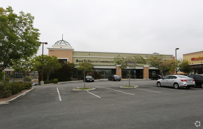
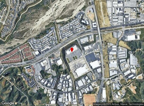
Property Record
26501 Carl Boyer Dr, Santa Clarita, CA 91350


NEARBY LISTINGS FOR SALE OR LEASE
Property Detail
26501 Carl Boyer Dr
Los Angeles-Long Beach-Glendale, CA
42670-09
2836-016-044
TR=42670-09 LOT 1
Regionalshoppingcenterormallwithanchorstore
Los Angeles
X
California
06037C0817G
1
2024
23.25 AC
2025
Santa Clarita Valley
920314
Los Angeles
129,420 SF
DEMOGRAPHICS near 26501 Carl Boyer Dr
1 Mile
3 Mile
5 Mile
2024 Total Population
7,173
109,086
219,637
2029 Population
6,865
105,109
211,700
Pop Growth 2024-2029
(4.29%)
(3.65%)
(3.61%)
Average Age
40
40
39
2024 Total Households
2,292
36,158
73,289
HH Growth 2024-2029
(4.67%)
(3.89%)
(3.84%)
Median Household Inc
$98,663
$103,285
$110,648
Avg Household Size
3.00
2.90
2.90
2024 Avg HH Vehicles
2.00
2.00
2.00
Median Home Value
$571,218
$679,517
$711,251
Median Year Built
1991
1985
1988
Nearby Places
Map Layers
Map Styles
 Street
 Aerial
- Restaurants
- Banks
- Shops
- Fitness
- Groceries
PUBLIC TRANSPORTATION
COMMUTER RAIL
Santa Clarita (Antelope Valley Line - Southern California Regional Rail Authority (Metrolink))
DRIVE
WALK
Distance
Santa Clarita (Antelope Valley Line - Southern California Regional Rail Authority (Metrolink))
4 min
1.5 mi
Via Princessa (Antelope Valley Line - Southern California Regional Rail Authority (Metrolink))
DRIVE
WALK
Distance
Via Princessa (Antelope Valley Line - Southern California Regional Rail Authority (Metrolink))
7 min
3.5 mi
AIRPORT
Bob Hope
DRIVE
WALK
Distance
Bob Hope
29 min
20.7 mi
Freight Ports
The Port of Hueneme
DRIVE
WALK
Distance
The Port of Hueneme
79 min
55.0 mi
Nearby Properties
Address
Land Use
TOTAL SIZE
Lot Size
Zoning
Address
Land Use
TOTAL SIZE
Lot Size
Zoning
491,654 SF
17.56 AC
SCPI
Address
Land Use
TOTAL SIZE
Lot Size
Zoning
479,178 SF
14.17 AC
SCCR
Address
Land Use
TOTAL SIZE
Lot Size
Zoning
495,604 SF
38.40 AC
SCI
Address
Land Use
TOTAL SIZE
Lot Size
Zoning
255,744 SF
8.33 AC
SCUR3
Address
Land Use
TOTAL SIZE
Lot Size
Zoning
161,103 SF
4.68 AC
SCUR4
Address
Land Use
TOTAL SIZE
Lot Size
Zoning
402,480 SF
13.58 AC
SCCN
Address
Land Use
TOTAL SIZE
Lot Size
Zoning
103,828 SF
6.23 AC
SCUR4
Address
Land Use
TOTAL SIZE
Lot Size
Zoning
2,355 SF
497.82 AC
SCSP
Address
Land Use
TOTAL SIZE
Lot Size
Zoning
131,425 SF
0.82 AC
SCCR
Address
Land Use
TOTAL SIZE
Lot Size
Zoning
196,958 SF
14.03 AC
SCUR5
Address
Land Use
TOTAL SIZE
Lot Size
Zoning
97,780 SF
14.98 AC
SCUR3
Address
Land Use
TOTAL SIZE
Lot Size
Zoning
216,067 SF
25.69 AC
SCBP
Address
Land Use
TOTAL SIZE
Lot Size
Zoning
86,201 SF
3.68 AC
SCUR4
Address
Land Use
TOTAL SIZE
Lot Size
Zoning
245,606 SF
11.67 AC
SCUR4
Address
Land Use
TOTAL SIZE
Lot Size
Zoning
3,840 SF
443.36 AC
SCSP
Address
Land Use
TOTAL SIZE
Lot Size
Zoning
350,399 SF
6.93 AC
SCCR
Address
Land Use
TOTAL SIZE
Lot Size
Zoning
354,338 SF
26.37 AC
SCCR
Address
Land Use
TOTAL SIZE
Lot Size
Zoning
180,492 SF
9.47 AC
SCUR4
Address
Land Use
TOTAL SIZE
Lot Size
Zoning
79,622 SF
1.21 AC
SCPI
Address
Land Use
TOTAL SIZE
Lot Size
Zoning
52,904 SF
3.08 AC
SCPI
Address
Land Use
TOTAL SIZE
Lot Size
Zoning
78,110 SF
0.73 AC
SCCR
Address
Land Use
TOTAL SIZE
Lot Size
Zoning
60,614 SF
1.05 AC
SCCR
Address
Land Use
TOTAL SIZE
Lot Size
Zoning
76,039 SF
11.30 AC
SCCC
Address
Land Use
TOTAL SIZE
Lot Size
Zoning
57,300 SF
6.89 AC
SCCC
Address
Land Use
TOTAL SIZE
Lot Size
Zoning
154,374 SF
15.47 AC
SCBP
Address
Land Use
TOTAL SIZE
Lot Size
Zoning
74,176 SF
6.89 AC
SCUR3
Address
Land Use
TOTAL SIZE
Lot Size
Zoning
347,378 SF
14.11 AC
SCCP
Address
Land Use
TOTAL SIZE
Lot Size
Zoning
154,463 SF
4.82 AC
SCCR
The World's #1 Commercial Real Estate Marketplace
Connect with us
© 2026 CoStar Group
The information above has been obtained from sources believed reliable. While we do not doubt its accuracy we have not verified it and make no guarantee, warranty or representation about it. It is your responsibility to independently confirm its accuracy and completeness. Any projections, opinions, assumptions, or estimates used are for example only and do not represent the current or future performance of the property. The value of this transaction to you depends on tax and other factors which should be evaluated by your tax, financial, and legal advisors. You and your advisors should conduct a careful, independent investigation of the property to determine to your satisfaction the suitability of the property for your needs.