Property Record
2651 Northrise Dr, Las Cruces, NM 88011

NEARBY LISTINGS FOR SALE OR LEASE
-
-
View all Las Cruces listings for sale on LoopNet.com
Property Detail
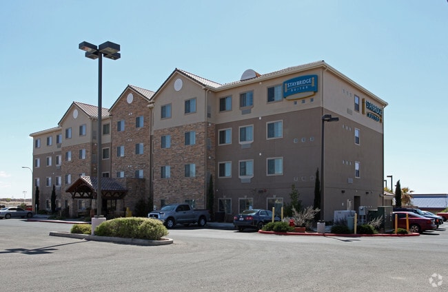
2651 Northrise Dr
02-24500
Northrise Business Park Parcel No 8
Commercialacreage
S: 32 T: 22S R: 2E PT OF SWQTR
X
Dona Ana
35013C1082G
New Mexico
2024
2.37 AC
2025
Las Cruces/Alamogordo
001206
Other Market Areas
92,043 SF
Las Cruces, NM
DEMOGRAPHICS near 2651 Northrise Dr
1 Mile
3 Mile
5 Mile
2024 Total Population
7,861
66,651
130,066
2029 Population
8,281
70,499
137,249
Pop Growth 2024-2029
+ 5.34%
+ 5.77%
+ 5.52%
Average Age
39
39
38
2024 Total Households
3,421
26,826
51,804
HH Growth 2024-2029
+ 5.44%
+ 5.85%
+ 5.61%
Median Household Inc
$63,824
$54,935
$47,311
Avg Household Size
2.30
2.40
2.40
2024 Avg HH Vehicles
2.00
2.00
2.00
Median Home Value
$198,069
$197,862
$191,486
Median Year Built
1997
1996
1990
Nearby Places
Map Layers
Map Styles
 Street
 Aerial
- Restaurants
- Banks
- Shops
- Fitness
- Groceries
SALE & LEASE HISTORY
LISTING DATE
SALE/LEASE

Oct 05, 2020
For Sale
Nearby Properties
Address
Land Use
TOTAL SIZE
Lot Size
Zoning
Address
Land Use
TOTAL SIZE
Lot Size
Zoning
266,671 SF
23.96 AC
PUD
Address
Land Use
TOTAL SIZE
Lot Size
Zoning
106,866 SF
10.61 AC
R1
Address
Land Use
TOTAL SIZE
Lot Size
Zoning
280,731 SF
15.55 AC
PUD
Address
Land Use
TOTAL SIZE
Lot Size
Zoning
29,466 SF
1.33 AC
C2
Address
Land Use
TOTAL SIZE
Lot Size
Zoning
78,452 SF
60 AC
A2
Address
Land Use
TOTAL SIZE
Lot Size
Zoning
66,410 SF
7 AC
PUD
Address
Land Use
TOTAL SIZE
Lot Size
Zoning
6,232 SF
22.74 AC
C2
Address
Land Use
TOTAL SIZE
Lot Size
Zoning
154,592 SF
14.12 AC
A2
Address
Land Use
TOTAL SIZE
Lot Size
Zoning
170,972 SF
16.38 AC
R4
Address
Land Use
TOTAL SIZE
Lot Size
Zoning
195,560 SF
25.05 AC
PUD
Address
Land Use
TOTAL SIZE
Lot Size
Zoning
135,605 SF
6 AC
PUD
Address
Land Use
TOTAL SIZE
Lot Size
Zoning
98,015 SF
7.85 AC
A1
Address
Land Use
TOTAL SIZE
Lot Size
Zoning
49,295 SF
6.29 AC
R3
Address
Land Use
TOTAL SIZE
Lot Size
Zoning
7,483 SF
16.15 AC
PUD
Address
Land Use
TOTAL SIZE
Lot Size
Zoning
65,535 SF
5.64 AC
R1
Address
Land Use
TOTAL SIZE
Lot Size
Zoning
14.47 AC
R4
Address
Land Use
TOTAL SIZE
Lot Size
Zoning
78,845 SF
14.81 AC
A2
Address
Land Use
TOTAL SIZE
Lot Size
Zoning
132,179 SF
14.24 AC
M1
Address
Land Use
TOTAL SIZE
Lot Size
Zoning
42,295 SF
7.45 AC
C2
Address
Land Use
TOTAL SIZE
Lot Size
Zoning
44,506 SF
C2
Address
Land Use
TOTAL SIZE
Lot Size
Zoning
119,985 SF
6 AC
R1
Address
Land Use
TOTAL SIZE
Lot Size
Zoning
136,629 SF
15.78 AC
C2
Address
Land Use
TOTAL SIZE
Lot Size
Zoning
79,362 SF
5.90 AC
C2
Address
Land Use
TOTAL SIZE
Lot Size
Zoning
62,645 SF
5.50 AC
R3
Address
Land Use
TOTAL SIZE
Lot Size
Zoning
17,812 SF
2.65 AC
CBD
Address
Land Use
TOTAL SIZE
Lot Size
Zoning
100,145 SF
8.46 AC
C2
Address
Land Use
TOTAL SIZE
Lot Size
Zoning
102,505 SF
6.44 AC
PUD
Address
Land Use
TOTAL SIZE
Lot Size
Zoning
21,048 SF
22.24 AC
C2
The World's #1 Commercial Real Estate Marketplace
Connect with us
© 2026 CoStar Group
The information above has been obtained from sources believed reliable. While we do not doubt its accuracy we have not verified it and make no guarantee, warranty or representation about it. It is your responsibility to independently confirm its accuracy and completeness. Any projections, opinions, assumptions, or estimates used are for example only and do not represent the current or future performance of the property. The value of this transaction to you depends on tax and other factors which should be evaluated by your tax, financial, and legal advisors. You and your advisors should conduct a careful, independent investigation of the property to determine to your satisfaction the suitability of the property for your needs.