Property Record
2651 State Route 72, Jonestown, PA 17038

NEARBY LISTINGS FOR SALE OR LEASE
Property Detail
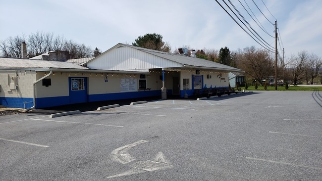
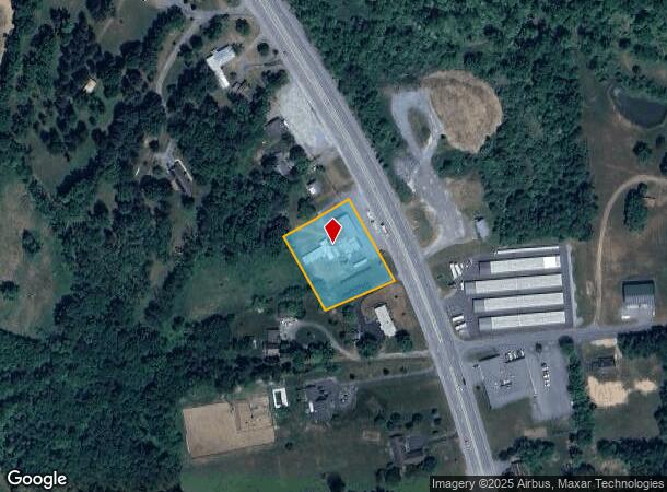
2651 State Route 72
33-2316058-400528-0000
Land Subdivision Plan For Paul E Adams &
Restaurantbuilding
Lebanon
X
Pennsylvania
42075C0120E
1 AC
2025
Lebanon
2025
Philadelphia
002000
Lebanon, PA
7,960 SF
DEMOGRAPHICS near 2651 State Route 72
1 Mile
3 Mile
5 Mile
2024 Total Population
536
8,179
16,030
2029 Population
541
8,202
16,119
Pop Growth 2024-2029
+ 0.93%
+ 0.28%
+ 0.56%
Average Age
42
41
41
2024 Total Households
209
3,105
6,081
HH Growth 2024-2029
+ 0.96%
+ 0.32%
+ 0.59%
Median Household Inc
$77,027
$74,999
$80,662
Avg Household Size
2.60
2.60
2.60
2024 Avg HH Vehicles
2.00
2.00
2.00
Median Home Value
$241,176
$230,861
$229,796
Median Year Built
1975
1976
1976
Nearby Places
Map Layers
Map Styles
 Street
 Aerial
- Restaurants
- Banks
- Shops
- Fitness
- Groceries
PUBLIC TRANSPORTATION
AIRPORT
Harrisburg International
DRIVE
WALK
Distance
Harrisburg International
45 min
32.9 mi
Freight Ports
Port of Wilmington, RI
DRIVE
WALK
Distance
Port of Wilmington, RI
128 min
91.1 mi
SALE & LEASE HISTORY
LISTING DATE
SALE/LEASE

May 30, 2019
For Sale
Nearby Properties
Address
Land Use
TOTAL SIZE
Lot Size
Zoning
Address
Land Use
TOTAL SIZE
Lot Size
Zoning
67,583 SF
6,458.89 AC
Address
Land Use
TOTAL SIZE
Lot Size
Zoning
855,579 SF
104.49 AC
Address
Land Use
TOTAL SIZE
Lot Size
Zoning
1,000,200 SF
Address
Land Use
TOTAL SIZE
Lot Size
Zoning
738,720 SF
85.47 AC
Address
Land Use
TOTAL SIZE
Lot Size
Zoning
1,768 SF
105.31 AC
Address
Land Use
TOTAL SIZE
Lot Size
Zoning
500,000 SF
Address
Land Use
TOTAL SIZE
Lot Size
Zoning
398,250 SF
35.53 AC
Address
Land Use
TOTAL SIZE
Lot Size
Zoning
405,000 SF
43.87 AC
Address
Land Use
TOTAL SIZE
Lot Size
Zoning
223,004 SF
70.82 AC
Address
Land Use
TOTAL SIZE
Lot Size
Zoning
345,600 SF
32.95 AC
Address
Land Use
TOTAL SIZE
Lot Size
Zoning
239,588 SF
21.97 AC
Address
Land Use
TOTAL SIZE
Lot Size
Zoning
250,200 SF
19.74 AC
Address
Land Use
TOTAL SIZE
Lot Size
Zoning
175,988 SF
Address
Land Use
TOTAL SIZE
Lot Size
Zoning
44,950 SF
8.23 AC
Address
Land Use
TOTAL SIZE
Lot Size
Zoning
305,612 SF
31.94 AC
Address
Land Use
TOTAL SIZE
Lot Size
Zoning
127.92 AC
Address
Land Use
TOTAL SIZE
Lot Size
Zoning
35,256 SF
3.31 AC
Address
Land Use
TOTAL SIZE
Lot Size
Zoning
23,549 SF
9.83 AC
Address
Land Use
TOTAL SIZE
Lot Size
Zoning
37,945 SF
3.75 AC
Address
Land Use
TOTAL SIZE
Lot Size
Zoning
29,271 SF
3.93 AC
Address
Land Use
TOTAL SIZE
Lot Size
Zoning
32,024 SF
12.51 AC
Address
Land Use
TOTAL SIZE
Lot Size
Zoning
127,118 SF
13.52 AC
Address
Land Use
TOTAL SIZE
Lot Size
Zoning
34,054 SF
8.90 AC
Address
Land Use
TOTAL SIZE
Lot Size
Zoning
47,064 SF
33.18 AC
Address
Land Use
TOTAL SIZE
Lot Size
Zoning
40,462 SF
28.23 AC
Address
Land Use
TOTAL SIZE
Lot Size
Zoning
66,908 SF
6.16 AC
Address
Land Use
TOTAL SIZE
Lot Size
Zoning
58,812 SF
4.48 AC
Address
Land Use
TOTAL SIZE
Lot Size
Zoning
96,320 SF
21.39 AC
Address
Land Use
TOTAL SIZE
Lot Size
Zoning
104,469 SF
14.33 AC
Address
Land Use
TOTAL SIZE
Lot Size
Zoning
14,690 SF
3.95 AC
The World's #1 Commercial Real Estate Marketplace
Connect with us
© 2025 CoStar Group
The information above has been obtained from sources believed reliable. While we do not doubt its accuracy we have not verified it and make no guarantee, warranty or representation about it. It is your responsibility to independently confirm its accuracy and completeness. Any projections, opinions, assumptions, or estimates used are for example only and do not represent the current or future performance of the property. The value of this transaction to you depends on tax and other factors which should be evaluated by your tax, financial, and legal advisors. You and your advisors should conduct a careful, independent investigation of the property to determine to your satisfaction the suitability of the property for your needs.