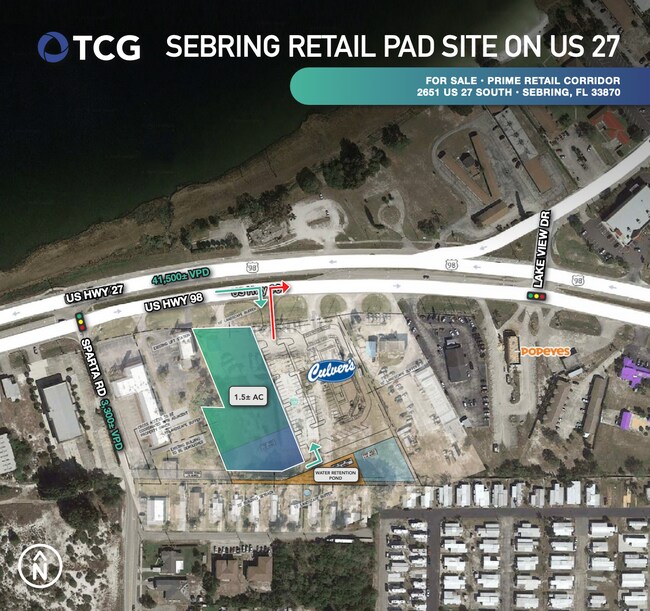
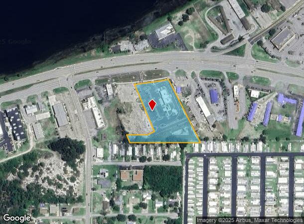
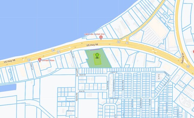
Property Record
2651 Us Highway 27 S, Sebring, FL 33870
NEARBY LISTINGS FOR SALE OR LEASE
Property Detail
2651 Us Highway 27 S
Sebring, FL
Sunset Beach Sub
S-32-34-29-070-0030-0540
S & L PROPERTIES SEBRING PB 17 PG 53 PARCEL 1
Restaurantbuilding
Highlands
X
Florida
12055C0227C
54-56
2024
2.88 AC
2025
Florida Central South Area
961303
Other Market Areas
4,811 SF
DEMOGRAPHICS near 2651 Us Highway 27 S
1 Mile
3 Mile
5 Mile
2024 Total Population
2,885
22,501
41,408
2029 Population
3,169
24,532
45,113
Pop Growth 2024-2029
+ 9.84%
+ 9.03%
+ 8.95%
Average Age
57
48
50
2024 Total Households
1,539
9,911
18,662
HH Growth 2024-2029
+ 10.01%
+ 9.13%
+ 9.11%
Median Household Inc
$29,603
$38,123
$44,292
Avg Household Size
1.80
2.20
2.10
2024 Avg HH Vehicles
1.00
1.00
2.00
Median Home Value
$136,976
$144,393
$145,168
Median Year Built
1981
1981
1984
Nearby Places
Map Layers
Map Styles
 Street
 Aerial
- Restaurants
- Banks
- Shops
- Fitness
- Groceries
PUBLIC TRANSPORTATION
COMMUTER RAIL
DRIVE
WALK
Distance
6 min
2.4 mi
SALE & LEASE HISTORY
LISTING DATE
SALE/LEASE

Sep 06, 2022
For Sale
Nov 07, 2022
For Sale
Nearby Properties
Address
Land Use
TOTAL SIZE
Lot Size
Zoning
Address
Land Use
TOTAL SIZE
Lot Size
Zoning
123,239 SF
10.51 AC
C1
Address
Land Use
TOTAL SIZE
Lot Size
Zoning
224,707 SF
31.63 AC
PU
Address
Land Use
TOTAL SIZE
Lot Size
Zoning
114,905 SF
3.34 AC
PU
Address
Land Use
TOTAL SIZE
Lot Size
Zoning
91,734 SF
2.23 AC
R3
Address
Land Use
TOTAL SIZE
Lot Size
Zoning
114,960 SF
6.68 AC
PU
Address
Land Use
TOTAL SIZE
Lot Size
Zoning
128,672 SF
6.84 AC
C1
Address
Land Use
TOTAL SIZE
Lot Size
Zoning
40,295 SF
1.65 AC
C1
Address
Land Use
TOTAL SIZE
Lot Size
Zoning
58,228 SF
2.64 AC
C1
Address
Land Use
TOTAL SIZE
Lot Size
Zoning
41,224 SF
2.16 AC
C1
Address
Land Use
TOTAL SIZE
Lot Size
Zoning
78,313 SF
18.85 AC
PU
Address
Land Use
TOTAL SIZE
Lot Size
Zoning
78,361 SF
3.12 AC
PU
Address
Land Use
TOTAL SIZE
Lot Size
Zoning
81,888 SF
4.80 AC
C1
Address
Land Use
TOTAL SIZE
Lot Size
Zoning
76,186 SF
6.38 AC
C1
Address
Land Use
TOTAL SIZE
Lot Size
Zoning
57,978 SF
3.80 AC
MUQD
Address
Land Use
TOTAL SIZE
Lot Size
Zoning
73,229 SF
14.19 AC
PU
Address
Land Use
TOTAL SIZE
Lot Size
Zoning
64,124 SF
4.16 AC
PU
Address
Land Use
TOTAL SIZE
Lot Size
Zoning
41,822 SF
4.11 AC
C1
Address
Land Use
TOTAL SIZE
Lot Size
Zoning
82,784 SF
12.22 AC
R3FUD
Address
Land Use
TOTAL SIZE
Lot Size
Zoning
55,072 SF
5.16 AC
MUQD
Address
Land Use
TOTAL SIZE
Lot Size
Zoning
53,075 SF
12.27 AC
R3FUD
Address
Land Use
TOTAL SIZE
Lot Size
Zoning
40,085 SF
9.72 AC
R3FUD
Address
Land Use
TOTAL SIZE
Lot Size
Zoning
31,806 SF
6 AC
R3
Address
Land Use
TOTAL SIZE
Lot Size
Zoning
388,414 SF
49.99 AC
B4FUD
Address
Land Use
TOTAL SIZE
Lot Size
Zoning
53,846 SF
2.03 AC
C1
Address
Land Use
TOTAL SIZE
Lot Size
Zoning
49,298 SF
33.38 AC
PU
Address
Land Use
TOTAL SIZE
Lot Size
Zoning
34,234 SF
3.46 AC
C1
Address
Land Use
TOTAL SIZE
Lot Size
Zoning
40,680 SF
5.29 AC
C1
Address
Land Use
TOTAL SIZE
Lot Size
Zoning
49,983 SF
7.31 AC
MUQD
Address
Land Use
TOTAL SIZE
Lot Size
Zoning
65,640 SF
6.89 AC
MUQD
Address
Land Use
TOTAL SIZE
Lot Size
Zoning
30,282 SF
2.75 AC
MUQD
The World's #1 Commercial Real Estate Marketplace
Connect with us
© 2026 CoStar Group
The information above has been obtained from sources believed reliable. While we do not doubt its accuracy we have not verified it and make no guarantee, warranty or representation about it. It is your responsibility to independently confirm its accuracy and completeness. Any projections, opinions, assumptions, or estimates used are for example only and do not represent the current or future performance of the property. The value of this transaction to you depends on tax and other factors which should be evaluated by your tax, financial, and legal advisors. You and your advisors should conduct a careful, independent investigation of the property to determine to your satisfaction the suitability of the property for your needs.