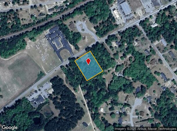
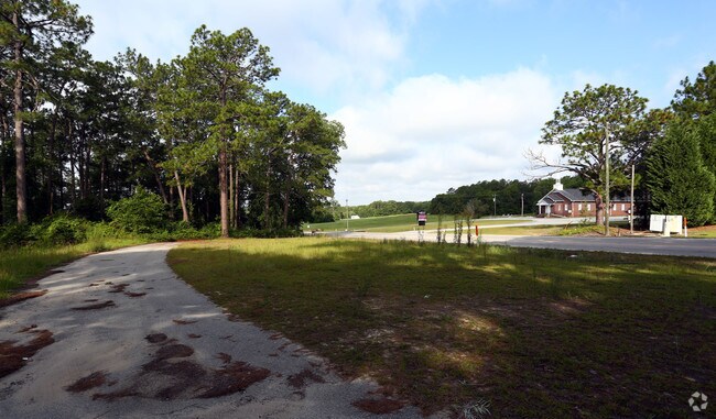
Property Record
2657 Highway 1 S, Elgin, SC 29045

NEARBY LISTINGS FOR SALE OR LEASE
Property Detail
2657 Highway 1 S
E347-00-00-046
896-170 US HWY #1S
Residentialacreage
Kershaw
X
South Carolina
45055C0416F
1.32 AC
2025
Kershaw County
2025
Columbia
970908
Columbia, SC
DEMOGRAPHICS near 2657 Highway 1 S
1 Mile
3 Mile
5 Mile
2024 Total Population
2,377
14,659
45,816
2029 Population
2,608
15,809
47,870
Pop Growth 2024-2029
+ 9.72%
+ 7.85%
+ 4.48%
Average Age
39
38
38
2024 Total Households
865
5,345
16,930
HH Growth 2024-2029
+ 9.71%
+ 7.82%
+ 4.51%
Median Household Inc
$58,480
$66,394
$71,967
Avg Household Size
2.70
2.70
2.70
2024 Avg HH Vehicles
2.00
2.00
2.00
Median Home Value
$171,323
$180,697
$207,879
Median Year Built
1996
2000
2003
Nearby Places
Map Layers
Map Styles
 Street
 Aerial
- Restaurants
- Banks
- Shops
- Fitness
- Groceries
PUBLIC TRANSPORTATION
AIRPORT
Columbia Metro
DRIVE
WALK
Distance
Columbia Metro
51 min
30.2 mi
Freight Ports
North Charleston Terminal
DRIVE
WALK
Distance
North Charleston Terminal
147 min
125.9 mi
SALE & LEASE HISTORY
LISTING DATE
SALE/LEASE

Sep 24, 2016
For Sale
Jul 25, 2017
For Sale
Nearby Properties
Address
Land Use
TOTAL SIZE
Lot Size
Zoning
Address
Land Use
TOTAL SIZE
Lot Size
Zoning
2,420 SF
4.03 AC
M-1
Address
Land Use
TOTAL SIZE
Lot Size
Zoning
84,840 SF
5.19 AC
B2
Address
Land Use
TOTAL SIZE
Lot Size
Zoning
40,603 SF
4.64 AC
MUNICIPAL
Address
Land Use
TOTAL SIZE
Lot Size
Zoning
41,886 SF
4.56 AC
MUNICIPAL
Address
Land Use
TOTAL SIZE
Lot Size
Zoning
9,397 SF
5.50 AC
OI
Address
Land Use
TOTAL SIZE
Lot Size
Zoning
2,583 SF
1.24 AC
MUNICIPAL
Address
Land Use
TOTAL SIZE
Lot Size
Zoning
14,550 SF
2.02 AC
MUNICIPAL
Address
Land Use
TOTAL SIZE
Lot Size
Zoning
63.97 AC
R15
Address
Land Use
TOTAL SIZE
Lot Size
Zoning
7,366 SF
0.52 AC
MUNICIPAL
Address
Land Use
TOTAL SIZE
Lot Size
Zoning
3,542 SF
13.62 AC
PD
Address
Land Use
TOTAL SIZE
Lot Size
Zoning
2,651 SF
0.95 AC
MUNICIPAL
Address
Land Use
TOTAL SIZE
Lot Size
Zoning
9,020 SF
0.83 AC
MUNICIPAL
Address
Land Use
TOTAL SIZE
Lot Size
Zoning
1,620 SF
15.25 AC
RD2
Address
Land Use
TOTAL SIZE
Lot Size
Zoning
6,650 SF
1.19 AC
MUNICIPAL
Address
Land Use
TOTAL SIZE
Lot Size
Zoning
3,512 SF
0.83 AC
MUNICIPAL
Address
Land Use
TOTAL SIZE
Lot Size
Zoning
4,680 SF
7.54 AC
I1
Address
Land Use
TOTAL SIZE
Lot Size
Zoning
4.06 AC
MUNICIPAL
Address
Land Use
TOTAL SIZE
Lot Size
Zoning
10,200 SF
1.54 AC
MUNICIPAL
Address
Land Use
TOTAL SIZE
Lot Size
Zoning
4.20 AC
MUNICIPAL
Address
Land Use
TOTAL SIZE
Lot Size
Zoning
3,810 SF
7.50 AC
R15
Address
Land Use
TOTAL SIZE
Lot Size
Zoning
14.84 AC
GD
Address
Land Use
TOTAL SIZE
Lot Size
Zoning
3,120 SF
0.92 AC
MUNICIPAL
Address
Land Use
TOTAL SIZE
Lot Size
Zoning
13,500 SF
1.06 AC
GD
Address
Land Use
TOTAL SIZE
Lot Size
Zoning
11,500 SF
1.11 AC
MUNICIPAL
Address
Land Use
TOTAL SIZE
Lot Size
Zoning
7,722 SF
0.68 AC
Address
Land Use
TOTAL SIZE
Lot Size
Zoning
13,680 SF
2.96 AC
B2
Address
Land Use
TOTAL SIZE
Lot Size
Zoning
10,100 SF
2.50 AC
B2
Address
Land Use
TOTAL SIZE
Lot Size
Zoning
6,000 SF
0.79 AC
GC
Address
Land Use
TOTAL SIZE
Lot Size
Zoning
2,400 SF
0.64 AC
MUNICIPAL
Address
Land Use
TOTAL SIZE
Lot Size
Zoning
9.80 AC
R15
The World's #1 Commercial Real Estate Marketplace
Connect with us
© 2025 CoStar Group
The information above has been obtained from sources believed reliable. While we do not doubt its accuracy we have not verified it and make no guarantee, warranty or representation about it. It is your responsibility to independently confirm its accuracy and completeness. Any projections, opinions, assumptions, or estimates used are for example only and do not represent the current or future performance of the property. The value of this transaction to you depends on tax and other factors which should be evaluated by your tax, financial, and legal advisors. You and your advisors should conduct a careful, independent investigation of the property to determine to your satisfaction the suitability of the property for your needs.