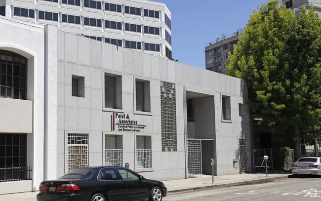
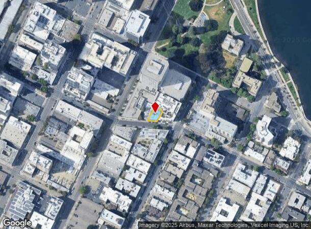
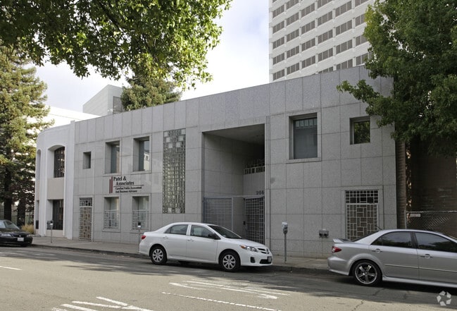
Property Record
266 17Th St, Oakland, CA 94612

NEARBY LISTINGS FOR SALE OR LEASE
Property Detail
266 17Th St
Oakland-Hayward-Berkeley, CA
Alice Park Prop
008-0626-006-02
PORTION LOT15
Officebuilding
Alameda
X
California
06001C0067H
15
2024
0.10 AC
2025
Oakland-Downtown
402900
East Bay/Oakland
8,478 SF
DEMOGRAPHICS near 266 17Th St
1 Mile
3 Mile
5 Mile
2024 Total Population
60,323
278,693
511,441
2029 Population
59,497
271,694
497,058
Pop Growth 2024-2029
(1.37%)
(2.51%)
(2.81%)
Average Age
43
41
40
2024 Total Households
31,392
118,409
205,224
HH Growth 2024-2029
(1.42%)
(2.55%)
(2.87%)
Median Household Inc
$80,743
$92,842
$95,010
Avg Household Size
1.80
2.20
2.30
2024 Avg HH Vehicles
1.00
1.00
1.00
Median Home Value
$792,911
$1,011,824
$1,026,891
Median Year Built
1971
1956
1955
Nearby Places
Map Layers
Map Styles
 Street
 Aerial
- Restaurants
- Banks
- Shops
- Fitness
- Groceries
PUBLIC TRANSPORTATION
TRANSIT/SUBWAY
19Th St Oakland Station (Antioch to SFIA/Millbrae - Bay Area Rapid Transit (BART), Berryessa/North San Jose to Richmond - Bay Area Rapid Transit (BART), Fremont - Richmond - Bay Area Rapid Transit (BART), Millbrae/SFIA to Antioch - Bay Area Rapid Transit (BART), Millbrae/SFO to Richmond - Bay Area Rapid Transit (BART), Pittsburg/Bay Point - San Francisco International - Bay Area Rapid Transit (BART), Richmond - Millbrae - Bay Area Rapid Transit (BART), Richmond to SFO/Millbrae - Bay Area Rapid Transit (BART))
DRIVE
WALK
Distance
19Th St Oakland Station (Antioch to SFIA/Millbrae - Bay Area Rapid Transit (BART), Berryessa/North San Jose to Richmond - Bay Area Rapid Transit (BART), Fremont - Richmond - Bay Area Rapid Transit (BART), Millbrae/SFIA to Antioch - Bay Area Rapid Transit (BART), Millbrae/SFO to Richmond - Bay Area Rapid Transit (BART), Pittsburg/Bay Point - San Francisco International - Bay Area Rapid Transit (BART), Richmond - Millbrae - Bay Area Rapid Transit (BART), Richmond to SFO/Millbrae - Bay Area Rapid Transit (BART))
2 min
7 min
0.4 mi
12Th Street / Oakland City Center (Antioch to SFIA/Millbrae - Bay Area Rapid Transit (BART), Berryessa/North San Jose to Richmond - Bay Area Rapid Transit (BART), Millbrae/SFIA to Antioch - Bay Area Rapid Transit (BART), Millbrae/SFO to Richmond - Bay Area Rapid Transit (BART), Richmond to SFO/Millbrae - Bay Area Rapid Transit (BART))
DRIVE
WALK
Distance
12Th Street / Oakland City Center (Antioch to SFIA/Millbrae - Bay Area Rapid Transit (BART), Berryessa/North San Jose to Richmond - Bay Area Rapid Transit (BART), Millbrae/SFIA to Antioch - Bay Area Rapid Transit (BART), Millbrae/SFO to Richmond - Bay Area Rapid Transit (BART), Richmond to SFO/Millbrae - Bay Area Rapid Transit (BART))
2 min
9 min
0.5 mi
12Th St Oakland City Center Station (Fremont - Richmond - Bay Area Rapid Transit (BART), Pittsburg/Bay Point - San Francisco International - Bay Area Rapid Transit (BART), Richmond - Millbrae - Bay Area Rapid Transit (BART))
DRIVE
WALK
Distance
12Th St Oakland City Center Station (Fremont - Richmond - Bay Area Rapid Transit (BART), Pittsburg/Bay Point - San Francisco International - Bay Area Rapid Transit (BART), Richmond - Millbrae - Bay Area Rapid Transit (BART))
2 min
10 min
0.5 mi
Lake Merritt Station (Dublin/Pleasanton - Millbrae - Bay Area Rapid Transit (BART), Fremont - Daly City - Bay Area Rapid Transit (BART), Fremont - Richmond - Bay Area Rapid Transit (BART))
DRIVE
WALK
Distance
Lake Merritt Station (Dublin/Pleasanton - Millbrae - Bay Area Rapid Transit (BART), Fremont - Daly City - Bay Area Rapid Transit (BART), Fremont - Richmond - Bay Area Rapid Transit (BART))
2 min
14 min
0.7 mi
COMMUTER RAIL
Oakland (Capitol Corridor - Amtrak, Coast Starlight - Amtrak, San Joaquins - Amtrak)
DRIVE
WALK
Distance
Oakland (Capitol Corridor - Amtrak, Coast Starlight - Amtrak, San Joaquins - Amtrak)
3 min
19 min
1.0 mi
Emeryville (California Zephyr - Amtrak, Capitol Corridor - Amtrak, Coast Starlight - Amtrak, San Joaquins - Amtrak)
DRIVE
WALK
Distance
Emeryville (California Zephyr - Amtrak, Capitol Corridor - Amtrak, Coast Starlight - Amtrak, San Joaquins - Amtrak)
9 min
4.9 mi
AIRPORT
Metro Oakland International
DRIVE
WALK
Distance
Metro Oakland International
15 min
9.3 mi
San Francisco International
DRIVE
WALK
Distance
San Francisco International
37 min
22.7 mi
Freight Ports
Port of Oakland
DRIVE
WALK
Distance
Port of Oakland
4 min
1.7 mi
SALE & LEASE HISTORY
LISTING DATE
SALE/LEASE

Jun 29, 2017
For Lease
Feb 12, 2018
For Lease
Apr 11, 2018
For Sale
Nearby Properties
Address
Land Use
TOTAL SIZE
Lot Size
Zoning
Address
Land Use
TOTAL SIZE
Lot Size
Zoning
409,266 SF
1.76 AC
Address
Land Use
TOTAL SIZE
Lot Size
Zoning
1,028,501 SF
2.74 AC
Address
Land Use
TOTAL SIZE
Lot Size
Zoning
652,524 SF
1.38 AC
Address
Land Use
TOTAL SIZE
Lot Size
Zoning
617,980 SF
1.08 AC
Address
Land Use
TOTAL SIZE
Lot Size
Zoning
568,722 SF
0.99 AC
Address
Land Use
TOTAL SIZE
Lot Size
Zoning
767,791 SF
1.38 AC
Address
Land Use
TOTAL SIZE
Lot Size
Zoning
373,594 SF
16.16 AC
Address
Land Use
TOTAL SIZE
Lot Size
Zoning
488,781 SF
0.63 AC
Address
Land Use
TOTAL SIZE
Lot Size
Zoning
490,000 SF
1.44 AC
Address
Land Use
TOTAL SIZE
Lot Size
Zoning
432,352 SF
Address
Land Use
TOTAL SIZE
Lot Size
Zoning
525,866 SF
1.38 AC
Address
Land Use
TOTAL SIZE
Lot Size
Zoning
354,263 SF
4.06 AC
Address
Land Use
TOTAL SIZE
Lot Size
Zoning
546,164 SF
6.02 AC
Address
Land Use
TOTAL SIZE
Lot Size
Zoning
328,427 SF
0.52 AC
Address
Land Use
TOTAL SIZE
Lot Size
Zoning
423,577 SF
1.04 AC
Address
Land Use
TOTAL SIZE
Lot Size
Zoning
405,462 SF
11.67 AC
Address
Land Use
TOTAL SIZE
Lot Size
Zoning
621,432 SF
1.31 AC
C
Address
Land Use
TOTAL SIZE
Lot Size
Zoning
288,796 SF
0.52 AC
Address
Land Use
TOTAL SIZE
Lot Size
Zoning
371,504 SF
4.08 AC
Address
Land Use
TOTAL SIZE
Lot Size
Zoning
788,983 SF
1.63 AC
Address
Land Use
TOTAL SIZE
Lot Size
Zoning
0.73 AC
Address
Land Use
TOTAL SIZE
Lot Size
Zoning
703,758 SF
3.44 AC
Address
Land Use
TOTAL SIZE
Lot Size
Zoning
371,322 SF
1.62 AC
Address
Land Use
TOTAL SIZE
Lot Size
Zoning
240,633 SF
1.59 AC
Address
Land Use
TOTAL SIZE
Lot Size
Zoning
350,741 SF
1.08 AC
Address
Land Use
TOTAL SIZE
Lot Size
Zoning
344,273 SF
0.51 AC
Address
Land Use
TOTAL SIZE
Lot Size
Zoning
273,623 SF
1.44 AC
Address
Land Use
TOTAL SIZE
Lot Size
Zoning
245,717 SF
0.65 AC
Address
Land Use
TOTAL SIZE
Lot Size
Zoning
303,063 SF
1.27 AC
Address
Land Use
TOTAL SIZE
Lot Size
Zoning
297,617 SF
1.54 AC
The World's #1 Commercial Real Estate Marketplace
Connect with us
© 2025 CoStar Group
The information above has been obtained from sources believed reliable. While we do not doubt its accuracy we have not verified it and make no guarantee, warranty or representation about it. It is your responsibility to independently confirm its accuracy and completeness. Any projections, opinions, assumptions, or estimates used are for example only and do not represent the current or future performance of the property. The value of this transaction to you depends on tax and other factors which should be evaluated by your tax, financial, and legal advisors. You and your advisors should conduct a careful, independent investigation of the property to determine to your satisfaction the suitability of the property for your needs.