Property Record
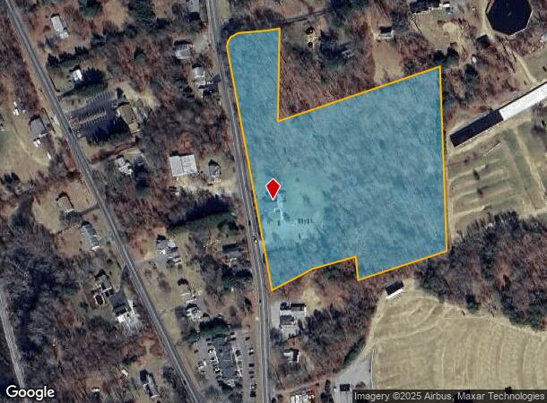
266 Stafford Rd, Mansfield Center, CT 06250

NEARBY LISTINGS FOR SALE OR LEASE
Property Detail
266 Stafford Rd
Hartford-West Hartford-East Hartford, CT
Tolland
MANS-000031-000088-000010
Connecticut
Commercialbuilding
10
2025
8.94 AC
2025
Tolland County
881500
Hartford
1,942 SF
DEMOGRAPHICS near 266 Stafford Rd
1 Mile
3 Mile
5 Mile
2024 Total Population
1,081
16,324
55,826
2029 Population
1,066
16,450
55,755
Pop Growth 2024-2029
(1.39%)
+ 0.77%
(0.13%)
Average Age
43
37
35
2024 Total Households
417
5,590
16,732
HH Growth 2024-2029
(1.44%)
+ 0.70%
(0.19%)
Median Household Inc
$81,127
$47,057
$53,037
Avg Household Size
2.60
2.40
2.30
2024 Avg HH Vehicles
2.00
2.00
2.00
Median Home Value
$256,818
$235,805
$239,345
Median Year Built
1955
1968
1968
Nearby Places
Map Layers
Map Styles
 Street
 Aerial
- Restaurants
- Banks
- Shops
- Fitness
- Groceries
PUBLIC TRANSPORTATION
AIRPORT
Bradley International
DRIVE
WALK
Distance
Bradley International
64 min
40.7 mi
Freight Ports
Port of Davisville, RI
DRIVE
WALK
Distance
Port of Davisville, RI
86 min
63.9 mi
Nearby Properties
Address
Land Use
TOTAL SIZE
Lot Size
Zoning
Address
Land Use
TOTAL SIZE
Lot Size
Zoning
14.62 AC
B4
Address
Land Use
TOTAL SIZE
Lot Size
Zoning
33,366 SF
R6
Address
Land Use
TOTAL SIZE
Lot Size
Zoning
145,144 SF
R6
Address
Land Use
TOTAL SIZE
Lot Size
Zoning
111,757 SF
6.74 AC
RL
Address
Land Use
TOTAL SIZE
Lot Size
Zoning
90,450 SF
R6
Address
Land Use
TOTAL SIZE
Lot Size
Zoning
99,139 SF
R6
Address
Land Use
TOTAL SIZE
Lot Size
Zoning
316,812 SF
39.88 AC
R4
Address
Land Use
TOTAL SIZE
Lot Size
Zoning
57,648 SF
R6
Address
Land Use
TOTAL SIZE
Lot Size
Zoning
28,231 SF
R6
Address
Land Use
TOTAL SIZE
Lot Size
Zoning
93.53 AC
RAR90
Address
Land Use
TOTAL SIZE
Lot Size
Zoning
158,766 SF
3.91 AC
R6
Address
Land Use
TOTAL SIZE
Lot Size
Zoning
24,313 SF
R6
Address
Land Use
TOTAL SIZE
Lot Size
Zoning
63,224 SF
2.68 AC
R6
Address
Land Use
TOTAL SIZE
Lot Size
Zoning
44,000 SF
R6
Address
Land Use
TOTAL SIZE
Lot Size
Zoning
1,552 SF
10.06 AC
DMR
Address
Land Use
TOTAL SIZE
Lot Size
Zoning
3.50 AC
R6
Address
Land Use
TOTAL SIZE
Lot Size
Zoning
174 SF
R5
Address
Land Use
TOTAL SIZE
Lot Size
Zoning
14.12 AC
B2A
Address
Land Use
TOTAL SIZE
Lot Size
Zoning
58,264 SF
5.97 AC
B2A
Address
Land Use
TOTAL SIZE
Lot Size
Zoning
142 AC
R5 - 1
Address
Land Use
TOTAL SIZE
Lot Size
Zoning
40,897 SF
0.62 AC
R6
Address
Land Use
TOTAL SIZE
Lot Size
Zoning
13,452 SF
4 AC
DMR
Address
Land Use
TOTAL SIZE
Lot Size
Zoning
71,976 SF
3.15 AC
R6
Address
Land Use
TOTAL SIZE
Lot Size
Zoning
223,296 SF
R6
Address
Land Use
TOTAL SIZE
Lot Size
Zoning
53.16 AC
M4
Address
Land Use
TOTAL SIZE
Lot Size
Zoning
22.70 AC
RAR90
Address
Land Use
TOTAL SIZE
Lot Size
Zoning
36,560 SF
R6
Address
Land Use
TOTAL SIZE
Lot Size
Zoning
14.59 AC
R5
Address
Land Use
TOTAL SIZE
Lot Size
Zoning
19,975 SF
R6
Address
Land Use
TOTAL SIZE
Lot Size
Zoning
34,918 SF
R6
The World's #1 Commercial Real Estate Marketplace
Connect with us
© 2025 CoStar Group
The information above has been obtained from sources believed reliable. While we do not doubt its accuracy we have not verified it and make no guarantee, warranty or representation about it. It is your responsibility to independently confirm its accuracy and completeness. Any projections, opinions, assumptions, or estimates used are for example only and do not represent the current or future performance of the property. The value of this transaction to you depends on tax and other factors which should be evaluated by your tax, financial, and legal advisors. You and your advisors should conduct a careful, independent investigation of the property to determine to your satisfaction the suitability of the property for your needs.