Property Record
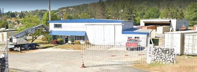
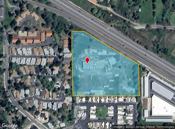
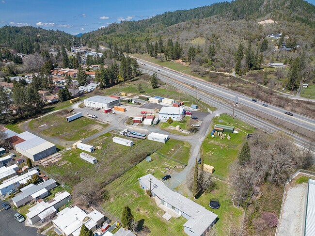
2660 Nw Vine St, Grants Pass, OR 97526
Property Detail
2660 Nw Vine St
R306789
ACRES 7.80
Industrialgeneral
Josephine
X
Oregon
41033C0504E
100
2024
7.80 AC
2025
Medford/Grants Pass
360602
Other Market Areas
1,840 SF
Grants Pass, OR
NEARBY LISTINGS FOR SALE OR LEASE
DEMOGRAPHICS near 2660 Nw Vine St
1 mile
3 mile
5 mile
2024 Total Population
3,351
25,600
52,041
2029 Population
3,324
25,539
52,105
Pop Growth 2024-2029
(0.81%)
(0.24%)
+ 0.12%
Average Age
47
43
44
2024 Total Households
1,267
10,408
21,228
HH Growth 2024-2029
(1.03%)
(0.28%)
+ 0.11%
Median Household Inc
$76,532
$45,411
$47,483
Avg Household Size
2.40
2.30
2.40
2024 Avg HH Vehicles
2.00
2.00
2.00
Median Home Value
$387,296
$337,152
$353,158
Median Year Built
1984
1975
1981
Nearby Places
Map Layers
Map Styles
 Street
 Aerial
Transit
 Traffic
 Biking
Places
Listings with unknown addresses are not visible on the map
- Restaurants
- Banks
- Shops
- Fitness
- Groceries
PUBLIC TRANSPORTATION
AIRPORT
Rogue Valley International - Medford
Drive
Walk
Distance
Rogue Valley International - Medford
38 min
28.9 mi
Freight Ports
Port of Coos Bay, OR
Drive
Walk
Distance
Port of Coos Bay, OR
184 min
134.6 mi
SALE & LEASE HISTORY
LISTING DATE
SALE/LEASE

May 09, 2023
For Sale
Jan 25, 2022
For Sale
Feb 05, 2024
For Sale
Nearby Properties
Address
Land Use
TOTAL SIZE
Lot Size
Zoning
Address
Land Use
TOTAL SIZE
Lot Size
Zoning
1,324,134 SF
9.03 AC
R-1-6
Address
Land Use
TOTAL SIZE
Lot Size
Zoning
49,752 SF
11.21 AC
R-2
Address
Land Use
TOTAL SIZE
Lot Size
Zoning
13,764 SF
3.32 AC
R-2
Address
Land Use
TOTAL SIZE
Lot Size
Zoning
11.54 AC
I
Address
Land Use
TOTAL SIZE
Lot Size
Zoning
360 SF
18.68 AC
I
Address
Land Use
TOTAL SIZE
Lot Size
Zoning
4,888 SF
2.58 AC
R-4,GC
Address
Land Use
TOTAL SIZE
Lot Size
Zoning
8,706 SF
13.73 AC
GC
Address
Land Use
TOTAL SIZE
Lot Size
Zoning
7.31 AC
MP
Address
Land Use
TOTAL SIZE
Lot Size
Zoning
Address
Land Use
TOTAL SIZE
Lot Size
Zoning
59,342 SF
4.14 AC
BP
Address
Land Use
TOTAL SIZE
Lot Size
Zoning
47,766 SF
2.02 AC
GC
Address
Land Use
TOTAL SIZE
Lot Size
Zoning
9.70 AC
BP
Address
Land Use
TOTAL SIZE
Lot Size
Zoning
8.48 AC
BP
Address
Land Use
TOTAL SIZE
Lot Size
Zoning
4,568 SF
5.71 AC
R-2
Address
Land Use
TOTAL SIZE
Lot Size
Zoning
34,446 SF
2.62 AC
IP
Address
Land Use
TOTAL SIZE
Lot Size
Zoning
66,148 SF
2.63 AC
I
Address
Land Use
TOTAL SIZE
Lot Size
Zoning
47,060 SF
10.65 AC
R-1-6
Address
Land Use
TOTAL SIZE
Lot Size
Zoning
142,166 SF
12.41 AC
I
Address
Land Use
TOTAL SIZE
Lot Size
Zoning
9.70 AC
BP
Address
Land Use
TOTAL SIZE
Lot Size
Zoning
26,000 SF
9.12 AC
R-1-8
Address
Land Use
TOTAL SIZE
Lot Size
Zoning
1,222 SF
22.68 AC
R-1-8
Address
Land Use
TOTAL SIZE
Lot Size
Zoning
115,852 SF
8.79 AC
GC
Address
Land Use
TOTAL SIZE
Lot Size
Zoning
17,350 SF
6.63 AC
BP
Address
Land Use
TOTAL SIZE
Lot Size
Zoning
2,450 SF
10.02 AC
CLI
Address
Land Use
TOTAL SIZE
Lot Size
Zoning
26,079 SF
6.32 AC
GC
Address
Land Use
TOTAL SIZE
Lot Size
Zoning
50,375 SF
4.79 AC
R-3
Address
Land Use
TOTAL SIZE
Lot Size
Zoning
8.48 AC
BP
Address
Land Use
TOTAL SIZE
Lot Size
Zoning
61,881 SF
7.49 AC
GC
Address
Land Use
TOTAL SIZE
Lot Size
Zoning
74,976 SF
2.06 AC
R-4
Address
Land Use
TOTAL SIZE
Lot Size
Zoning
68,052 SF
9.25 AC
GC
The World's #1 Commercial Real Estate Marketplace
Connect with us
© 2026 CoStar Group
The information above has been obtained from sources believed reliable. While we do not doubt its accuracy we have not verified it and make no guarantee, warranty or representation about it. It is your responsibility to independently confirm its accuracy and completeness. Any projections, opinions, assumptions, or estimates used are for example only and do not represent the current or future performance of the property. The value of this transaction to you depends on tax and other factors which should be evaluated by your tax, financial, and legal advisors. You and your advisors should conduct a careful, independent investigation of the property to determine to your satisfaction the suitability of the property for your needs.