Property Record
2660 State Route 9L Rd, Queensbury, NY 12804
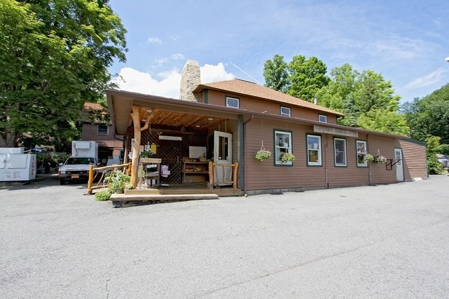
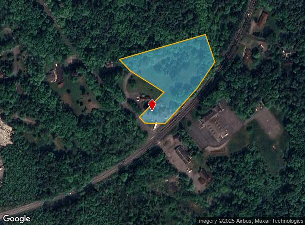

This Property Is For Sale
NEARBY LISTINGS FOR SALE OR LEASE
-
-
View all Queensbury listings for sale on LoopNet.com
Property Detail
2660 State Route 9L Rd
Glens Falls, NY
Warren
523400 240.9-1-8.1
New York
Servicestationmarket
8.001
2025
3.14 AC
2024
Warren County
070701
Albany/Schenectady/Troy
3,472 SF
DEMOGRAPHICS near 2660 State Route 9L Rd
1 Mile
3 Mile
5 Mile
2024 Total Population
336
2,057
7,189
2029 Population
341
2,120
7,327
Pop Growth 2024-2029
+ 1.49%
+ 3.06%
+ 1.92%
Average Age
55
51
48
2024 Total Households
164
904
3,206
HH Growth 2024-2029
+ 1.22%
+ 2.99%
+ 1.78%
Median Household Inc
$128,532
$108,433
$93,309
Avg Household Size
2.00
2.20
2.20
2024 Avg HH Vehicles
2.00
2.00
2.00
Median Home Value
$462,499
$377,961
$339,731
Median Year Built
1956
1970
1972
Nearby Places
- Restaurants
- Banks
- Shops
- Fitness
- Groceries
Nearby Properties
Address
Land Use
TOTAL SIZE
Lot Size
Zoning
Address
Land Use
TOTAL SIZE
Lot Size
Zoning
Address
Land Use
TOTAL SIZE
Lot Size
Zoning
2,250 SF
36.02 AC
07 - MIXED
Address
Land Use
TOTAL SIZE
Lot Size
Zoning
5,170 SF
8.74 AC
07
Address
Land Use
TOTAL SIZE
Lot Size
Zoning
11,579 SF
3.30 AC
07 - MIXED
Address
Land Use
TOTAL SIZE
Lot Size
Zoning
442 SF
1.02 AC
WR
Address
Land Use
TOTAL SIZE
Lot Size
Zoning
4,036 SF
1.30 AC
07 - MIXED
Address
Land Use
TOTAL SIZE
Lot Size
Zoning
1,083 SF
1.10 AC
WR
Address
Land Use
TOTAL SIZE
Lot Size
Zoning
16.14 AC
WR
Address
Land Use
TOTAL SIZE
Lot Size
Zoning
3,916 SF
0.63 AC
01 - NOT Z
Address
Land Use
TOTAL SIZE
Lot Size
Zoning
6,960 SF
3.99 AC
WR
Address
Land Use
TOTAL SIZE
Lot Size
Zoning
3,416 SF
1.14 AC
WR
Address
Land Use
TOTAL SIZE
Lot Size
Zoning
3,700 SF
1.40 AC
WR
Address
Land Use
TOTAL SIZE
Lot Size
Zoning
2,988 SF
0.89 AC
WR
Address
Land Use
TOTAL SIZE
Lot Size
Zoning
2,506 SF
1.06 AC
WR
Address
Land Use
TOTAL SIZE
Lot Size
Zoning
4,174 SF
1.73 AC
07 - MIXED
Address
Land Use
TOTAL SIZE
Lot Size
Zoning
Address
Land Use
TOTAL SIZE
Lot Size
Zoning
3,906 SF
1.19 AC
07 - MIXED
Address
Land Use
TOTAL SIZE
Lot Size
Zoning
3,140 SF
0.39 AC
WR
Address
Land Use
TOTAL SIZE
Lot Size
Zoning
11.32 AC
07 - MIXED
Address
Land Use
TOTAL SIZE
Lot Size
Zoning
7,973 SF
1.29 AC
05 - COMME
Address
Land Use
TOTAL SIZE
Lot Size
Zoning
2,597 SF
2.98 AC
02 - SINGL
Address
Land Use
TOTAL SIZE
Lot Size
Zoning
3,793 SF
1.17 AC
07 - MIXED
Address
Land Use
TOTAL SIZE
Lot Size
Zoning
2,947 SF
0.71 AC
WR
Address
Land Use
TOTAL SIZE
Lot Size
Zoning
5,475 SF
6.81 AC
WR
Address
Land Use
TOTAL SIZE
Lot Size
Zoning
0.69 AC
WR
Address
Land Use
TOTAL SIZE
Lot Size
Zoning
14,316 SF
0.61 AC
WR
Address
Land Use
TOTAL SIZE
Lot Size
Zoning
1,490 SF
1.15 AC
WR
Address
Land Use
TOTAL SIZE
Lot Size
Zoning
13,278 SF
27.81 AC
LC-42A
Address
Land Use
TOTAL SIZE
Lot Size
Zoning
Address
Land Use
TOTAL SIZE
Lot Size
Zoning
1,814 SF
0.59 AC
WR
The World's #1 Commercial Real Estate Marketplace
Connect with us
© 2025 CoStar Group
The information above has been obtained from sources believed reliable. While we do not doubt its accuracy we have not verified it and make no guarantee, warranty or representation about it. It is your responsibility to independently confirm its accuracy and completeness. Any projections, opinions, assumptions, or estimates used are for example only and do not represent the current or future performance of the property. The value of this transaction to you depends on tax and other factors which should be evaluated by your tax, financial, and legal advisors. You and your advisors should conduct a careful, independent investigation of the property to determine to your satisfaction the suitability of the property for your needs.