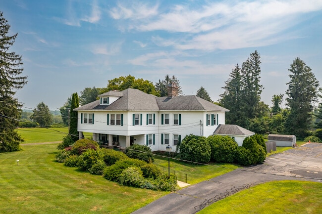
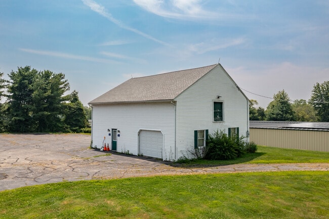
Property Record
2665 Boston Tpke, Coventry, CT 06238

Save to a Folder
{{folder.Name}}
{{folder.ListingIds.length}} Properties
{{folder.ListingIds.length}} Property
Create a New Folder
Property Detail
2665 Boston Tpke
Hartford-West Hartford-East Hartford, CT
TOLLAND
COVE-000008-000004-A000000-000007
Connecticut
Commercialnec
28
C
1.92 AC
2025
Tolland County
2025
Hartford
850100
NEARBY LISTINGS FOR SALE OR LEASE
-
-
View all Coventry listings for sale on LoopNet.com
DEMOGRAPHICS near 2665 Boston Tpke
1 mile
3 mile
5 mile
2025 Total Population
1,286
9,001
43,803
2030 Population
1,308
9,165
44,676
Pop Growth 2025-2030
+ 1.71%
+ 1.82%
+ 1.99%
Average Age
43
44
43
2025 Total Households
512
3,557
17,997
HH Growth 2025-2030
+ 1.56%
+ 1.83%
+ 2.04%
Median Household Inc
$118,367
$129,605
$111,444
Avg Household Size
2.50
2.50
2.40
2025 Avg HH Vehicles
2.00
2.00
2.00
Median Home Value
$367,484
$367,199
$325,392
Median Year Built
1970
1970
1969
Nearby Places
Map Layers
Map Styles
 Street
 Aerial
Layers
 Traffic
 Biking
Places
Listings with unknown addresses are not visible on the map
- Restaurants
- Banks
- Shops
- Fitness
- Groceries
PUBLIC TRANSPORTATION
AIRPORT
Bradley International
Drive
Walk
Distance
Bradley International
41 min
27.7 mi
Freight Ports
Port of New Haven
Drive
Walk
Distance
Port of New Haven
68 min
52.1 mi
SALE & LEASE HISTORY
LISTING DATE
SALE/LEASE

Jul 29, 2025
For Sale
Nearby Properties
Address
Land Use
TOTAL SIZE
Lot Size
Zoning
Address
Land Use
TOTAL SIZE
Lot Size
Zoning
193 AC
R-40
Address
Land Use
TOTAL SIZE
Lot Size
Zoning
78,559 SF
25.70 AC
R-1
Address
Land Use
TOTAL SIZE
Lot Size
Zoning
49,572 SF
54.92 AC
R-1
Address
Land Use
TOTAL SIZE
Lot Size
Zoning
45,704 SF
9.29 AC
GR80
Address
Land Use
TOTAL SIZE
Lot Size
Zoning
270.50 AC
R-40
Address
Land Use
TOTAL SIZE
Lot Size
Zoning
10.23 AC
C
Address
Land Use
TOTAL SIZE
Lot Size
Zoning
6.99 AC
GMUIZ
Address
Land Use
TOTAL SIZE
Lot Size
Zoning
14,844 SF
5.01 AC
C
Address
Land Use
TOTAL SIZE
Lot Size
Zoning
29,413 SF
22.78 AC
C
Address
Land Use
TOTAL SIZE
Lot Size
Zoning
57.60 AC
R-40
Address
Land Use
TOTAL SIZE
Lot Size
Zoning
9.33 AC
C/A
Address
Land Use
TOTAL SIZE
Lot Size
Zoning
13.92 AC
R-1
Address
Land Use
TOTAL SIZE
Lot Size
Zoning
4,381 SF
2.53 AC
C
Address
Land Use
TOTAL SIZE
Lot Size
Zoning
8.58 AC
R-1
Address
Land Use
TOTAL SIZE
Lot Size
Zoning
8,023 SF
1.12 AC
C
Address
Land Use
TOTAL SIZE
Lot Size
Zoning
9 AC
R-2
Address
Land Use
TOTAL SIZE
Lot Size
Zoning
34,435 SF
2 AC
GB
Address
Land Use
TOTAL SIZE
Lot Size
Zoning
10,938 SF
1.11 AC
GR40
Address
Land Use
TOTAL SIZE
Lot Size
Zoning
112.67 AC
GR80
Address
Land Use
TOTAL SIZE
Lot Size
Zoning
3.90 AC
Address
Land Use
TOTAL SIZE
Lot Size
Zoning
20,000 SF
33.04 AC
GB
Address
Land Use
TOTAL SIZE
Lot Size
Zoning
9 AC
R-2
Address
Land Use
TOTAL SIZE
Lot Size
Zoning
6,650 SF
1.12 AC
C
Address
Land Use
TOTAL SIZE
Lot Size
Zoning
61.42 AC
OPEN S
Address
Land Use
TOTAL SIZE
Lot Size
Zoning
1.94 AC
GR40
Address
Land Use
TOTAL SIZE
Lot Size
Zoning
8,968 SF
1.43 AC
R-1
Address
Land Use
TOTAL SIZE
Lot Size
Zoning
10,716 SF
1.85 AC
GB
Address
Land Use
TOTAL SIZE
Lot Size
Zoning
4,960 SF
16 AC
I
Address
Land Use
TOTAL SIZE
Lot Size
Zoning
8.60 AC
R-27
Address
Land Use
TOTAL SIZE
Lot Size
Zoning
58.46 AC
OPEN S
The World's #1 Commercial Real Estate Marketplace
Connect with us
© 2026 CoStar Group
The information above has been obtained from sources believed reliable. While we do not doubt its accuracy we have not verified it and make no guarantee, warranty or representation about it. It is your responsibility to independently confirm its accuracy and completeness. Any projections, opinions, assumptions, or estimates used are for example only and do not represent the current or future performance of the property. The value of this transaction to you depends on tax and other factors which should be evaluated by your tax, financial, and legal advisors. You and your advisors should conduct a careful, independent investigation of the property to determine to your satisfaction the suitability of the property for your needs.