Property Record
2600 Monroe Rd, De Pere, WI 54115
NEARBY LISTINGS FOR SALE OR LEASE
Property Detail
2600 Monroe Rd
Green Bay, WI
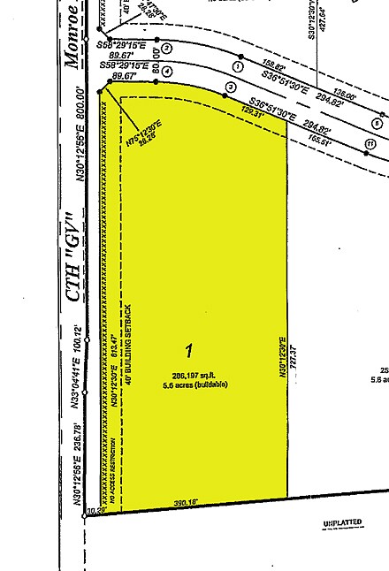
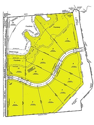
Cert Surv Map 8723
B-315
77.421 AC M/L PRT PC 42E COM NW COR S30*W 33.50 CHAINS,TH S64*E 26.40 CHAINS, TH N26*E 33.50 CHAINS, TH N64*W TO BEG EX HWY & EX 76J2-7; ALSO DESC IN 2198865 & EX RD IN 2443787 & PRT IN 2678822 & EX 62 CSM 75
Agriculturalland
Brown
AE
Wisconsin
55009C0278F
1,2
2024
77.42 AC
2024
Bellevue/De Pere
020704
Green Bay
DEMOGRAPHICS near 2600 Monroe Rd
1 Mile
3 Mile
5 Mile
2024 Total Population
1,854
45,394
120,616
2029 Population
1,897
46,208
122,898
Pop Growth 2024-2029
+ 2.32%
+ 1.79%
+ 1.89%
Average Age
41
40
39
2024 Total Households
838
18,594
49,862
HH Growth 2024-2029
+ 2.27%
+ 1.79%
+ 1.97%
Median Household Inc
$77,625
$71,565
$60,562
Avg Household Size
2.20
2.40
2.30
2024 Avg HH Vehicles
2.00
2.00
2.00
Median Home Value
$310,507
$241,655
$205,710
Median Year Built
1999
1985
1977
Nearby Places
- Restaurants
- Banks
- Shops
- Fitness
- Groceries
PUBLIC TRANSPORTATION
AIRPORT
Green Bay/Austin Straubel International
DRIVE
WALK
Distance
Green Bay/Austin Straubel International
12 min
8.4 mi
Appleton International
DRIVE
WALK
Distance
Appleton International
39 min
36.7 mi
Freight Ports
Port of Baltimore
DRIVE
WALK
Distance
Port of Baltimore
1 min
686.4 mi
Nearby Properties
Address
Land Use
TOTAL SIZE
Lot Size
Zoning
Address
Land Use
TOTAL SIZE
Lot Size
Zoning
6.32 AC
R1
Address
Land Use
TOTAL SIZE
Lot Size
Zoning
Address
Land Use
TOTAL SIZE
Lot Size
Zoning
10.97 AC
Address
Land Use
TOTAL SIZE
Lot Size
Zoning
5.90 AC
Address
Land Use
TOTAL SIZE
Lot Size
Zoning
15.51 AC
Address
Land Use
TOTAL SIZE
Lot Size
Zoning
19.28 AC
Address
Land Use
TOTAL SIZE
Lot Size
Zoning
19.25 AC
Address
Land Use
TOTAL SIZE
Lot Size
Zoning
8.87 AC
Address
Land Use
TOTAL SIZE
Lot Size
Zoning
48.24 AC
Address
Land Use
TOTAL SIZE
Lot Size
Zoning
7.44 AC
Address
Land Use
TOTAL SIZE
Lot Size
Zoning
13.76 AC
Address
Land Use
TOTAL SIZE
Lot Size
Zoning
6.56 AC
Address
Land Use
TOTAL SIZE
Lot Size
Zoning
9.64 AC
Address
Land Use
TOTAL SIZE
Lot Size
Zoning
13.30 AC
Address
Land Use
TOTAL SIZE
Lot Size
Zoning
28.23 AC
Address
Land Use
TOTAL SIZE
Lot Size
Zoning
121,518 SF
7.03 AC
Address
Land Use
TOTAL SIZE
Lot Size
Zoning
10.79 AC
Address
Land Use
TOTAL SIZE
Lot Size
Zoning
2.07 AC
Address
Land Use
TOTAL SIZE
Lot Size
Zoning
225.80 AC
Address
Land Use
TOTAL SIZE
Lot Size
Zoning
24.86 AC
Address
Land Use
TOTAL SIZE
Lot Size
Zoning
13.54 AC
Address
Land Use
TOTAL SIZE
Lot Size
Zoning
13.78 AC
Address
Land Use
TOTAL SIZE
Lot Size
Zoning
10.63 AC
Address
Land Use
TOTAL SIZE
Lot Size
Zoning
6.44 AC
Address
Land Use
TOTAL SIZE
Lot Size
Zoning
11.83 AC
Address
Land Use
TOTAL SIZE
Lot Size
Zoning
9.48 AC
Address
Land Use
TOTAL SIZE
Lot Size
Zoning
35,330 SF
5.47 AC
Address
Land Use
TOTAL SIZE
Lot Size
Zoning
7.76 AC
Address
Land Use
TOTAL SIZE
Lot Size
Zoning
2.24 AC
Address
Land Use
TOTAL SIZE
Lot Size
Zoning
55.28 AC
The World's #1 Commercial Real Estate Marketplace
Connect with us
© 2025 CoStar Group
The information above has been obtained from sources believed reliable. While we do not doubt its accuracy we have not verified it and make no guarantee, warranty or representation about it. It is your responsibility to independently confirm its accuracy and completeness. Any projections, opinions, assumptions, or estimates used are for example only and do not represent the current or future performance of the property. The value of this transaction to you depends on tax and other factors which should be evaluated by your tax, financial, and legal advisors. You and your advisors should conduct a careful, independent investigation of the property to determine to your satisfaction the suitability of the property for your needs.