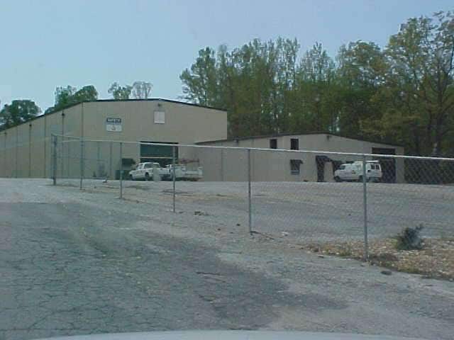
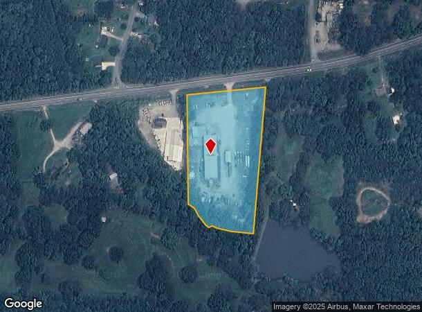
Property Record
2668 W Highway 166, Carrollton, GA 30117

NEARBY LISTINGS FOR SALE OR LEASE
Property Detail
2668 W Highway 166
Atlanta-Sandy Springs-Roswell, GA
Danny Turner Surv
077-0313
COMM BLDG/4.91AC HWY 166 W
Officebuilding
Carroll
X
Georgia
13045C0261D
91
2025
4.91 AC
2025
W Carroll County
911102
Atlanta
15,380 SF
DEMOGRAPHICS near 2668 W Highway 166
1 Mile
3 Mile
5 Mile
2024 Total Population
2,047
17,991
38,359
2029 Population
2,260
19,919
42,564
Pop Growth 2024-2029
+ 10.41%
+ 10.72%
+ 10.96%
Average Age
39
34
36
2024 Total Households
757
6,220
13,895
HH Growth 2024-2029
+ 10.70%
+ 11.14%
+ 11.22%
Median Household Inc
$102,439
$43,727
$46,579
Avg Household Size
2.60
2.50
2.50
2024 Avg HH Vehicles
3.00
2.00
2.00
Median Home Value
$356,637
$276,104
$231,779
Median Year Built
1981
1986
1985
Nearby Places
Map Layers
Map Styles
 Street
 Aerial
- Restaurants
- Banks
- Shops
- Fitness
- Groceries
Nearby Properties
Address
Land Use
TOTAL SIZE
Lot Size
Zoning
Address
Land Use
TOTAL SIZE
Lot Size
Zoning
53.04 AC
OI
Address
Land Use
TOTAL SIZE
Lot Size
Zoning
50,000 SF
28.63 AC
HS
Address
Land Use
TOTAL SIZE
Lot Size
Zoning
261,905 SF
64.74 AC
R2
Address
Land Use
TOTAL SIZE
Lot Size
Zoning
351,903 SF
30.04 AC
C2
Address
Land Use
TOTAL SIZE
Lot Size
Zoning
39,268 SF
12.05 AC
RM-10
Address
Land Use
TOTAL SIZE
Lot Size
Zoning
32,778 SF
3.89 AC
OI
Address
Land Use
TOTAL SIZE
Lot Size
Zoning
35.33 AC
OI
Address
Land Use
TOTAL SIZE
Lot Size
Zoning
159,860 SF
20.74 AC
C2
Address
Land Use
TOTAL SIZE
Lot Size
Zoning
142,740 SF
8.13 AC
C2
Address
Land Use
TOTAL SIZE
Lot Size
Zoning
217,766 SF
28.46 AC
C2
Address
Land Use
TOTAL SIZE
Lot Size
Zoning
13,585 SF
14.93 AC
R3
Address
Land Use
TOTAL SIZE
Lot Size
Zoning
23,801 SF
14.78 AC
PD/R-M
Address
Land Use
TOTAL SIZE
Lot Size
Zoning
13,185 SF
26.29 AC
R4
Address
Land Use
TOTAL SIZE
Lot Size
Zoning
83,421 SF
4.28 AC
C2
Address
Land Use
TOTAL SIZE
Lot Size
Zoning
19,960 SF
0.53 AC
HS
Address
Land Use
TOTAL SIZE
Lot Size
Zoning
97,509 SF
15.50 AC
001
Address
Land Use
TOTAL SIZE
Lot Size
Zoning
138,903 SF
15.27 AC
C2
Address
Land Use
TOTAL SIZE
Lot Size
Zoning
7,700 SF
7.08 AC
R3
Address
Land Use
TOTAL SIZE
Lot Size
Zoning
17,102 SF
33.57 AC
R3
Address
Land Use
TOTAL SIZE
Lot Size
Zoning
17,000 SF
13.52 AC
R3
Address
Land Use
TOTAL SIZE
Lot Size
Zoning
109,900 SF
11.39 AC
C2
Address
Land Use
TOTAL SIZE
Lot Size
Zoning
3,240 SF
13.42 AC
C2
Address
Land Use
TOTAL SIZE
Lot Size
Zoning
19,840 SF
10.37 AC
R2
Address
Land Use
TOTAL SIZE
Lot Size
Zoning
119,925 SF
10.10 AC
OI/PUD
Address
Land Use
TOTAL SIZE
Lot Size
Zoning
30,985 SF
3.24 AC
HS
Address
Land Use
TOTAL SIZE
Lot Size
Zoning
49,314 SF
7.74 AC
001
Address
Land Use
TOTAL SIZE
Lot Size
Zoning
9,891 SF
11.54 AC
R3
Address
Land Use
TOTAL SIZE
Lot Size
Zoning
11,758 SF
3.91 AC
C2
Address
Land Use
TOTAL SIZE
Lot Size
Zoning
15 AC
R20
Address
Land Use
TOTAL SIZE
Lot Size
Zoning
89,273 SF
7.90 AC
C2
The World's #1 Commercial Real Estate Marketplace
Connect with us
© 2025 CoStar Group
The information above has been obtained from sources believed reliable. While we do not doubt its accuracy we have not verified it and make no guarantee, warranty or representation about it. It is your responsibility to independently confirm its accuracy and completeness. Any projections, opinions, assumptions, or estimates used are for example only and do not represent the current or future performance of the property. The value of this transaction to you depends on tax and other factors which should be evaluated by your tax, financial, and legal advisors. You and your advisors should conduct a careful, independent investigation of the property to determine to your satisfaction the suitability of the property for your needs.