Property Record
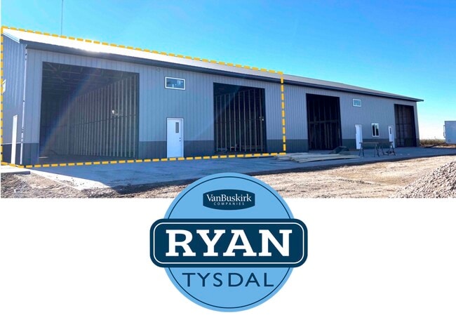
26681 483Rd Ave, Hartford, SD 57033


Current Lease Availabilities
Property Detail
26681 483Rd Ave
89979
Anderson`S Addition
Warehouse
TRACT 1 ANDERSON`S ADDITION SE14 26 101 48 SPLIT ROCK TOWNSHIP 101-48
X
Minnehaha
19119C0025D
South Dakota
2024
1.84 AC
2024
Sioux Falls
010300
Other Market Areas
6,000 SF
Sioux Falls, SD-MN
NEARBY LISTINGS FOR SALE OR LEASE
-
-
View all Hartford listings for lease on LoopNet.com
DEMOGRAPHICS near 26681 483Rd Ave
1 mile
3 mile
5 mile
2024 Total Population
140
969
15,269
2029 Population
151
1,047
17,105
Pop Growth 2024-2029
+ 7.86%
+ 8.05%
+ 12.02%
Average Age
42
41
35
2024 Total Households
50
346
5,494
HH Growth 2024-2029
+ 8.00%
+ 8.67%
+ 12.56%
Median Household Inc
$120,312
$118,298
$117,597
Avg Household Size
2.70
2.70
2.70
2024 Avg HH Vehicles
3.00
3.00
2.00
Median Home Value
$454,545
$447,887
$382,480
Median Year Built
1981
1982
2010
Nearby Places
Map Layers
Map Styles
 Street
 Aerial
Transit
 Traffic
 Biking
Places
Listings with unknown addresses are not visible on the map
- Restaurants
- Banks
- Shops
- Fitness
- Groceries
PUBLIC TRANSPORTATION
AIRPORT
Joe Foss Field
Drive
Walk
Distance
Joe Foss Field
37 min
13.9 mi
Freight Ports
Port Milwaukee
Drive
Walk
Distance
Port Milwaukee
547 min
500.7 mi
Nearby Properties
Address
Land Use
TOTAL SIZE
Lot Size
Zoning
Address
Land Use
TOTAL SIZE
Lot Size
Zoning
1,448 SF
205.96 AC
Address
Land Use
TOTAL SIZE
Lot Size
Zoning
7,549 SF
58.23 AC
A1
Address
Land Use
TOTAL SIZE
Lot Size
Zoning
5.86 AC
RC REC CON
Address
Land Use
TOTAL SIZE
Lot Size
Zoning
4,241 SF
0.87 AC
Address
Land Use
TOTAL SIZE
Lot Size
Zoning
7.65 AC
RC REC CON
Address
Land Use
TOTAL SIZE
Lot Size
Zoning
5.05 AC
RC REC CON
Address
Land Use
TOTAL SIZE
Lot Size
Zoning
5.85 AC
RC REC CON
Address
Land Use
TOTAL SIZE
Lot Size
Zoning
5.27 AC
RC REC CON
Address
Land Use
TOTAL SIZE
Lot Size
Zoning
3,967 SF
2.93 AC
RC;CONSERV
Address
Land Use
TOTAL SIZE
Lot Size
Zoning
4,624 SF
52.90 AC
A1
Address
Land Use
TOTAL SIZE
Lot Size
Zoning
6,480 SF
2.06 AC
Address
Land Use
TOTAL SIZE
Lot Size
Zoning
4,920 SF
5 AC
A1
Address
Land Use
TOTAL SIZE
Lot Size
Zoning
4.92 AC
RC REC CON
Address
Land Use
TOTAL SIZE
Lot Size
Zoning
3,385 SF
1.06 AC
PD
Address
Land Use
TOTAL SIZE
Lot Size
Zoning
4,570 SF
8 AC
A1
Address
Land Use
TOTAL SIZE
Lot Size
Zoning
4,663 SF
25.63 AC
A1
Address
Land Use
TOTAL SIZE
Lot Size
Zoning
5.46 AC
RC REC CON
Address
Land Use
TOTAL SIZE
Lot Size
Zoning
5.76 AC
RR RURAL R
Address
Land Use
TOTAL SIZE
Lot Size
Zoning
5,665 SF
36.28 AC
PD
Address
Land Use
TOTAL SIZE
Lot Size
Zoning
22,400 SF
8.87 AC
PD
Address
Land Use
TOTAL SIZE
Lot Size
Zoning
2,755 SF
28 AC
A1
Address
Land Use
TOTAL SIZE
Lot Size
Zoning
2,898 SF
1.80 AC
PD
Address
Land Use
TOTAL SIZE
Lot Size
Zoning
3,865 SF
5.02 AC
A1
Address
Land Use
TOTAL SIZE
Lot Size
Zoning
3.88 AC
RR RURAL R
Address
Land Use
TOTAL SIZE
Lot Size
Zoning
4,415 SF
9.01 AC
A1
Address
Land Use
TOTAL SIZE
Lot Size
Zoning
4.99 AC
RC REC CON
Address
Land Use
TOTAL SIZE
Lot Size
Zoning
2,191 SF
10.05 AC
A1
Address
Land Use
TOTAL SIZE
Lot Size
Zoning
5,852 SF
10.21 AC
RC
Address
Land Use
TOTAL SIZE
Lot Size
Zoning
2,208 SF
20.31 AC
RC;CONSERV
Address
Land Use
TOTAL SIZE
Lot Size
Zoning
3,444 SF
7.89 AC
PDRC
The World's #1 Commercial Real Estate Marketplace
Connect with us
© 2026 CoStar Group
The information above has been obtained from sources believed reliable. While we do not doubt its accuracy we have not verified it and make no guarantee, warranty or representation about it. It is your responsibility to independently confirm its accuracy and completeness. Any projections, opinions, assumptions, or estimates used are for example only and do not represent the current or future performance of the property. The value of this transaction to you depends on tax and other factors which should be evaluated by your tax, financial, and legal advisors. You and your advisors should conduct a careful, independent investigation of the property to determine to your satisfaction the suitability of the property for your needs.