Property Record
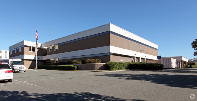
267 W Front St, Burlington, NC 27215


NEARBY LISTINGS FOR SALE OR LEASE
Property Detail
267 W Front St
135616
POLICE STATION 003A-10-1
Officebuilding
Alamance
X
North Carolina
3710887500K
2.40 AC
2025
Burlington CBD
2025
Greensboro/Winston-Salem
020100
Burlington, NC
30,660 SF
DEMOGRAPHICS near 267 W Front St
1 Mile
3 Mile
5 Mile
2024 Total Population
10,860
56,545
99,762
2029 Population
11,717
60,978
107,747
Pop Growth 2024-2029
+ 7.89%
+ 7.84%
+ 8.00%
Average Age
40
39
39
2024 Total Households
4,427
22,801
39,420
HH Growth 2024-2029
+ 8.04%
+ 7.99%
+ 8.26%
Median Household Inc
$34,152
$45,703
$51,873
Avg Household Size
2.30
2.40
2.30
2024 Avg HH Vehicles
2.00
2.00
2.00
Median Home Value
$148,577
$144,233
$175,559
Median Year Built
1956
1970
1979
Nearby Places
Map Layers
Map Styles
 Street
 Aerial
- Restaurants
- Banks
- Shops
- Fitness
- Groceries
PUBLIC TRANSPORTATION
COMMUTER RAIL
Burlington Station (Piedmont - North Carolina by Train (NC Train))
DRIVE
WALK
Distance
Burlington Station (Piedmont - North Carolina by Train (NC Train))
1 min
9 min
0.3 mi
AIRPORT
Piedmont Triad International
DRIVE
WALK
Distance
Piedmont Triad International
49 min
36.1 mi
Nearby Properties
Address
Land Use
TOTAL SIZE
Lot Size
Zoning
Address
Land Use
TOTAL SIZE
Lot Size
Zoning
2,315 SF
55.43 AC
I 1
Address
Land Use
TOTAL SIZE
Lot Size
Zoning
177,145 SF
47.79 AC
R 15
Address
Land Use
TOTAL SIZE
Lot Size
Zoning
128,458 SF
70.20 AC
IO CI
Address
Land Use
TOTAL SIZE
Lot Size
Zoning
10,744 SF
24.60 AC
MF A
Address
Land Use
TOTAL SIZE
Lot Size
Zoning
40,220 SF
12.45 AC
MF A
Address
Land Use
TOTAL SIZE
Lot Size
Zoning
84,881 SF
52.87 AC
I1
Address
Land Use
TOTAL SIZE
Lot Size
Zoning
72,164 SF
73.50 AC
Address
Land Use
TOTAL SIZE
Lot Size
Zoning
714,245 SF
109.43 AC
I 1
Address
Land Use
TOTAL SIZE
Lot Size
Zoning
110,612 SF
1 AC
B 3
Address
Land Use
TOTAL SIZE
Lot Size
Zoning
9,672 SF
10.77 AC
MF A
Address
Land Use
TOTAL SIZE
Lot Size
Zoning
23,992 SF
25.66 AC
R 9
Address
Land Use
TOTAL SIZE
Lot Size
Zoning
19,872 SF
9.80 AC
Address
Land Use
TOTAL SIZE
Lot Size
Zoning
71,962 SF
5.98 AC
O I
Address
Land Use
TOTAL SIZE
Lot Size
Zoning
31,585 SF
18.69 AC
MF A
Address
Land Use
TOTAL SIZE
Lot Size
Zoning
216,968 SF
25.50 AC
CB
Address
Land Use
TOTAL SIZE
Lot Size
Zoning
40,440 SF
23.57 AC
R 9
Address
Land Use
TOTAL SIZE
Lot Size
Zoning
101,469 SF
4.28 AC
CR
Address
Land Use
TOTAL SIZE
Lot Size
Zoning
23,268 SF
6.11 AC
Address
Land Use
TOTAL SIZE
Lot Size
Zoning
59,897 SF
15.40 AC
Address
Land Use
TOTAL SIZE
Lot Size
Zoning
59,904 SF
9.11 AC
B 2
Address
Land Use
TOTAL SIZE
Lot Size
Zoning
17,073 SF
7.59 AC
R 9
Address
Land Use
TOTAL SIZE
Lot Size
Zoning
15,512 SF
6.54 AC
MF A
Address
Land Use
TOTAL SIZE
Lot Size
Zoning
102,888 SF
11.15 AC
B 2
Address
Land Use
TOTAL SIZE
Lot Size
Zoning
32,480 SF
18.44 AC
R 9
Address
Land Use
TOTAL SIZE
Lot Size
Zoning
65,480 SF
11.09 AC
B 2
Address
Land Use
TOTAL SIZE
Lot Size
Zoning
118,078 SF
8.81 AC
PI
Address
Land Use
TOTAL SIZE
Lot Size
Zoning
2,923 SF
10.13 AC
Address
Land Use
TOTAL SIZE
Lot Size
Zoning
158,339 SF
16.34 AC
Address
Land Use
TOTAL SIZE
Lot Size
Zoning
77,046 SF
1.61 AC
I 3
Address
Land Use
TOTAL SIZE
Lot Size
Zoning
20,000 SF
17.24 AC
I 1A
The World's #1 Commercial Real Estate Marketplace
Connect with us
© 2025 CoStar Group
The information above has been obtained from sources believed reliable. While we do not doubt its accuracy we have not verified it and make no guarantee, warranty or representation about it. It is your responsibility to independently confirm its accuracy and completeness. Any projections, opinions, assumptions, or estimates used are for example only and do not represent the current or future performance of the property. The value of this transaction to you depends on tax and other factors which should be evaluated by your tax, financial, and legal advisors. You and your advisors should conduct a careful, independent investigation of the property to determine to your satisfaction the suitability of the property for your needs.