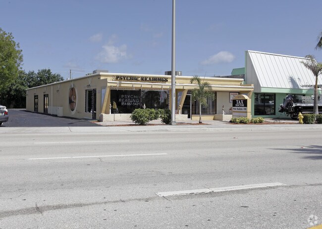
Property Record
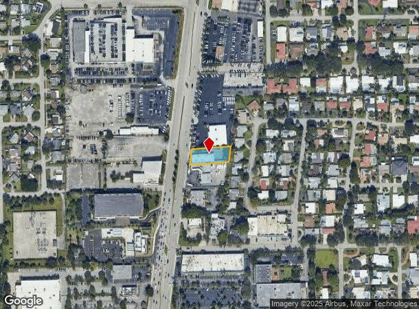
2670 N Federal Hwy, Pompano Beach, FL 33064

NEARBY LISTINGS FOR SALE OR LEASE
Property Detail
2670 N Federal Hwy
Fort Lauderdale-Pompano Beach-Deerfield Beach, FL
Hillsboro Estates 39-46 B
48-43-19-16-0040
HILLSBORO ESTATES 39-46 B TR A N 80 OF S 130
Officebuilding
Broward
X
Florida
12011C0188J
a
2024
0.36 AC
2025
Pompano Beach
030100
South Florida
4,268 SF
DEMOGRAPHICS near 2670 N Federal Hwy
1 Mile
3 Mile
5 Mile
2024 Total Population
15,950
115,126
250,725
2029 Population
15,929
116,067
254,855
Pop Growth 2024-2029
(0.13%)
+ 0.82%
+ 1.65%
Average Age
45
43
46
2024 Total Households
6,844
48,028
112,906
HH Growth 2024-2029
(0.22%)
+ 0.98%
+ 1.97%
Median Household Inc
$68,318
$60,712
$58,270
Avg Household Size
2.20
2.30
2.10
2024 Avg HH Vehicles
2.00
2.00
1.00
Median Home Value
$329,716
$366,413
$336,143
Median Year Built
1966
1972
1975
Nearby Places
Map Layers
Map Styles
 Street
 Aerial
- Restaurants
- Banks
- Shops
- Fitness
- Groceries
PUBLIC TRANSPORTATION
COMMUTER RAIL
Pompano Beach (Tri-County Commuter - South Florida Regional Transportation Authority (Tri-Rail))
DRIVE
WALK
Distance
Pompano Beach (Tri-County Commuter - South Florida Regional Transportation Authority (Tri-Rail))
8 min
3.6 mi
Deerfield Beach (Tri-County Commuter - South Florida Regional Transportation Authority (Tri-Rail))
DRIVE
WALK
Distance
Deerfield Beach (Tri-County Commuter - South Florida Regional Transportation Authority (Tri-Rail))
13 min
6.7 mi
AIRPORT
Fort Lauderdale/Hollywood International
DRIVE
WALK
Distance
Fort Lauderdale/Hollywood International
29 min
19.0 mi
Palm Beach International
DRIVE
WALK
Distance
Palm Beach International
45 min
34.1 mi
Miami International
DRIVE
WALK
Distance
Miami International
66 min
44.2 mi
Freight Ports
Port Everglades
DRIVE
WALK
Distance
Port Everglades
27 min
18.0 mi
SALE & LEASE HISTORY
LISTING DATE
SALE/LEASE

Nov 29, 2016
For Lease
Jan 31, 2017
For Sale
Aug 08, 2018
For Lease
Aug 07, 2019
For Sale
Apr 11, 2017
For Sale
Nearby Properties
Address
Land Use
TOTAL SIZE
Lot Size
Zoning
Address
Land Use
TOTAL SIZE
Lot Size
Zoning
696,020 SF
31.74 AC
OPC
Address
Land Use
TOTAL SIZE
Lot Size
Zoning
513,748 SF
2.99 AC
TO-EOD
Address
Land Use
TOTAL SIZE
Lot Size
Zoning
484,380 SF
137.82 AC
T
Address
Land Use
TOTAL SIZE
Lot Size
Zoning
285,335 SF
8.56 AC
RM-45
Address
Land Use
TOTAL SIZE
Lot Size
Zoning
184,184 SF
2.98 AC
RM-45/HR
Address
Land Use
TOTAL SIZE
Lot Size
Zoning
392,222 SF
5.33 AC
RPUD
Address
Land Use
TOTAL SIZE
Lot Size
Zoning
406,839 SF
1.61 AC
RPUD
Address
Land Use
TOTAL SIZE
Lot Size
Zoning
161,512 SF
16.39 AC
RPC
Address
Land Use
TOTAL SIZE
Lot Size
Zoning
434,859 SF
38.72 AC
CF
Address
Land Use
TOTAL SIZE
Lot Size
Zoning
399,854 SF
1.60 AC
TO-EOD
Address
Land Use
TOTAL SIZE
Lot Size
Zoning
374,776 SF
23.52 AC
I-1
Address
Land Use
TOTAL SIZE
Lot Size
Zoning
435,201 SF
23.78 AC
I-1
Address
Land Use
TOTAL SIZE
Lot Size
Zoning
313,030 SF
37.22 AC
CF
Address
Land Use
TOTAL SIZE
Lot Size
Zoning
192,214 SF
10.84 AC
B-3/PCD
Address
Land Use
TOTAL SIZE
Lot Size
Zoning
171,306 SF
0.81 AC
TO-EOD
Address
Land Use
TOTAL SIZE
Lot Size
Zoning
244,452 SF
13.10 AC
RM-20
Address
Land Use
TOTAL SIZE
Lot Size
Zoning
222,660 SF
18.22 AC
CF
Address
Land Use
TOTAL SIZE
Lot Size
Zoning
152,273 SF
20.03 AC
B-3
Address
Land Use
TOTAL SIZE
Lot Size
Zoning
144,205 SF
5 AC
RM-25
Address
Land Use
TOTAL SIZE
Lot Size
Zoning
315,368 SF
25.22 AC
I-1
Address
Land Use
TOTAL SIZE
Lot Size
Zoning
25,003 SF
34.83 AC
PR
Address
Land Use
TOTAL SIZE
Lot Size
Zoning
139,746 SF
17.86 AC
B-3
Address
Land Use
TOTAL SIZE
Lot Size
Zoning
49,409 SF
70.79 AC
CF
Address
Land Use
TOTAL SIZE
Lot Size
Zoning
115,200 SF
1.18 AC
RM-45
Address
Land Use
TOTAL SIZE
Lot Size
Zoning
248,682 SF
15.10 AC
I-1/PCD
Address
Land Use
TOTAL SIZE
Lot Size
Zoning
202,384 SF
12.63 AC
I-1
Address
Land Use
TOTAL SIZE
Lot Size
Zoning
209,517 SF
17.74 AC
I-1C
Address
Land Use
TOTAL SIZE
Lot Size
Zoning
16,199 SF
51.78 AC
T-1C
Address
Land Use
TOTAL SIZE
Lot Size
Zoning
184,360 SF
8.97 AC
RM-15
Address
Land Use
TOTAL SIZE
Lot Size
Zoning
89,478 SF
0.89 AC
AOD
The World's #1 Commercial Real Estate Marketplace
Connect with us
© 2025 CoStar Group
The information above has been obtained from sources believed reliable. While we do not doubt its accuracy we have not verified it and make no guarantee, warranty or representation about it. It is your responsibility to independently confirm its accuracy and completeness. Any projections, opinions, assumptions, or estimates used are for example only and do not represent the current or future performance of the property. The value of this transaction to you depends on tax and other factors which should be evaluated by your tax, financial, and legal advisors. You and your advisors should conduct a careful, independent investigation of the property to determine to your satisfaction the suitability of the property for your needs.