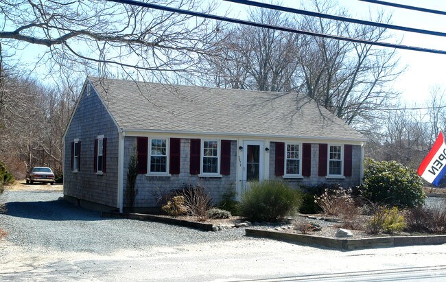
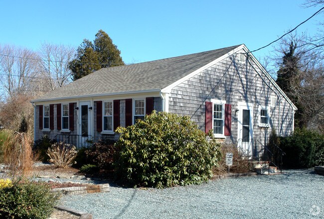
Property Record
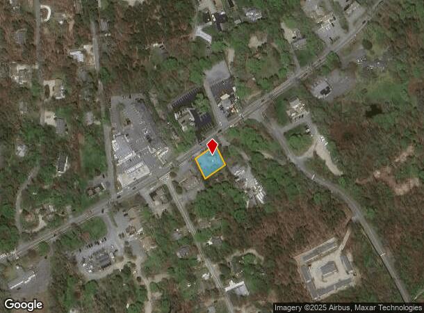
2672 Main St, Brewster, MA 02631
NEARBY LISTINGS FOR SALE OR LEASE
Property Detail
2672 Main St
Officebuilding
Barnstable
X
Massachusetts
25001C0418J
0.21 AC
2025
Other Market Areas
2025
Barnstable Town, MA
010800
BREW-000089-000000-000025
896 SF
DEMOGRAPHICS near 2672 Main St
1 Mile
3 Mile
5 Mile
2024 Total Population
2,949
10,033
22,714
2029 Population
3,186
10,591
23,451
Pop Growth 2024-2029
+ 8.04%
+ 5.56%
+ 3.24%
Average Age
52
52
52
2024 Total Households
1,434
4,683
10,421
HH Growth 2024-2029
+ 7.81%
+ 5.49%
+ 3.08%
Median Household Inc
$103,792
$93,463
$89,664
Avg Household Size
2.00
2.10
2.10
2024 Avg HH Vehicles
2.00
2.00
2.00
Median Home Value
$574,962
$603,767
$615,750
Median Year Built
1983
1982
1980
Nearby Places
Map Layers
Map Styles
 Street
 Aerial
- Restaurants
- Banks
- Shops
- Fitness
- Groceries
SALE & LEASE HISTORY
LISTING DATE
SALE/LEASE

Apr 19, 2017
For Sale
Nearby Properties
Address
Land Use
TOTAL SIZE
Lot Size
Zoning
Address
Land Use
TOTAL SIZE
Lot Size
Zoning
108,575 SF
0.48 AC
RESD.
Address
Land Use
TOTAL SIZE
Lot Size
Zoning
4,752 SF
54.92 AC
RESD.
Address
Land Use
TOTAL SIZE
Lot Size
Zoning
71,466 SF
12.15 AC
GB
Address
Land Use
TOTAL SIZE
Lot Size
Zoning
2,661 SF
45.06 AC
RESD.
Address
Land Use
TOTAL SIZE
Lot Size
Zoning
37,957 SF
8.40 AC
RESD.
Address
Land Use
TOTAL SIZE
Lot Size
Zoning
83,860 SF
9.96 AC
RESD.
Address
Land Use
TOTAL SIZE
Lot Size
Zoning
5,412 SF
128.90 AC
RESD.
Address
Land Use
TOTAL SIZE
Lot Size
Zoning
93,832 SF
22.68 AC
COMM H
Address
Land Use
TOTAL SIZE
Lot Size
Zoning
14,406 SF
14.18 AC
GB
Address
Land Use
TOTAL SIZE
Lot Size
Zoning
59,364 SF
28.65 AC
COMM H
Address
Land Use
TOTAL SIZE
Lot Size
Zoning
960 SF
14.20 AC
RESD.
Address
Land Use
TOTAL SIZE
Lot Size
Zoning
9,540 SF
51.23 AC
Address
Land Use
TOTAL SIZE
Lot Size
Zoning
11,952 SF
26.20 AC
RESD.
Address
Land Use
TOTAL SIZE
Lot Size
Zoning
600 SF
6 AC
RESD.
Address
Land Use
TOTAL SIZE
Lot Size
Zoning
2,342 SF
18.70 AC
RESD.
Address
Land Use
TOTAL SIZE
Lot Size
Zoning
4,208 SF
2.86 AC
RESD.
Address
Land Use
TOTAL SIZE
Lot Size
Zoning
8,432 SF
3.95 AC
RESD.
Address
Land Use
TOTAL SIZE
Lot Size
Zoning
480 SF
3.33 AC
RESD.
Address
Land Use
TOTAL SIZE
Lot Size
Zoning
12,778 SF
14.40 AC
COMM H
Address
Land Use
TOTAL SIZE
Lot Size
Zoning
23,078 SF
3.02 AC
GB
Address
Land Use
TOTAL SIZE
Lot Size
Zoning
4.87 AC
R-60
Address
Land Use
TOTAL SIZE
Lot Size
Zoning
18,844 SF
4.77 AC
RESD.
Address
Land Use
TOTAL SIZE
Lot Size
Zoning
4,762 SF
1.85 AC
RESD.
Address
Land Use
TOTAL SIZE
Lot Size
Zoning
103.35 AC
INDUST
Address
Land Use
TOTAL SIZE
Lot Size
Zoning
135 AC
RESD.
Address
Land Use
TOTAL SIZE
Lot Size
Zoning
3,757 SF
0.47 AC
RESD.
Address
Land Use
TOTAL SIZE
Lot Size
Zoning
4,459 SF
10 AC
RESD.
Address
Land Use
TOTAL SIZE
Lot Size
Zoning
3,236 SF
0.57 AC
RESD.
Address
Land Use
TOTAL SIZE
Lot Size
Zoning
2,032 SF
0.79 AC
RESD.
Address
Land Use
TOTAL SIZE
Lot Size
Zoning
The World's #1 Commercial Real Estate Marketplace
Connect with us
© 2026 CoStar Group
The information above has been obtained from sources believed reliable. While we do not doubt its accuracy we have not verified it and make no guarantee, warranty or representation about it. It is your responsibility to independently confirm its accuracy and completeness. Any projections, opinions, assumptions, or estimates used are for example only and do not represent the current or future performance of the property. The value of this transaction to you depends on tax and other factors which should be evaluated by your tax, financial, and legal advisors. You and your advisors should conduct a careful, independent investigation of the property to determine to your satisfaction the suitability of the property for your needs.