Property Record
26730 Mccall Blvd, Menifee, CA 92586
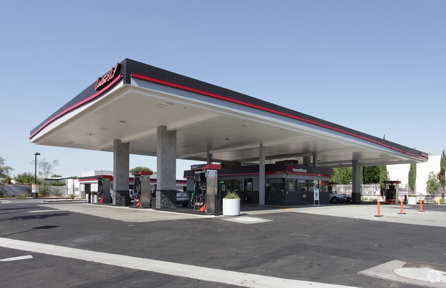


Property Detail
26730 Mccall Blvd
335-191-001
LOT 3 MB 056/080 TR 3614
Servicestation
Riverside
CP
California
B and X Area of moderate flood hazard, usually the area between the limits of the 100-year and 500-year floods.
3
2024
0.66 AC
2025
South Riverside
042741
Inland Empire (California)
1,088 SF
Riverside-San Bernardino-Ontario, CA
NEARBY LISTINGS FOR SALE OR LEASE
DEMOGRAPHICS near 26730 Mccall Blvd
1 mile
3 mile
5 mile
2025 Total Population
11,703
73,123
152,743
2030 Population
12,016
75,729
158,678
Pop Growth 2025-2030
+ 2.67%
+ 3.56%
+ 3.89%
Average Age
56
42
39
2025 Total Households
5,855
25,748
48,557
HH Growth 2025-2030
+ 2.15%
+ 3.02%
+ 3.40%
Median Household Inc
$47,669
$80,018
$93,110
Avg Household Size
2.00
2.80
3.10
2025 Avg HH Vehicles
2.00
2.00
2.00
Median Home Value
$339,524
$497,275
$590,375
Median Year Built
1976
1995
1999
Nearby Places
Map Layers
Map Styles
 Street
 Aerial
Layers
 Traffic
 Biking
Places
Listings with unknown addresses are not visible on the map
- Restaurants
- Banks
- Shops
- Fitness
- Groceries
PUBLIC TRANSPORTATION
COMMUTER RAIL
South Perris (Metrolink 91-Perris Valley Line - Metrolink Trains)
Drive
Walk
Distance
South Perris (Metrolink 91-Perris Valley Line - Metrolink Trains)
8 min
4.7 mi
Perris Downtown (Metrolink 91-Perris Valley Line - Metrolink Trains)
Drive
Walk
Distance
Perris Downtown (Metrolink 91-Perris Valley Line - Metrolink Trains)
11 min
7.2 mi
Freight Ports
Port of Long Beach
Drive
Walk
Distance
Port of Long Beach
97 min
74.5 mi
SALE & LEASE HISTORY
LISTING DATE
SALE/LEASE

Aug 20, 2024
For Sale
Aug 06, 2025
For Sale
Nearby Properties
Address
Land Use
TOTAL SIZE
Lot Size
Zoning
Address
Land Use
TOTAL SIZE
Lot Size
Zoning
61,012 SF
19.12 AC
SPZONE
Address
Land Use
TOTAL SIZE
Lot Size
Zoning
33,793 SF
8.47 AC
Address
Land Use
TOTAL SIZE
Lot Size
Zoning
123,058 SF
17.09 AC
R3
Address
Land Use
TOTAL SIZE
Lot Size
Zoning
31,477 SF
4.24 AC
RR
Address
Land Use
TOTAL SIZE
Lot Size
Zoning
128,991 SF
10.20 AC
SPZONE
Address
Land Use
TOTAL SIZE
Lot Size
Zoning
76,301 SF
9.63 AC
Address
Land Use
TOTAL SIZE
Lot Size
Zoning
9.22 AC
CBOOK
Address
Land Use
TOTAL SIZE
Lot Size
Zoning
134,641 SF
5.39 AC
Address
Land Use
TOTAL SIZE
Lot Size
Zoning
130,830 SF
26 AC
SP
Address
Land Use
TOTAL SIZE
Lot Size
Zoning
172,887 SF
15.10 AC
SPZONE
Address
Land Use
TOTAL SIZE
Lot Size
Zoning
40,349 SF
9.89 AC
R3
Address
Land Use
TOTAL SIZE
Lot Size
Zoning
61,487 SF
5.73 AC
Address
Land Use
TOTAL SIZE
Lot Size
Zoning
154,086 SF
9.34 AC
R1
Address
Land Use
TOTAL SIZE
Lot Size
Zoning
116,410 SF
10.88 AC
C1CP
Address
Land Use
TOTAL SIZE
Lot Size
Zoning
104,208 SF
10.96 AC
Address
Land Use
TOTAL SIZE
Lot Size
Zoning
139,410 SF
13 AC
SPZONE
Address
Land Use
TOTAL SIZE
Lot Size
Zoning
5,000 SF
4.07 AC
RR
Address
Land Use
TOTAL SIZE
Lot Size
Zoning
38,106 SF
3.50 AC
SP
Address
Land Use
TOTAL SIZE
Lot Size
Zoning
13.95 AC
Address
Land Use
TOTAL SIZE
Lot Size
Zoning
63,039 SF
2.80 AC
SP
Address
Land Use
TOTAL SIZE
Lot Size
Zoning
56,135 SF
3.45 AC
SPZONE
Address
Land Use
TOTAL SIZE
Lot Size
Zoning
83,814 SF
8.87 AC
CPS
Address
Land Use
TOTAL SIZE
Lot Size
Zoning
97,942 SF
11 AC
Address
Land Use
TOTAL SIZE
Lot Size
Zoning
89,137 SF
7.39 AC
SPZONE
Address
Land Use
TOTAL SIZE
Lot Size
Zoning
56,284 SF
5.06 AC
C1CP
Address
Land Use
TOTAL SIZE
Lot Size
Zoning
14,081 SF
1.39 AC
SPZONE
Address
Land Use
TOTAL SIZE
Lot Size
Zoning
86,590 SF
10.97 AC
MM
Address
Land Use
TOTAL SIZE
Lot Size
Zoning
27,252 SF
5.42 AC
R6
The World's #1 Commercial Real Estate Marketplace
Connect with us
© 2026 CoStar Group
The information above has been obtained from sources believed reliable. While we do not doubt its accuracy we have not verified it and make no guarantee, warranty or representation about it. It is your responsibility to independently confirm its accuracy and completeness. Any projections, opinions, assumptions, or estimates used are for example only and do not represent the current or future performance of the property. The value of this transaction to you depends on tax and other factors which should be evaluated by your tax, financial, and legal advisors. You and your advisors should conduct a careful, independent investigation of the property to determine to your satisfaction the suitability of the property for your needs.