Property Record
2674 N Eastman Rd, Midland, MI 48642
NEARBY LISTINGS FOR SALE OR LEASE
-
-
View all Midland listings for sale on LoopNet.com
Property Detail
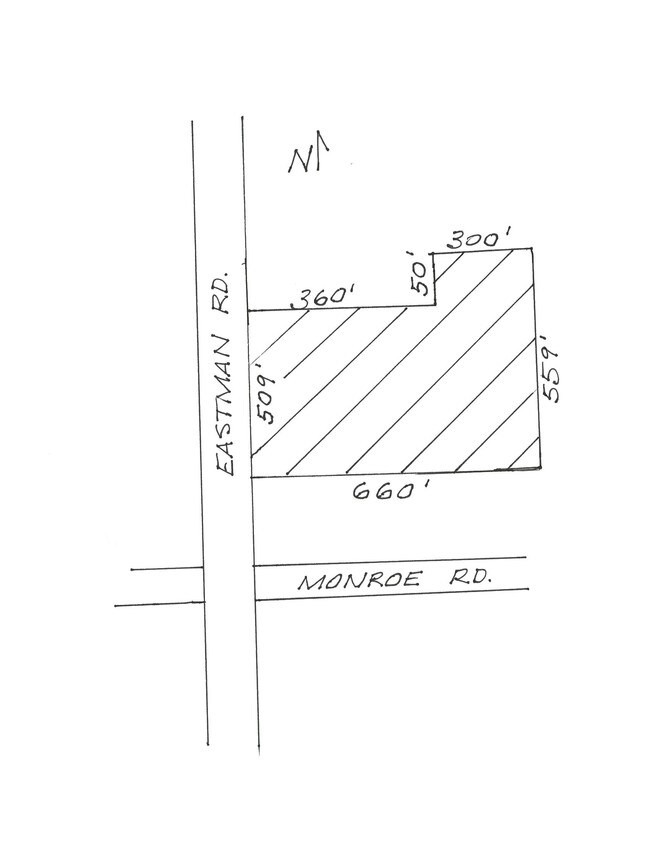
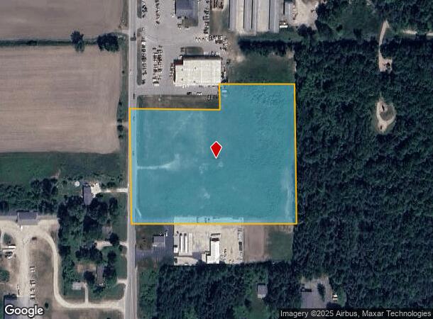
2674 N Eastman Rd
090-021-300-144-00
SEC 21 T15N R2E COM 629 FT N OF SW SEC COR, TH N 459 FT, E 360 FT, N 100 FT, E 300 FT, S 559 FT, W 660 FT.
Commercialacreage
Midland
X
Michigan
26111C0186E
7.65 AC
2024
Midland/Flint
2025
Other Market Areas
290902
Midland, MI
DEMOGRAPHICS near 2674 N Eastman Rd
1 Mile
3 Mile
5 Mile
2024 Total Population
706
13,750
40,971
2029 Population
706
13,739
40,894
Pop Growth 2024-2029
0.00%
(0.08%)
(0.19%)
Average Age
42
42
42
2024 Total Households
254
5,166
16,880
HH Growth 2024-2029
0.00%
(0.10%)
(0.20%)
Median Household Inc
$130,357
$108,075
$76,697
Avg Household Size
2.80
2.60
2.40
2024 Avg HH Vehicles
2.00
2.00
2.00
Median Home Value
$295,205
$263,905
$196,857
Median Year Built
1987
1983
1973
Nearby Places
Map Layers
Map Styles
 Street
 Aerial
- Restaurants
- Banks
- Shops
- Fitness
- Groceries
PUBLIC TRANSPORTATION
AIRPORT
MBS International
DRIVE
WALK
Distance
MBS International
26 min
16.8 mi
Freight Ports
Port of Toledo
DRIVE
WALK
Distance
Port of Toledo
201 min
175.3 mi
SALE & LEASE HISTORY
LISTING DATE
SALE/LEASE

Sep 24, 2016
For Sale
Nearby Properties
Address
Land Use
TOTAL SIZE
Lot Size
Zoning
Address
Land Use
TOTAL SIZE
Lot Size
Zoning
42,647 SF
12.42 AC
RA-4
Address
Land Use
TOTAL SIZE
Lot Size
Zoning
252,442 SF
70.03 AC
AG
Address
Land Use
TOTAL SIZE
Lot Size
Zoning
357,933 SF
33.35 AC
RC
Address
Land Use
TOTAL SIZE
Lot Size
Zoning
116,274 SF
4.59 AC
RC
Address
Land Use
TOTAL SIZE
Lot Size
Zoning
201,174 SF
27.52 AC
RC
Address
Land Use
TOTAL SIZE
Lot Size
Zoning
207,859 SF
21.12 AC
RC
Address
Land Use
TOTAL SIZE
Lot Size
Zoning
55,872 SF
3.85 AC
RC
Address
Land Use
TOTAL SIZE
Lot Size
Zoning
61,516 SF
5.31 AC
RC
Address
Land Use
TOTAL SIZE
Lot Size
Zoning
143.72 AC
LCMR
Address
Land Use
TOTAL SIZE
Lot Size
Zoning
53,950 SF
16.40 AC
RC
Address
Land Use
TOTAL SIZE
Lot Size
Zoning
64,769 SF
3.17 AC
RC
Address
Land Use
TOTAL SIZE
Lot Size
Zoning
81,009 SF
3.33 AC
RC
Address
Land Use
TOTAL SIZE
Lot Size
Zoning
74,532 SF
6.55 AC
RC
Address
Land Use
TOTAL SIZE
Lot Size
Zoning
88,104 SF
9 AC
RC
Address
Land Use
TOTAL SIZE
Lot Size
Zoning
62,440 SF
7.34 AC
RC
Address
Land Use
TOTAL SIZE
Lot Size
Zoning
38,127 SF
9.72 AC
IA
Address
Land Use
TOTAL SIZE
Lot Size
Zoning
35,826 SF
4.67 AC
RA-1
Address
Land Use
TOTAL SIZE
Lot Size
Zoning
100,336 SF
8.94 AC
RB
Address
Land Use
TOTAL SIZE
Lot Size
Zoning
102,455 SF
13.33 AC
RC
Address
Land Use
TOTAL SIZE
Lot Size
Zoning
114,465 SF
12.59 AC
RC
Address
Land Use
TOTAL SIZE
Lot Size
Zoning
52,037 SF
3.14 AC
OS
Address
Land Use
TOTAL SIZE
Lot Size
Zoning
33,828 SF
5.38 AC
RC
Address
Land Use
TOTAL SIZE
Lot Size
Zoning
92,094 SF
8.50 AC
RC
Address
Land Use
TOTAL SIZE
Lot Size
Zoning
63,219 SF
5.45 AC
OS
Address
Land Use
TOTAL SIZE
Lot Size
Zoning
50,171 SF
2 AC
RC
Address
Land Use
TOTAL SIZE
Lot Size
Zoning
35,027 SF
6.21 AC
RA-1
Address
Land Use
TOTAL SIZE
Lot Size
Zoning
20,389 SF
3.25 AC
RC
Address
Land Use
TOTAL SIZE
Lot Size
Zoning
39,471 SF
2.51 AC
RB
Address
Land Use
TOTAL SIZE
Lot Size
Zoning
26,485 SF
3.19 AC
RC
Address
Land Use
TOTAL SIZE
Lot Size
Zoning
30,881 SF
2.62 AC
RC
The World's #1 Commercial Real Estate Marketplace
Connect with us
© 2025 CoStar Group
The information above has been obtained from sources believed reliable. While we do not doubt its accuracy we have not verified it and make no guarantee, warranty or representation about it. It is your responsibility to independently confirm its accuracy and completeness. Any projections, opinions, assumptions, or estimates used are for example only and do not represent the current or future performance of the property. The value of this transaction to you depends on tax and other factors which should be evaluated by your tax, financial, and legal advisors. You and your advisors should conduct a careful, independent investigation of the property to determine to your satisfaction the suitability of the property for your needs.