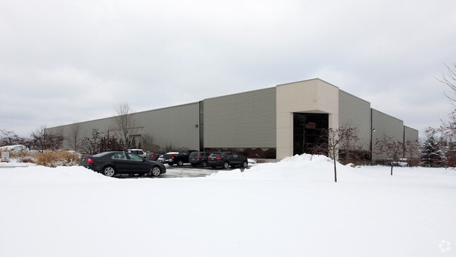
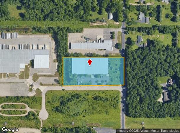
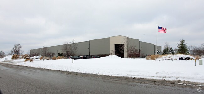
Property Record
2676 S 26Th St, Kalamazoo, MI 49048
NEARBY LISTINGS FOR SALE OR LEASE
Property Detail
2676 S 26Th St
07-30-430-026
SEC 30-2-10 THAT PART OF THE NORTHEAST 1/4 OF THE SOUTHEAST 1/4 OF SECTION 30, TOWN 2 SOUTH, RANGE 10 WEST, DESCRIPTION:
Industrialgeneral
Kalamazoo
X
Michigan
26077C0195E
3.85 AC
2024
Southern Kalamazoo County
2025
West Michigan
006702
Kalamazoo-Portage, MI
36,000 SF
DEMOGRAPHICS near 2676 S 26Th St
1 Mile
3 Mile
5 Mile
2024 Total Population
510
24,512
84,316
2029 Population
507
24,451
84,298
Pop Growth 2024-2029
(0.59%)
(0.25%)
(0.02%)
Average Age
42
37
37
2024 Total Households
197
9,868
35,768
HH Growth 2024-2029
(0.51%)
(0.33%)
(0.03%)
Median Household Inc
$60,242
$52,226
$50,773
Avg Household Size
2.40
2.40
2.20
2024 Avg HH Vehicles
2.00
2.00
2.00
Median Home Value
$188,775
$127,448
$147,815
Median Year Built
1961
1956
1957
Nearby Places
Map Layers
Map Styles
 Street
 Aerial
- Restaurants
- Banks
- Shops
- Fitness
- Groceries
PUBLIC TRANSPORTATION
COMMUTER RAIL
DRIVE
WALK
Distance
9 min
5.1 mi
AIRPORT
Kalamazoo/Battle Creek International
DRIVE
WALK
Distance
Kalamazoo/Battle Creek International
13 min
3.9 mi
Nearby Properties
Address
Land Use
TOTAL SIZE
Lot Size
Zoning
Address
Land Use
TOTAL SIZE
Lot Size
Zoning
82,520 SF
39.35 AC
I-1
Address
Land Use
TOTAL SIZE
Lot Size
Zoning
33.60 AC
Address
Land Use
TOTAL SIZE
Lot Size
Zoning
61.61 AC
Address
Land Use
TOTAL SIZE
Lot Size
Zoning
134,876 SF
16.45 AC
RM-15
Address
Land Use
TOTAL SIZE
Lot Size
Zoning
17,858 SF
15.27 AC
RM-1
Address
Land Use
TOTAL SIZE
Lot Size
Zoning
498,424 SF
41.72 AC
M-2
Address
Land Use
TOTAL SIZE
Lot Size
Zoning
298,908 SF
40.33 AC
Address
Land Use
TOTAL SIZE
Lot Size
Zoning
606,439 SF
34.61 AC
M-2
Address
Land Use
TOTAL SIZE
Lot Size
Zoning
Address
Land Use
TOTAL SIZE
Lot Size
Zoning
80,064 SF
6.13 AC
M-1
Address
Land Use
TOTAL SIZE
Lot Size
Zoning
157,123 SF
M
Address
Land Use
TOTAL SIZE
Lot Size
Zoning
793,429 SF
36.48 AC
M
Address
Land Use
TOTAL SIZE
Lot Size
Zoning
393,522 SF
33.31 AC
M-2
Address
Land Use
TOTAL SIZE
Lot Size
Zoning
98,401 SF
2.94 AC
RM-15
Address
Land Use
TOTAL SIZE
Lot Size
Zoning
10.04 AC
I-1
Address
Land Use
TOTAL SIZE
Lot Size
Zoning
Address
Land Use
TOTAL SIZE
Lot Size
Zoning
79,947 SF
12.13 AC
M
Address
Land Use
TOTAL SIZE
Lot Size
Zoning
69,987 SF
8.58 AC
RM-15
Address
Land Use
TOTAL SIZE
Lot Size
Zoning
2,286 SF
74.31 AC
Address
Land Use
TOTAL SIZE
Lot Size
Zoning
142,107 SF
14.97 AC
M-1
Address
Land Use
TOTAL SIZE
Lot Size
Zoning
10.76 AC
N/A
Address
Land Use
TOTAL SIZE
Lot Size
Zoning
478,944 SF
18.41 AC
M
Address
Land Use
TOTAL SIZE
Lot Size
Zoning
313,777 SF
15.30 AC
M-2
Address
Land Use
TOTAL SIZE
Lot Size
Zoning
80,640 SF
14.04 AC
Address
Land Use
TOTAL SIZE
Lot Size
Zoning
Address
Land Use
TOTAL SIZE
Lot Size
Zoning
164,320 SF
5.90 AC
M
Address
Land Use
TOTAL SIZE
Lot Size
Zoning
673,310 SF
29.33 AC
A-H
Address
Land Use
TOTAL SIZE
Lot Size
Zoning
116,384 SF
M-2
Address
Land Use
TOTAL SIZE
Lot Size
Zoning
129,031 SF
16.34 AC
LD
Address
Land Use
TOTAL SIZE
Lot Size
Zoning
79,466 SF
5.64 AC
RM-15
The World's #1 Commercial Real Estate Marketplace
Connect with us
© 2025 CoStar Group
The information above has been obtained from sources believed reliable. While we do not doubt its accuracy we have not verified it and make no guarantee, warranty or representation about it. It is your responsibility to independently confirm its accuracy and completeness. Any projections, opinions, assumptions, or estimates used are for example only and do not represent the current or future performance of the property. The value of this transaction to you depends on tax and other factors which should be evaluated by your tax, financial, and legal advisors. You and your advisors should conduct a careful, independent investigation of the property to determine to your satisfaction the suitability of the property for your needs.