Property Record
2676 S Oakwood Rd, Oshkosh, WI 54904


NEARBY LISTINGS FOR SALE OR LEASE
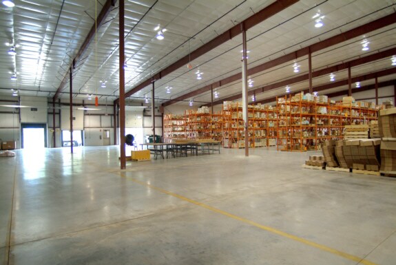
Property Detail
2676 S Oakwood Rd
Oshkosh-Neenah, WI
Certified Survey Map No 4879
13-29100400
LOT 1 AND OUTLOT 1 CSM 4879 DOC #1151975 R OF D NW1/4 SW1/4&SW1/4 NW1/4 SEC 33-18-16 ALSO LOT 1 CSM 3155 DOC #922142 ROF D
Industrialgeneral
Winnebago
X
Wisconsin
55039C0100F
1
2024
16.34 AC
2024
Appleton/Oshkosh
001801
Other Market Areas
DEMOGRAPHICS near 2676 S Oakwood Rd
1 Mile
3 Mile
5 Mile
2024 Total Population
2,678
27,439
66,693
2029 Population
2,683
27,713
67,056
Pop Growth 2024-2029
+ 0.19%
+ 1.00%
+ 0.54%
Average Age
43
42
39
2024 Total Households
1,156
12,628
28,720
HH Growth 2024-2029
(0.09%)
+ 1.08%
+ 0.67%
Median Household Inc
$81,925
$58,176
$58,746
Avg Household Size
2.30
2.10
2.20
2024 Avg HH Vehicles
2.00
2.00
2.00
Median Home Value
$203,651
$172,404
$169,759
Median Year Built
1987
1984
1972
Nearby Places
Map Layers
Map Styles
 Street
 Aerial
- Restaurants
- Banks
- Shops
- Fitness
- Groceries
PUBLIC TRANSPORTATION
AIRPORT
Appleton International
DRIVE
WALK
Distance
Appleton International
33 min
24.5 mi
SALE & LEASE HISTORY
LISTING DATE
SALE/LEASE

Nov 12, 2019
For Lease
Mar 20, 2017
For Lease
Jan 12, 2017
For Sale
Jan 12, 2017
For Sale
Dec 06, 2016
For Sale
Nearby Properties
Address
Land Use
TOTAL SIZE
Lot Size
Zoning
Address
Land Use
TOTAL SIZE
Lot Size
Zoning
931,304 SF
107 AC
M3
Address
Land Use
TOTAL SIZE
Lot Size
Zoning
15.37 AC
SMU-PD
Address
Land Use
TOTAL SIZE
Lot Size
Zoning
195,810 SF
31.08 AC
MR-20
Address
Land Use
TOTAL SIZE
Lot Size
Zoning
208,278 SF
22.77 AC
C2
Address
Land Use
TOTAL SIZE
Lot Size
Zoning
255,080 SF
21.29 AC
MR-12
Address
Land Use
TOTAL SIZE
Lot Size
Zoning
570,585 SF
81.26 AC
M2
Address
Land Use
TOTAL SIZE
Lot Size
Zoning
18.38 AC
UIPD
Address
Land Use
TOTAL SIZE
Lot Size
Zoning
14.77 AC
SMU-PD
Address
Land Use
TOTAL SIZE
Lot Size
Zoning
41.70 AC
HI
Address
Land Use
TOTAL SIZE
Lot Size
Zoning
161,640 SF
18.54 AC
C-2PD
Address
Land Use
TOTAL SIZE
Lot Size
Zoning
19,488 SF
16.43 AC
C-2
Address
Land Use
TOTAL SIZE
Lot Size
Zoning
136,368 SF
10.24 AC
C-2PD
Address
Land Use
TOTAL SIZE
Lot Size
Zoning
271,088 SF
36.80 AC
M3
Address
Land Use
TOTAL SIZE
Lot Size
Zoning
53,998 SF
3.63 AC
C2
Address
Land Use
TOTAL SIZE
Lot Size
Zoning
175,906 SF
11.60 AC
MR-20
Address
Land Use
TOTAL SIZE
Lot Size
Zoning
341,904 SF
40.71 AC
HI
Address
Land Use
TOTAL SIZE
Lot Size
Zoning
107,778 SF
8.57 AC
SMUPD
Address
Land Use
TOTAL SIZE
Lot Size
Zoning
25,456 SF
1.74 AC
R1;SINGLE
Address
Land Use
TOTAL SIZE
Lot Size
Zoning
9.86 AC
MR-12
Address
Land Use
TOTAL SIZE
Lot Size
Zoning
92,958 SF
1.02 AC
C2
Address
Land Use
TOTAL SIZE
Lot Size
Zoning
80,118 SF
7.88 AC
C2
Address
Land Use
TOTAL SIZE
Lot Size
Zoning
34,340 SF
8.56 AC
C2
Address
Land Use
TOTAL SIZE
Lot Size
Zoning
114,338 SF
10.20 AC
C2
Address
Land Use
TOTAL SIZE
Lot Size
Zoning
140,296 SF
13.58 AC
C-2
Address
Land Use
TOTAL SIZE
Lot Size
Zoning
4.76 AC
C2
Address
Land Use
TOTAL SIZE
Lot Size
Zoning
58,465 SF
43.67 AC
M3
Address
Land Use
TOTAL SIZE
Lot Size
Zoning
1.81 AC
SMU
Address
Land Use
TOTAL SIZE
Lot Size
Zoning
32,430 SF
7.44 AC
M1
Address
Land Use
TOTAL SIZE
Lot Size
Zoning
28,512 SF
6.20 AC
M1
Address
Land Use
TOTAL SIZE
Lot Size
Zoning
14,796 SF
18.51 AC
MR-12
The World's #1 Commercial Real Estate Marketplace
Connect with us
© 2026 CoStar Group
The information above has been obtained from sources believed reliable. While we do not doubt its accuracy we have not verified it and make no guarantee, warranty or representation about it. It is your responsibility to independently confirm its accuracy and completeness. Any projections, opinions, assumptions, or estimates used are for example only and do not represent the current or future performance of the property. The value of this transaction to you depends on tax and other factors which should be evaluated by your tax, financial, and legal advisors. You and your advisors should conduct a careful, independent investigation of the property to determine to your satisfaction the suitability of the property for your needs.